Country:
 Ghana
GhanaRegion:
City:
Latitude and Longitude:
Time Zone:
Postal Code:
IP information under different IP Channel
ip-api
Country
Region
City
ASN
Time Zone
ISP
Blacklist
Proxy
Latitude
Longitude
Postal
Route
IPinfo
Country
Region
City
ASN
Time Zone
ISP
Blacklist
Proxy
Latitude
Longitude
Postal
Route
MaxMind
Country
Region
City
ASN
Time Zone
ISP
Blacklist
Proxy
Latitude
Longitude
Postal
Route
Luminati
Country
 NG
NGASN
Time Zone
Africa/Lagos
ISP
IS-GHANA
Latitude
Longitude
Postal
db-ip
Country
Region
City
ASN
Time Zone
ISP
Blacklist
Proxy
Latitude
Longitude
Postal
Route
ipdata
Country
Region
City
ASN
Time Zone
ISP
Blacklist
Proxy
Latitude
Longitude
Postal
Route
Popular places and events near this IP address
Dzorwulu
Town in Greater Accra Region, Ghana
Distance: Approx. 1965 meters
Latitude and longitude: 5.61472222,-0.20083333
Dzorwulu is the capital of the Ayawaso West Municipal District, a district of the Greater Accra Region of Ghana. Dzorwulu and North Dzorwulu are separated by the Tema Motorway. It also host quite popular places like Aphrodisiac Nite Club, Peter Pan Restaurant, Royal Fiesta Hotel, Palace Chinese Restaurant etc.

La Tante DC10 Restaurant
Airplane restaurant in Accra, Ghana
Distance: Approx. 1360 meters
Latitude and longitude: 5.60277778,-0.17472222
La Tante DC10 Restaurant, known locally as The Green Plane, was a public–private partnership restaurant established in Accra. It operated from the defunct Ghana Airways McDonnell Douglas DC-10, which had been in operation as a passenger jet between 1983 and 2005. The restaurant served staple Ghanaian dishes.

37 Military Hospital
Military Hospital in Accra, Ghana
Distance: Approx. 1735 meters
Latitude and longitude: 5.588577,-0.183246
The 37 Military Hospital is a specialist hospital located in Accra, on the main road between the Kotoka International Airport and central Accra. It is the largest military hospital in the Republic of Ghana after the Korle-Bu Teaching Hospital. The name 37 was because it was the 37th military hospital to be built in the British colony of West Africa.
Airport City Accra
An exclusive location around the precincts of Kotok International Airport
Distance: Approx. 1253 meters
Latitude and longitude: 5.5987522,-0.17681047
Airport City Accra is an urban development within the airport enclave of Accra, centered around Kotoka International Airport. The development is promoted by Ghana Airports Company Limited on the principle that airports have ceased to be mere terminals, but rather economic growth outlets to promote trade and generate employment. Developments within Airport City include retail outlets such as Marina Mall, hotels such as Accra Marriott Hotel, ibis Styles Accra and Holiday Inn Accra Airport, as well as corporate offices for companies such as Africa World Airlines and Vodafone Ghana.
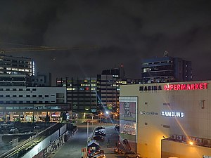
Marina Mall Accra
Shopping mall in Accra, Ghana
Distance: Approx. 1204 meters
Latitude and longitude: 5.603016,-0.17611739
Marina Mall Accra is a shopping center located at Airport City Accra in the Greater Accra Region of Ghana
Airport Residential Area
Town in Greater Accra Region, Ghana
Distance: Approx. 577 meters
Latitude and longitude: 5.6,-0.18333333
Airport Residential Area is a town in the Accra Metropolitan district, a district of the Greater Accra Region of Ghana.
Pig Farm (Ghana)
Town in Greater Accra Region, Ghana
Distance: Approx. 1503 meters
Latitude and longitude: 5.6,-0.2
Pig Farm is a town in the Accra Metropolitan district. Pig Farm has now surpassed Maamobi and Nima in crime rates. Pig Farm has recorded the highest school dropouts in the Ayawaso constituency.
Accra Girls Senior High School
Senior High School
Distance: Approx. 1177 meters
Latitude and longitude: 5.5969887,-0.195156
Accra Girls Senior High School is an all female second cycle institution in Accra in the Greater Accra Region, Ghana. It operates as a non-denominational day and boarding school. It runs courses in business, general science, general arts, home economics and visual arts, leading to the award of a West African Senior High School Certificate (WASSCE).

Bats at 37 Military Hospital
Colony of bats in Ghana
Distance: Approx. 1735 meters
Latitude and longitude: 5.588577,-0.183246
The Bats at the 37 military hospital are a colony of an estimated 1 million straw-coloured fruit bats living in the 37 Military Hospital area of Accra, the capital of Ghana. A local legend surrounds this group of animals, saying that a long time ago, a chief from a village in eastern Ghana Kibi was admitted to the hospital accompanied by megabats. He died but the bats never left the area and are still waiting for him to leave the hospital.

Consolidated Bank Ghana
Commercial bank in Ghana
Distance: Approx. 1167 meters
Latitude and longitude: 5.59972222,-0.17722222
Consolidated Bank Ghana (CBG) is a commercial bank in Ghana. It is licensed by the Bank of Ghana, the central bank and national banking regulator.

Ayawaso West Municipal District
Municipal District in Ghana
Distance: Approx. 1965 meters
Latitude and longitude: 5.61472222,-0.20083333
Ayawaso West Municipal District is one of the twenty-nine districts in Greater Accra Region, Ghana. Originally it was formerly part of the then-larger Accra Metropolitan District in 1988, until a small portion of the district was split off to create Ayawaso West Municipal District on 15 March 2018; thus the remaining part has been retained as Accra Metropolitan District. The municipality is located in the central part of Greater Accra Region and has Dzorwulu as its capital town.

Ghana National Mosque
Mosque in Accra, Ghana
Distance: Approx. 1479 meters
Latitude and longitude: 5.59069444,-0.18958333
The Ghana National Mosque is a mosque in Ghana. It is the second largest mosque in West Africa. The mosque was built at a cost of $10 million.
Weather in this IP's area
few clouds
26 Celsius
26 Celsius
26 Celsius
26 Celsius
1013 hPa
89 %
1013 hPa
1007 hPa
10000 meters
3.6 m/s
260 degree
20 %
05:46:36
17:47:22