196.195.15.224 - IP Lookup: Free IP Address Lookup, Postal Code Lookup, IP Location Lookup, IP ASN, Public IP
Country:
Region:
City:
Location:
Time Zone:
Postal Code:
ISP:
ASN:
language:
User-Agent:
Proxy IP:
Blacklist:
IP information under different IP Channel
ip-api
Country
Region
City
ASN
Time Zone
ISP
Blacklist
Proxy
Latitude
Longitude
Postal
Route
db-ip
Country
Region
City
ASN
Time Zone
ISP
Blacklist
Proxy
Latitude
Longitude
Postal
Route
IPinfo
Country
Region
City
ASN
Time Zone
ISP
Blacklist
Proxy
Latitude
Longitude
Postal
Route
IP2Location
196.195.15.224Country
Region
laghman
City
mehtar lam
Time Zone
Asia/Kabul
ISP
Language
User-Agent
Latitude
Longitude
Postal
ipdata
Country
Region
City
ASN
Time Zone
ISP
Blacklist
Proxy
Latitude
Longitude
Postal
Route
Popular places and events near this IP address

Laghman Province
Province of Afghanistan
Distance: Approx. 1533 meters
Latitude and longitude: 34.66,70.2
Laghman (Pashto: لغمان) is one of the 34 provinces of Afghanistan, located in the eastern part of the country. It has a population of about 502,148, which is multi-ethnic and mostly a rural society. Laghman hosts a large number of historical landmarks, minarets, monuments, and other cultural relics that are manifestation of its old history and culture.

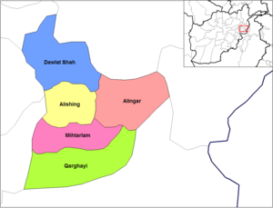
Mihtarlam District
District of Laghman Province
Distance: Approx. 3850 meters
Latitude and longitude: 34.6456,70.1814
Mihtarlam District is located in the center of Laghman Province of Afghanistan and consists of the urban centre and provincial capital Mihtarlam, 24 major villages and 269 sub-villages.

Mihtarlam
City in Laghman Province, Afghanistan
Distance: Approx. 345 meters
Latitude and longitude: 34.66833333,70.20888889
Mihtarlam (Pashto: مهترلام), also spelled Mehtar Lam, is the sixteenth most populous city of Afghanistan. It is the capital of Laghman Province and center of Mihtarlam District. It is the only large urban settlement in the province.
Alishang
Village, river, and valley in Afghanistan
Distance: Approx. 6264 meters
Latitude and longitude: 34.70333333,70.15305556
Alishang is the name of a village, a river and a fertile valley of Laghman Province, and also of the district headquarters of Mihtarlam District, in eastern Afghanistan. It lies about 40 km northwest of Jalalabad. The fertile Alishang valley drained by the Alishang River, which is described as "contracted", has an abundance of mounds and caves.

Aramaic inscription of Laghman
Rock inscription by Ashoka
Distance: Approx. 9952 meters
Latitude and longitude: 34.5846,70.1834
The Aramaic inscription of Laghman, also called the Laghman I inscription to differentiate from the Laghman II inscription discovered later, is an inscription on a slab of natural rock in the area of Laghmân, Afghanistan, written in Aramaic by the Indian emperor Ashoka about 260 BCE, and often categorized as one of the Minor Rock Edicts of Ashoka. This inscription was published in 1970 by André Dupont-Sommer. Since Aramaic was an official language of the Achaemenid Empire, and reverted to being just its vernacular tongue in 320 BCE with the conquests of Alexander the Great, it seems that this inscription was addressed directly to the populations of this ancient empire still present in this area, or to border populations for whom Aramaic remained the language used in everyday life.

Pul-i-Darunteh Aramaic inscription
Distance: Approx. 9952 meters
Latitude and longitude: 34.5846,70.1834
The Pul-i-Darunteh Aramaic inscription, also called Aramaic inscription of Lampaka, is an inscription on a rock in the valley of Laghman ("Lampaka" being the transcription in Sanskrit of "Laghman"), Afghanistan, written in Aramaic by the Indian emperor Ashoka around 260 BCE. It was discovered in 1932 at a place called Pul-i-Darunteh. Since Aramaic was the official language of the Achaemenid Empire, which disappeared in 320 BCE with the conquests of Alexander the Great, it seems that this inscription was addressed directly to the populations of this ancient empire still present in northwestern India, or to border populations for whom Aramaic remained the language of use.

Laghman massacre
War crime perpetrated by the Soviet Army
Distance: Approx. 1533 meters
Latitude and longitude: 34.66,70.2
The Laghman massacre was a war crime perpetrated by the Soviet Army in April 1985 in the villages of Kas-Aziz-Khan, Charbagh, Bala Bagh, Sabzabad, Mamdrawer, Haider Khan and Pul-i-Joghi in the Laghman Province, during the Soviet–Afghan War. Between 500 and 1,000 civilians were murdered in what was described as Soviet reprisals against civilians for anti-communist resistance members and their military actions aimed against the Soviet Army. The Soviet troops arrived with 200 tanks and armored personnel carriers on 11 March 1985 in the said villages in search for the Mujahideen, rejecting an offer from the Democratic Republic of Afghanistan to send their own troops to reduce the number of fatalities.
Qala-e-Seraj
Palace in Afghanistan
Distance: Approx. 711 meters
Latitude and longitude: 34.6651618,70.211085
Qala-e-Seraj is a palace located in Mihtarlam, Laghman Province, Afghanistan. It was built by Amir Habibullah Khan c. 1912–13 to spend his winters there.
Hajji Dunya Gul Niazi Jamia Masjid
Mosque in Mihtarlam, Laghman, Afghanistan
Distance: Approx. 1779 meters
Latitude and longitude: 34.6872518,70.2069226
Hajji Dunya Gul Niazi Jamia Masjid (Pashto: حاجی دنیا ګل نیازی جامعه مسجد) is a mosque in the city of Mihtarlam in Laghman Province, Afghanistan. Construction work on two mosques was launched in 2017. The second mosque opened in 2021 and has a capacity of 2,000 worshippers at a time.
Weather in this IP's area
overcast clouds
10 Celsius
8 Celsius
10 Celsius
10 Celsius
1019 hPa
31 %
1019 hPa
896 hPa
10000 meters
1.73 m/s
1.84 m/s
309 degree
100 %