196.10.248.211 - IP Lookup: Free IP Address Lookup, Postal Code Lookup, IP Location Lookup, IP ASN, Public IP
Country:
Region:
City:
Location:
Time Zone:
Postal Code:
IP information under different IP Channel
ip-api
Country
Region
City
ASN
Time Zone
ISP
Blacklist
Proxy
Latitude
Longitude
Postal
Route
Luminati
Country
ASN
Time Zone
Africa/Johannesburg
ISP
IS
Latitude
Longitude
Postal
IPinfo
Country
Region
City
ASN
Time Zone
ISP
Blacklist
Proxy
Latitude
Longitude
Postal
Route
IP2Location
196.10.248.211Country
Region
gauteng
City
germiston
Time Zone
Africa/Johannesburg
ISP
Language
User-Agent
Latitude
Longitude
Postal
db-ip
Country
Region
City
ASN
Time Zone
ISP
Blacklist
Proxy
Latitude
Longitude
Postal
Route
ipdata
Country
Region
City
ASN
Time Zone
ISP
Blacklist
Proxy
Latitude
Longitude
Postal
Route
Popular places and events near this IP address

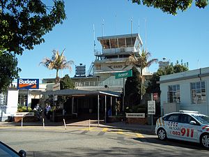
Germiston
Place in Gauteng, South Africa
Distance: Approx. 3 meters
Latitude and longitude: -26.21777778,28.16722222
Germiston, also known as kwaDukathole, is a city in the East Rand region of Gauteng, South Africa, administratively forming part of the City of Ekurhuleni Metropolitan Municipality since the latter's establishment in 2000. It functions as the municipal seat of Ekurhuleni, hosting the municipal council and administration. Originally a mining town established in 1886 at the start of the Witwatersrand Gold Rush, Germiston has since developed into one of the largest manufacturing, trucking and railway hubs in Africa, and is a major centre of the South African steel industry.
The Gables, Gauteng
Place in Gauteng, South Africa
Distance: Approx. 5086 meters
Latitude and longitude: -26.206,28.118
The Gables is a suburb of Johannesburg, South Africa. It is located in Region F of the City of Johannesburg Metropolitan Municipality.
Rand Airport
General aviation airport of Johannesburg; in Germiston, Gauteng, South Africa
Distance: Approx. 3185 meters
Latitude and longitude: -26.2425,28.15111111
Rand Airport (IATA: QRA, ICAO: FAGM) is an airport in Germiston, South Africa. It was constructed in the 1920s as the main airport for Johannesburg, but the city outgrew it and replaced the airport with Palmietfontein Airport in 1948 (itself replaced by Jan Smuts International Airport in 1952).
Reiger Park
Place in Gauteng, South Africa
Distance: Approx. 5090 meters
Latitude and longitude: -26.231,28.216
Reiger Park is a township situated in Boksburg in the Ekurhuleni Metropolitan Municipality, Gauteng, South Africa. It was established as Stirtonville after the Second World War when people influxed from rural areas seeking work on the gold mines. In 1963, due to the apartheid government's policy of separate development, the Black people were moved to Vosloorus, the Indians to Actonville and the coloured people were left to stay in Stirtonville, then renamed Reiger Park.

Germiston Stadium
Sports venue in Germiston, South Africa
Distance: Approx. 1357 meters
Latitude and longitude: -26.22787778,28.17485
Germiston Stadium (formerly the Herman Immelman Stadium) is a multi-purpose stadium in Germiston, South Africa. It is currently used mostly for rugby matches and track events. Germiston Stadium is the home stadium of Germiston Simmer Rugby Club and Germiston Football Club.
Rand Refinery
Precious metals refinery in South Africa
Distance: Approx. 1224 meters
Latitude and longitude: -26.21888889,28.155
Rand Refinery (Pty) Limited is the world's largest integrated single-site precious metals refining and smelting complex. It was established in 1920 to refine gold within South Africa, which had previously been refined in London.
St Catherine's School, Germiston
Private, co-educational day school in Germiston, Gauteng, South Africa
Distance: Approx. 2728 meters
Latitude and longitude: -26.23888889,28.18111111
St Catherine's School is an independent, co-educational school in Germiston, Gauteng named after Saint Catherine of Siena. A combined school, St Catherine's consists of a pre-school, a preparatory school and a senior school and is the oldest school in Germiston.
St Boniface Church, Germiston
Church in Gauteng, South Africa
Distance: Approx. 947 meters
Latitude and longitude: -26.211355,28.16101
St Boniface Church is the mother church of the Anglican parish of Germiston, Gauteng which also includes the chapelries of St Mary and St John in Lambton, and St Mark in Rosedeep. The parish is part of the Diocese of the Highveld, which is in turn part of the Anglican Church of Southern Africa (previously known as The Church of the Province of Southern Africa).
Elsburg
Place in Gauteng, South Africa
Distance: Approx. 4245 meters
Latitude and longitude: -26.245,28.197
Elsburg is a town in Ekurhuleni in the Gauteng province of South Africa. It is a town some 6 km south-east of Germiston.
Primrose, South Africa
Place in Gauteng, South Africa
Distance: Approx. 3837 meters
Latitude and longitude: -26.18333333,28.16666667
Primrose is a suburb of Germiston in Ekurhuleni, Gauteng, South Africa. It is an old residential area built in the early 1900s, in response to the gold rush.
Germiston High School
School
Distance: Approx. 2326 meters
Latitude and longitude: -26.236955,28.157903
Germiston High School (established September 1917) is a South African English-medium government school based in Germiston, Gauteng. It is the second oldest high school in Germiston.

Comair Flight 206
1988 aviation accident
Distance: Approx. 1616 meters
Latitude and longitude: -26.21666667,28.18333333
On Tuesday 1 March 1988, Comair Flight 206, an Embraer EMB-110P1 Bandeirante flying from Phalaborwa to Johannesburg was approaching Johannesburg International Airport to land when it broke up in flight over Germiston. Reports indicated an explosive device on board; the cockpit was found a quarter of a kilometer away from the rest of the fuselage, despite the flight having been relatively low at the time of the accident. A miner on board had taken out a large life insurance policy shortly before the flight.
Weather in this IP's area
broken clouds
17 Celsius
17 Celsius
16 Celsius
18 Celsius
1020 hPa
94 %
1020 hPa
842 hPa
10000 meters
1.54 m/s
40 degree
82 %


