Country:
 Great Britain
Region:
City:
Latitude and Longitude:
Time Zone:
Postal Code:
IP information under different IP Channel
ip-api
Country
Region
City
ASN
Time Zone
ISP
Blacklist
Proxy
Latitude
Longitude
Postal
Route
IPinfo
Country
Region
City
ASN
Time Zone
ISP
Blacklist
Proxy
Latitude
Longitude
Postal
Route
MaxMind
Country
Region
City
ASN
Time Zone
ISP
Blacklist
Proxy
Latitude
Longitude
Postal
Route
Luminati
Country
GBRegion
eng
City
leeds
ASN
Time Zone
Europe/London
ISP
Pulsant (Scotland) Ltd
Latitude
Longitude
Postal
db-ip
Country
Region
City
ASN
Time Zone
ISP
Blacklist
Proxy
Latitude
Longitude
Postal
Route
ipdata
Country
Region
City
ASN
Time Zone
ISP
Blacklist
Proxy
Latitude
Longitude
Postal
Route
Popular places and events near this IP address

Harehills
Area of Leeds, West Yorkshire, England
Distance: Approx. 883 meters
Latitude and longitude: 53.8066,-1.5053
Harehills is an inner-city area of east Leeds, West Yorkshire, England. It is about 1 mile (1.6 km) northeast of Leeds city centre. Harehills is between the A58 (towards Wetherby) and the A64 (towards York).
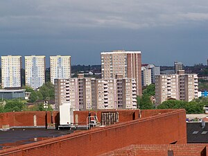
Burmantofts
Human settlement in England
Distance: Approx. 608 meters
Latitude and longitude: 53.8048,-1.5166
Burmantofts is an area of 1960s high-rise housing blocks in inner-city east Leeds, West Yorkshire, England adjacent to the city centre and St. James's Hospital. It is a racially diverse area, with sizable Afro-Caribbean and Irish communities, but suffers the social problems typical of similar areas across the country.
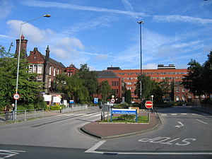
St James's University Hospital
Hospital in West Yorkshire, England
Distance: Approx. 993 meters
Latitude and longitude: 53.80805556,-1.51861111
St James's University Hospital is a tertiary hospital in Leeds, West Yorkshire, England and is popularly known as Jimmy's. It is the 8th largest hospital by beds in the United Kingdom, popularised for its television coverage from 1987 to 1996. It is managed by the Leeds Teaching Hospitals NHS Trust.

Thackray Museum of Medicine
Medical museum in West Yorkshire, England
Distance: Approx. 986 meters
Latitude and longitude: 53.80805556,-1.51833333
The Thackray Museum of Medicine in Leeds, West Yorkshire, England, is a museum of the history of medicine adjacent to St James's University Hospital. It opened in March 1997 as the Thackray Medical Museum. In 1998 it won "Museum of the Year" and has other awards including in 2004 both the "Excellence in England Small Tourist Attraction of the Year" and "Sandford Award for Heritage Education".

Co-op Academy Leeds
Co-operative academy in Leeds, West Yorkshire, England
Distance: Approx. 647 meters
Latitude and longitude: 53.80288,-1.52095
Co-op Academy Leeds (formerly Primrose High School) is a co-operative academy in Leeds, West Yorkshire, England. It is a part of the Co-op Academies Trust, which is sponsored by The Co-operative Group.

Neville Hill TMD
Train Maintenance Depot in West Yorkshire, England
Distance: Approx. 976 meters
Latitude and longitude: 53.7923,-1.5051
Neville Hill is a railway train maintenance depot in Osmondthorpe, Leeds, England on the Leeds to Selby Line. The depot is situated 2 miles 14 chains (3.5 km) to the east of Leeds railway station on the north side of the line.

Osmondthorpe
District of east Leeds, West Yorkshire, England
Distance: Approx. 907 meters
Latitude and longitude: 53.79587,-1.50051
Osmondthorpe a district of east Leeds in West Yorkshire, England is considered part of the Halton Moor district. It is situated in the LS9 Leeds postcode area, two miles (3 km) to the east of Leeds city centre between East End Park and Halton Moor. The district is part of the Burmantofts and Richmond Hill Ward of the Leeds Metropolitan Council.

Lincoln Green
Area in Leeds, West Yorkshire, England
Distance: Approx. 711 meters
Latitude and longitude: 53.805,-1.519
Lincoln Green is a mainly residential area of Leeds, West Yorkshire, England around Lincoln Green Road, and is adjacent to and southwest of St James's University Hospital. It falls within the Burmantofts and Richmond Hill ward of the City of Leeds Council. The area was given this name in 1954, at the start of major redevelopment by the City Council.

St Patrick's Church, Leeds
Church in Leeds, England
Distance: Approx. 1056 meters
Latitude and longitude: 53.7991,-1.5285
St Patrick's Church is the name of two Roman Catholic Parish Churches in Leeds, West Yorkshire, England. The first church was built from 1889 to 1891, designed by John Kelly, and is a Grade II listed building. It is on Rider Street, next to the New York Road and East Street Arts.
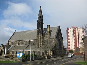
St Agnes' Church, Burmantofts
Church in Leeds, England
Distance: Approx. 648 meters
Latitude and longitude: 53.80494444,-1.51741667
St. Agnes' Church in Burmantofts, Leeds, West Yorkshire, England is an active Anglican parish church in the archdeaconry of Leeds and the Diocese of Leeds.
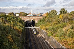
Richmond Hill Tunnel
Railway tunnel in Leeds, England
Distance: Approx. 829 meters
Latitude and longitude: 53.795,-1.522
Richmond Hill Tunnel is a railway tunnel to the east of Leeds city centre, in West Yorkshire, England. The tunnel is known to be the first in the world specifically designed to carry passengers to be worked by steam trains rather than a stationary engine. One of the innovative methods employed to reassure passengers going through the lightless tunnel, was to place copper sheets underneath the air shafts which were intended to reflect the light around the tunnel.

Beckett Street Cemetery
Burial ground in Leeds, Yorkshire, England
Distance: Approx. 823 meters
Latitude and longitude: 53.807,-1.516
Beckett Street Cemetery (also known as Burmantofts Cemetery) is a closed cemetery in Burmantofts, Leeds, West Yorkshire, England. Founded in 1842, the site was officially opened in 1845 and is recognised as being one of England's first municipal burial sites (Hunslet Cemetery, also in Leeds, opened one month earlier). Although the cemetery was closed to interments in 2001, it remains open for visitors, and has two listed structures besides being a listed park itself.
Weather in this IP's area
clear sky
11 Celsius
11 Celsius
10 Celsius
12 Celsius
994 hPa
93 %
994 hPa
986 hPa
10000 meters
2.06 m/s
60 degree
07:20:56
18:25:46