195.97.18.151 - IP Lookup: Free IP Address Lookup, Postal Code Lookup, IP Location Lookup, IP ASN, Public IP
Country:
 Greece
Region:
City:
Location:
Time Zone:
Postal Code:
ISP:
ASN:
language:
User-Agent:
Proxy IP:
Blacklist:
IP information under different IP Channel
ip-api
Country
Region
City
ASN
Time Zone
ISP
Blacklist
Proxy
Latitude
Longitude
Postal
Route
db-ip
Country
Region
City
ASN
Time Zone
ISP
Blacklist
Proxy
Latitude
Longitude
Postal
Route
IPinfo
Country
Region
City
ASN
Time Zone
ISP
Blacklist
Proxy
Latitude
Longitude
Postal
Route
IP2Location
195.97.18.151Country
grRegion
kriti
City
irakleion
Time Zone
Europe/Athens
ISP
Language
User-Agent
Latitude
Longitude
Postal
ipdata
Country
Region
City
ASN
Time Zone
ISP
Blacklist
Proxy
Latitude
Longitude
Postal
Route
Popular places and events near this IP address
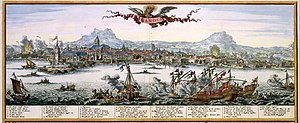
Siege of Candia
1648–69 battle of the Cretan War
Distance: Approx. 1102 meters
Latitude and longitude: 35.33333333,25.13333333
The siege of Candia (now Heraklion, Crete) was a military conflict in which Ottoman forces besieged the Venetian-ruled capital city of the Kingdom of Candia. Lasting from 1648 to 1669, or a total of 21 years, one of the longest sieges in history. It ended with an Ottoman victory, but the effort and cost of the siege contributed to the decline of the Ottoman Empire, especially after the Great Turkish War.

Heraklion Archaeological Museum
Archaeological museum in Crete, Greece
Distance: Approx. 1353 meters
Latitude and longitude: 35.3387436,25.1369119
The Heraklion Archaeological Museum is a museum located in Heraklion on Crete. It is one of the largest museums in Greece and the best in the world for Minoan art, as it contains by far the most important and complete collection of artefacts of the Minoan civilization of Crete. It is normally referred to scholarship in English as "AMH" (for "Archaeological Museum of Heraklion"), a form still sometimes used by the museum in itself.

Museum of the Battle of Crete and the National Resistance
Museum in Heraklion, Crete
Distance: Approx. 1371 meters
Latitude and longitude: 35.33938889,25.13827778
The Museum of the Battle of Crete and the National Resistance (Greek: Μουσείο Μάχης Κρήτης και Εθνικής Αντίστασης) is a municipal historical museum dedicated to the defense of Crete during WWII and the popular resistance of Crete. It is located near the Heraklion Archaeological Museum in the city of Heraklion on the island of Crete, Greece. It was founded by the Municipality of Heraklion in May 1994.

Lions Square
Square in Heraklion, Crete, Greece
Distance: Approx. 1568 meters
Latitude and longitude: 35.3391,25.1331
Eleftheriou Venizelou Square (Greek: Πλατεία Ελευθερίου Βενιζέλου) is a square in the city of Heraklion in Crete, named after the Cretan statesman Eleftherios Venizelos. It dates back to the Venetian era and is more commonly known as Lions Square (Greek: Πλατεία Λεόντων) or Leonton Square (genitive), after the Venetian-era Morosini Fountain (popularly called "τα Λιοντάρια", "The Lions") in its midst, which features four lions supporting the main basin.
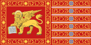
Kingdom of Candia
Crete under Venetian rule
Distance: Approx. 1540 meters
Latitude and longitude: 35.31666667,25.13333333
The Realm or Kingdom of Candia (Venetian: Regno de Càndia; Italian: Regno di Candia; Greek: Βασίλειο της Κάντιας, romanized: Vasíleio tis Kántias) or Duchy of Candia (Venetian: Dogado de Càndia; Italian: Ducato di Candia; Greek: Δουκάτο της Κάντιας, romanized: Doukáto tis Kántias) was the official name of Crete during the island's period as an overseas colony of the Republic of Venice, from the initial Venetian conquest in 1205–1212 to its fall to the Ottoman Empire during the Cretan War (1645–1669). The island was at the time and up to the early modern era commonly known as Candia after its capital, Candia or Chandax (modern Heraklion). In modern Greek historiography, the period is known as the Venetocracy (Greek: Βενετοκρατία, romanized: Venetokratía, or Ενετοκρατία, Enetokratía).
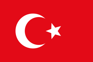
Ottoman Crete
Province of the Ottoman Empire from 1646 to 1898
Distance: Approx. 1102 meters
Latitude and longitude: 35.33333333,25.13333333
The island of Crete (Ottoman Turkish: كریت, romanized: Girit) was declared an Ottoman province (eyalet) in 1646, after the Ottomans managed to conquer the western part of the island as part of the Cretan War, but the Venetians maintained their hold on the capital Candia, until 1669, when Francesco Morosini surrendered the keys of the town. The offshore island fortresses of Souda, Grambousa, and Spinalonga would remain under Venetian rule until 1715, when they were also captured by the Ottomans. Crete took part in the Greek War of Independence, but the local uprising was suppressed with the aid of Muhammad Ali of Egypt.
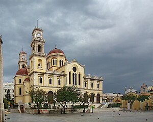
Agios Minas Cathedral
Greek cathedral in Heraklion, Crete, Greece
Distance: Approx. 1571 meters
Latitude and longitude: 35.3375,25.13083333
The Agios Minas Cathedral (Greek: ῾Ιερός Μητροπολιτικός Ναός ῾Αγίου Μηνᾶ) is a Greek Orthodox Cathedral in Heraklion, Greece, serving as the seat of the Archbishop of Crete. Ιt is dedicated to Saint Menas the martyr and wonderworker (285-309 A.D.), who is the patron saint of Heraklion.
Battle of Heraklion
World War II battle in Crete
Distance: Approx. 1050 meters
Latitude and longitude: 35.33638889,25.13861111
The Battle of Heraklion was part of the Battle of Crete, fought during World War II on the Greek island of Crete between 20 and 30 May 1941. British, Australian and Greek forces of 14th Infantry Brigade, commanded by Brigadier Brian Chappel, defended Heraklion port and airfield against a German paratrooper attack by the 1st Parachute Regiment of the 7th Air Division, commanded by Colonel Bruno Bräuer. The attack on Heraklion during the afternoon of 20 May was one of four airborne assaults on Crete that day, following German attacks against Maleme airfield and the main port of Chania in the west of Crete in the morning.

Siege of Chandax
Successful Byzantine siege of Muslim Crete
Distance: Approx. 1527 meters
Latitude and longitude: 35.33861111,25.13305556
The siege of Chandax in 960-961 was the centerpiece of the Byzantine Empire's campaign to recover the island of Crete which since the 820s had been ruled by Muslim Arabs. The campaign followed a series of failed attempts to reclaim the island from the Muslims stretching as far back as 827, only a few years after the initial conquest of the island by the Arabs, and was led by the general and future emperor Nikephoros Phokas. It lasted from autumn 960 until spring 961, when the main Muslim fortress and capital of the island, Chandax (modern Heraklion) was captured.
Nikos Kazantzakis Stadium
Football stadium in Heraklion, Crete, Greece
Distance: Approx. 1253 meters
Latitude and longitude: 35.3318,25.1305
The «Nikos Kazantzakis» Stadium (Greek: Γήπεδο «Νίκος Καζαντζάκης»), formerly known as Ergotelis Stadium and more commonly as Martinengo Stadium, is a football stadium located on the Martinengo bastion, part of the fortifications of Heraklion, on the island of Crete. It is named after Modern Greek literature giant Nikos Kazantzakis, whose grave is also located on the same bastion. It is part of the Ergotelis Athletic Centre, a sport facilities complex owned by Greek multi-sport club Ergotelis.

Candia massacre
1898 massacre of civilians in Crete
Distance: Approx. 1102 meters
Latitude and longitude: 35.33333333,25.13333333
The Candia massacre occurred on 6 September 1898, on Crete, then part of the Ottoman Empire. It occurred as a reaction by armed Muslim irregular groups (Bashi-bazouks) to the offer to the Christian community of a series of civil rights by foreign powers. They attacked the British security force in Candia (modern Heraklion), which was part of an international security force on the island.

Cultural and Conference Center of Heraklion
Distance: Approx. 1378 meters
Latitude and longitude: 35.33361111,25.13
Cultural and Conference Center of Heraklion (Greek: Πολιτιστικό και Συνεδριακό Κέντρο Ηρακλείου, ΠΣΚΗ), also Cultural and Conference Center of Crete (Πολιτιστικό και Συνεδριακό Κέντρο Κρήτης), is a centre for the performing arts in Heraklion, Greece. It was inaugurated in 2019 after long debates and planning that exceeded four decades. The complex is built on a plot of 5,670 square meters and has a total area of 28,487 square meters.
Weather in this IP's area
light rain
13 Celsius
12 Celsius
10 Celsius
13 Celsius
1022 hPa
82 %
1022 hPa
992 hPa
10000 meters
10.8 m/s
340 degree
75 %