195.95.146.248 - IP Lookup: Free IP Address Lookup, Postal Code Lookup, IP Location Lookup, IP ASN, Public IP
Country:
Region:
City:
Location:
Time Zone:
Postal Code:
ISP:
ASN:
language:
User-Agent:
Proxy IP:
Blacklist:
IP information under different IP Channel
ip-api
Country
Region
City
ASN
Time Zone
ISP
Blacklist
Proxy
Latitude
Longitude
Postal
Route
db-ip
Country
Region
City
ASN
Time Zone
ISP
Blacklist
Proxy
Latitude
Longitude
Postal
Route
IPinfo
Country
Region
City
ASN
Time Zone
ISP
Blacklist
Proxy
Latitude
Longitude
Postal
Route
IP2Location
195.95.146.248Country
Region
rheinland-pfalz
City
minden
Time Zone
Europe/Berlin
ISP
Language
User-Agent
Latitude
Longitude
Postal
ipdata
Country
Region
City
ASN
Time Zone
ISP
Blacklist
Proxy
Latitude
Longitude
Postal
Route
Popular places and events near this IP address

Irrel
Municipality in Rhineland-Palatinate, Germany
Distance: Approx. 1726 meters
Latitude and longitude: 49.84722222,6.45611111
Irrel is a municipality in the district Bitburg-Prüm, in Rhineland-Palatinate, Germany. It is situated in the Eifel, near the border with Luxembourg, at the confluence of the rivers Prüm and Nims. It is located approximately 15 km south-west of Bitburg and 5 km north-east of Echternach.

Steinheim, Luxembourg
Distance: Approx. 2203 meters
Latitude and longitude: 49.81666667,6.48333333
Steinheim (Luxembourgish: Steenem) is a town in the commune of Rosport-Mompach, in eastern Luxembourg. As of 2024, the town has a population of 654.

Abbey of Echternach
Benedictine monastery in Echternach, Luxembourg
Distance: Approx. 3840 meters
Latitude and longitude: 49.81388889,6.4225
The Abbey of Echternach is a Benedictine monastery in the town of Echternach, in eastern Luxembourg. The abbey was founded in the 7th century by St Willibrord, the patron saint of Luxembourg. For three hundred years, it benefited from the patronage of a succession of rulers, and was the most powerful institution in Luxembourg.

VictoriArena
Distance: Approx. 3935 meters
Latitude and longitude: 49.80846,6.505675
VictoriArena is a football stadium in Rosport, in eastern Luxembourg and is currently the home stadium of FC Victoria Rosport. The stadium has a capacity of 2,500.

Echternacherbrück
Municipality in Rhineland-Palatinate, Germany
Distance: Approx. 3544 meters
Latitude and longitude: 49.81305556,6.42861111
Echternacherbrück is a German municipality located on the Sauer river opposite the Luxembourgish town of Echternach. It is part of the district Bitburg-Prüm, in Rhineland-Palatinate. It includes the district of Fölkenbach.

Eisenach, Rhineland-Palatinate
Municipality in Rhineland-Palatinate, Germany
Distance: Approx. 3689 meters
Latitude and longitude: 49.85222222,6.50888889
Eisenach is a municipality in the district of Bitburg-Prüm, in Rhineland-Palatinate, western Germany.

Ernzen, Germany
Municipality in Rhineland-Palatinate, Germany
Distance: Approx. 3097 meters
Latitude and longitude: 49.84166667,6.42555556
Ernzen is a municipality in the district of Bitburg-Prüm, in Rhineland-Palatinate, western Germany.

Menningen
Municipality in Rhineland-Palatinate, Germany
Distance: Approx. 1194 meters
Latitude and longitude: 49.83333333,6.48333333
Menningen is a municipality in the district of Bitburg-Prüm, in Rhineland-Palatinate, western Germany.

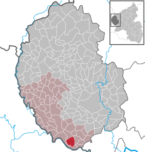
Minden, Rhineland-Palatinate
Municipality in Rhineland-Palatinate, Germany
Distance: Approx. 962 meters
Latitude and longitude: 49.82472222,6.46833333
Minden is a municipality in the district of Bitburg-Prüm, in Rhineland-Palatinate, western Germany.
Irrel (Verbandsgemeinde)
Distance: Approx. 1708 meters
Latitude and longitude: 49.847,6.456
Irrel was a former Verbandsgemeinde ("collective municipality") in the district Bitburg-Prüm, in Rhineland-Palatinate, Germany. The seat of the Verbandsgemeinde was in Irrel. On 1 July 2014 it merged into the new Verbandsgemeinde Südeifel.

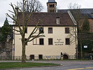
Prehistory Museum, Echternach
Museum in Echternach, Luxembourg
Distance: Approx. 3875 meters
Latitude and longitude: 49.8128,6.4231
The Prehistory Museum (Luxembourgish: Musée fir Virgeschicht; French: Musée de la préhistoire) in Echternach, Luxembourg, houses a collection of prehistoric artefacts principally from Luxembourg, northern Europe and France testifying to the history of mankind for more than a million years. It is located in the 15th century Hihof building in the centre of the town.
Devil's Gorge (Eifel)
Distance: Approx. 2304 meters
Latitude and longitude: 49.84555556,6.44083333
The Devil's Gorge or Teufelsschlucht is located on the eastern edge of the Ferschweiler Plateau within the South Eifel Nature Park in the vicinity of Irrel. It was formed towards the end of the last ice age, about 10,000 years ago as the result of one or more rock collapses. The cause of this event was probably a combination of the geological and climatic circumstances.
Weather in this IP's area
light rain
3 Celsius
-1 Celsius
3 Celsius
4 Celsius
1004 hPa
96 %
1004 hPa
968 hPa
69 meters
5.42 m/s
12.67 m/s
300 degree
100 %