Country:
 France
Region:
City:
Latitude and Longitude:
Time Zone:
Postal Code:
IP information under different IP Channel
ip-api
Country
Region
City
ASN
Time Zone
ISP
Blacklist
Proxy
Latitude
Longitude
Postal
Route
IPinfo
Country
Region
City
ASN
Time Zone
ISP
Blacklist
Proxy
Latitude
Longitude
Postal
Route
MaxMind
Country
Region
City
ASN
Time Zone
ISP
Blacklist
Proxy
Latitude
Longitude
Postal
Route
Luminati
Country
FRASN
Time Zone
Europe/Paris
ISP
Free Pro SAS
Latitude
Longitude
Postal
db-ip
Country
Region
City
ASN
Time Zone
ISP
Blacklist
Proxy
Latitude
Longitude
Postal
Route
ipdata
Country
Region
City
ASN
Time Zone
ISP
Blacklist
Proxy
Latitude
Longitude
Postal
Route
Popular places and events near this IP address

Montigny-le-Bretonneux
Commune in Île-de-France, France
Distance: Approx. 1414 meters
Latitude and longitude: 48.7711,2.0333
Montigny-le-Bretonneux (French pronunciation: [mɔ̃tiɲi lə bʁətɔnø] ) is a commune in the Yvelines department in the Île-de-France region in north-central France. It is located in the south-western suburbs of Paris, 24.5 kilometres (15.2 miles) from the centre of Paris, in the "new town" of Saint-Quentin-en-Yvelines, of which it is the central and most populated commune.
Trappes
Commune in Île-de-France, France
Distance: Approx. 970 meters
Latitude and longitude: 48.7775,2.0025
Trappes (French: [tʁap] ) is a commune in the Yvelines department, Île-de-France region, Northern France. It is a banlieue located in the western outer suburbs of Paris, 26.7 km (16.6 mi) from the centre of Paris, part of the new town of Saint-Quentin-en-Yvelines.

Étang de Saint-Quentin
Reservoir in Yvelines
Distance: Approx. 1381 meters
Latitude and longitude: 48.7878,2.0097
The Étang de Saint-Quentin, or pond of Trappes, is the largest body of fresh water in Yvelines with a surface of approximately 2.5 km². It on in the perimeter of the new town of Saint-Quentin-in-Yvelines, in the commune of Trappes and Montigny-le-Bretonneux. The lake an important base of outdoor recreation.

Fort de Saint-Cyr
Distance: Approx. 2201 meters
Latitude and longitude: 48.79284,2.03124
The Fort de Saint-Cyr, located in the commune of Montigny-le-Bretonneux, (Yvelines), is one of the forts built at the end of the 19th century to defend Paris. After the first world war the fort was used as an army weather station and arms depot. Classed in 1992 as a monument historique, it is now used as a film depository for the preservation of movies under the Cinémathèque française.

Fort de Bois-d'Arcy
Distance: Approx. 2253 meters
Latitude and longitude: 48.793238,2.031623
The Fort de Bois-d'Arcy, also called the Batterie de Bois-d'Arcy, is one of the forts constructed at the end of the 19th century to defend Paris. It is located in the commune of Bois d'Arcy in the Yvelines département of France. The fort is located in the southern part of the town to the south of Route nationale 12.

Institut Culturel Franco-Japonais – École Japonaise de Paris
Primary & middle school in Montigny-le-Bretonneux, France
Distance: Approx. 2204 meters
Latitude and longitude: 48.7913,2.0346
The Institut Culturel Franco-Japonais – École Japonaise de Paris ("French-Japanese Cultural Institute - Japanese School of Paris" - Japanese: 日仏文化学院パリ日本人学校 Nichifutsu Bunka Gakuin Pari Nihonjin Gakkō) is a Japanese international school located in Montigny-le-Bretonneux, France, in the Paris Metropolitan Area. The school is located in proximity to Versailles. Japanese is the primary language of instruction while students also take French classes.

Vélodrome National
French arena for track cycling
Distance: Approx. 1924 meters
Latitude and longitude: 48.78777778,2.03472222
The Vélodrome National de Saint-Quentin-en-Yvelines is a velodrome in Montigny-le-Bretonneux, France. It was built between 2011 and 2014 and hosted the 2015, 2022 UCI Track Cycling World Championships, and the 2016 UEC European Track Championships. It hosted the cycling venue in the 2024 Summer Olympics.
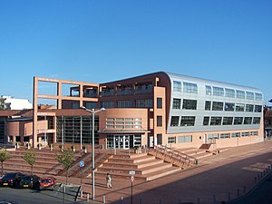
Lycée Descartes de Montigny le Bretonneux
School in Montigny-le-Bretonneux, France
Distance: Approx. 2082 meters
Latitude and longitude: 48.7653,2.0388
Lycée Descartes de Montigny le Bretonneux is a senior high school located in the Sourderie area, in Montigny-le-Bretonneux, Yvelines, France, in the Paris metropolitan area. It opened in 1980 with 60 students, and at the time it was integrated with the Collège Hélène Boucher junior high school. As of autumn 2014 it had 940 students, and in 2023 it has a little more than 1000 students.
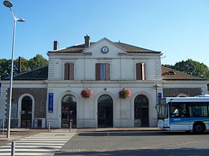
Trappes station
Distance: Approx. 659 meters
Latitude and longitude: 48.775,2.00666667
Trappes is a station on the Paris–Brest railway. It is served by suburban Transilien Line N and U services. The station opened on 12 July 1849 (1849-07-12).
Canton of Montigny-le-Bretonneux
Distance: Approx. 1916 meters
Latitude and longitude: 48.77,2.04
The canton of Montigny-le-Bretonneux is an administrative division of the Yvelines department, northern France. Its borders were not modified at the French canton reorganisation which came into effect in March 2015. Its seat is in Montigny-le-Bretonneux.
Canton of Trappes
Distance: Approx. 1924 meters
Latitude and longitude: 48.78,1.99
The canton of Trappes is an administrative division of the Yvelines department, northern France. Its borders were modified at the French canton reorganisation which came into effect in March 2015. Its seat is in Trappes.
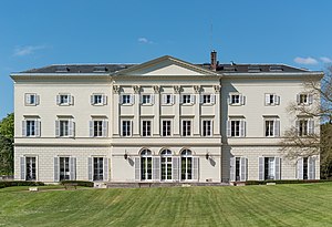
Château de Jouy-en-Josas
Distance: Approx. 1455 meters
Latitude and longitude: 48.76299667,2.01746694
The Château de Jouy-en-Josas is in Jouy-en-Josas, southwest of Paris, in the French department of Yvelines, in the Île-de-France region. It is a partly preserved castle, currently occupied by HEC Paris for its continuing education activities (Executive education) and as a seminar site.
Weather in this IP's area
scattered clouds
13 Celsius
12 Celsius
12 Celsius
13 Celsius
1010 hPa
93 %
1010 hPa
990 hPa
10000 meters
4.12 m/s
220 degree
40 %
07:19:13
20:20:11