Country:
 Netherlands
Region:
City:
Latitude and Longitude:
Time Zone:
Postal Code:
IP information under different IP Channel
ip-api
Country
Region
City
ASN
Time Zone
ISP
Blacklist
Proxy
Latitude
Longitude
Postal
Route
IPinfo
Country
Region
City
ASN
Time Zone
ISP
Blacklist
Proxy
Latitude
Longitude
Postal
Route
MaxMind
Country
Region
City
ASN
Time Zone
ISP
Blacklist
Proxy
Latitude
Longitude
Postal
Route
Luminati
Country
NLASN
Time Zone
Europe/Amsterdam
ISP
BIT BV
Latitude
Longitude
Postal
db-ip
Country
Region
City
ASN
Time Zone
ISP
Blacklist
Proxy
Latitude
Longitude
Postal
Route
ipdata
Country
Region
City
ASN
Time Zone
ISP
Blacklist
Proxy
Latitude
Longitude
Postal
Route
Popular places and events near this IP address

Sloterdijk, Amsterdam
Former village in North Holland, Netherlands
Distance: Approx. 1971 meters
Latitude and longitude: 52.38333333,4.85
Sloterdijk was a village in the Dutch province of North Holland. It now is a part of the municipality of Amsterdam, and lies about 3 km northwest of the city centre. Since 2010 Sloterdijk has formed part of the stadsdeel of Amsterdam-West.
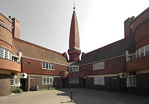
Het Schip
Museum in Amsterdam, the Netherlands
Distance: Approx. 2368 meters
Latitude and longitude: 52.3903,4.8735
Het Schip (English: The Ship) is a building complex in the Spaarndammerbuurt neighbourhood of Amsterdam, the Netherlands. The complex in the architectural style of the Amsterdam School was designed by Michel de Klerk in 1919. It originally contained 102 homes (now 82) for the working class, a small meeting hall, a post office, and an elementary school.

Millennium Tower (Amsterdam)
Distance: Approx. 886 meters
Latitude and longitude: 52.393333,4.837222
Millennium Tower is a 97.5 metres (320 ft), 24 storey office building in Amsterdam constructed from 2002 and completed in 2004.

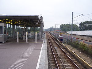
Amsterdam Sloterdijk station
Railway station in Amsterdam, Netherlands
Distance: Approx. 1304 meters
Latitude and longitude: 52.38916667,4.83805556
Amsterdam Sloterdijk is a major railway junction to the west of Amsterdam Centraal station. It is at a rail-rail crossing, with an additional chord (Hemboog). It is on the railway line from Amsterdam Centraal to Haarlem and the last station before the junction where the line Amsterdam Centraal-Zaandam diverges from it and on the crossing west branch of the Amsterdam–Schiphol railway line between Schiphol and Amsterdam Centraal.
De Vlugtlaan metro station
Metro station in Amsterdam, the Netherlands
Distance: Approx. 2367 meters
Latitude and longitude: 52.37944444,4.83805556
De Vlugtlaan is a metro station on Line 50 and Line 51 in Amsterdam, the Netherlands. Between 1986 and 2000, Amsterdam De Vlugtlaan railway station was in use on the railway running parallel next to the metro line.

Westpoort
Area of Amsterdam in North Holland, Netherlands
Distance: Approx. 1595 meters
Latitude and longitude: 52.40583333,4.82111111
Westpoort (Western Gateway or Western Port) is an international port area and one of the largest industrial parks in the Netherlands. The area covers the Port of Amsterdam and the industrial area in the northwest of Amsterdam.

Coentunnel
Tunnel in Amsterdam, Netherlands
Distance: Approx. 2084 meters
Latitude and longitude: 52.41416667,4.86388889
The Coentunnel (1966) is a tunnel in the A10 motorway under the North Sea Canal in western Amsterdam. The tunnel is named for the 17th-century colonizer Jan Pieterszoon Coen. The tunnel itself is 1283 metres long of which 587 metres are fully covered.

Second Coen Tunnel
Distance: Approx. 2087 meters
Latitude and longitude: 52.4142,4.86389
The Second Coen Tunnel is a tunnel under the North Sea Canal, next to the Coen Tunnel in Amsterdam. The tunnel was built in combination with a new highway connection, the Westrandweg, to the A5 motorway. The tunnel consists of 3 fixed lanes and two reversible lanes, which are opened in the direction where traffic is the heaviest.

Bos en Lommer
Neighborhood of Amsterdam in North Holland, Netherlands
Distance: Approx. 1971 meters
Latitude and longitude: 52.38333333,4.85
Bos en Lommer (Dutch pronunciation: [ˈbɔs ɛn ˈlɔmər]; English: Wood and Shade) is a neighborhood of Amsterdam, Netherlands. From 1990 to 2010 it was considered a district of the municipality of Amsterdam in the province of North Holland. As of May 1, 2010, it was merged into the new Amsterdam-West borough.
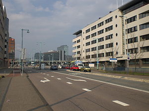
Teleport (Amsterdam)
Neighborhood of Amsterdam in North Holland, Netherlands
Distance: Approx. 1537 meters
Latitude and longitude: 52.38694444,4.83861111
Teleport is a neighborhood of Amsterdam, Netherlands in the urban district of Westpoort. Teleport was founded in the 1980s as an office location with the designation of "Telematics." Therefore, it has specific facilities in that area. The neighborhood has connections by road through the A10 motorway, railway lines, buses and underground (the Amsterdam Sloterdijk railway station).
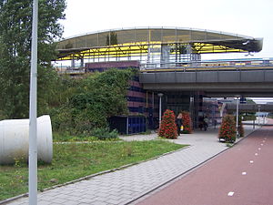
Isolatorweg metro station
Metro station in Amsterdam
Distance: Approx. 780 meters
Latitude and longitude: 52.39527778,4.85055556
Isolatorweg metro station is the terminus of the Amsterdam metro 50 (Ringlijn) and opened on 28 May 1997. From 3 March 2019 this is also the terminus of the Amsterdam metro 51. The station is a railway embankment near the Isolatorweg on an industrial estate close to an electric generating station in the western harbour area of Amsterdam.

Hembrug
Distance: Approx. 2374 meters
Latitude and longitude: 52.41972222,4.82777778
The name Hembrug refers to various geographic entities in the municipality of Zaanstad, in the Netherlands.
Weather in this IP's area
few clouds
21 Celsius
21 Celsius
20 Celsius
22 Celsius
1008 hPa
70 %
1008 hPa
1008 hPa
10000 meters
6.17 m/s
190 degree
20 %
07:03:57
20:12:50