195.74.73.62 - IP Lookup: Free IP Address Lookup, Postal Code Lookup, IP Location Lookup, IP ASN, Public IP
Country:
 Germany
Region:
City:
Location:
Time Zone:
Postal Code:
ISP:
ASN:
language:
User-Agent:
Proxy IP:
Blacklist:
IP information under different IP Channel
ip-api
Country
Region
City
ASN
Time Zone
ISP
Blacklist
Proxy
Latitude
Longitude
Postal
Route
db-ip
Country
Region
City
ASN
Time Zone
ISP
Blacklist
Proxy
Latitude
Longitude
Postal
Route
IPinfo
Country
Region
City
ASN
Time Zone
ISP
Blacklist
Proxy
Latitude
Longitude
Postal
Route
IP2Location
195.74.73.62Country
deRegion
baden-wurttemberg
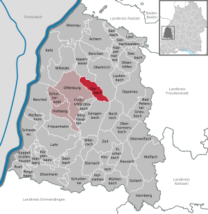
City
offenburg
Time Zone
Europe/Berlin
ISP
Language
User-Agent
Latitude
Longitude
Postal
ipdata
Country
Region
City
ASN
Time Zone
ISP
Blacklist
Proxy
Latitude
Longitude
Postal
Route
Popular places and events near this IP address

Offenburg
City in Baden-Württemberg, Germany
Distance: Approx. 1188 meters
Latitude and longitude: 48.46666667,7.93333333
Offenburg ("open borough" - coat of arms showing open gates; Low Alemmanic: Offäburg) is a city in the state of Baden-Württemberg, in south-western Germany. With nearly 60,000 inhabitants (2019), it is the largest city and the administrative capital of the Ortenaukreis.

Ortenau
Historic region in Baden-Württemberg, Germany
Distance: Approx. 4259 meters
Latitude and longitude: 48.473,8.003
The Ortenau, originally called Mortenau, is a historic region in the present-day German state of Baden-Württemberg. It is located on the right bank of the river Rhine, stretching from the Upper Rhine Plain to the foothill zone of the Black Forest. In the south, it borders on the Breisgau region, covering approximately the same area as the Ortenaukreis, a present-day administrative district with its centre at Offenburg.
Durbach
Municipality in Baden-Württemberg, Germany
Distance: Approx. 6019 meters
Latitude and longitude: 48.5,8.01666667
Durbach is a municipality in the district of Ortenau in Baden-Württemberg in Germany. It is situated on the verge of the northern Black Forest Mountains six kilometers north east of the town of Offenburg. Main branches of commerce are agriculture (especially production of wine) and tourism.
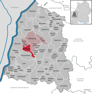
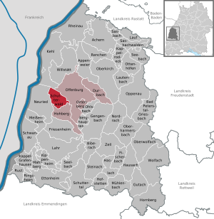
Hohberg
Municipality in Baden-Württemberg, Germany
Distance: Approx. 6190 meters
Latitude and longitude: 48.42388889,7.90833333
Hohberg (Low Alemannic: Hohberig) is a municipality in the district of Ortenau in Baden-Württemberg in Germany.

Ohlsbach
Municipality in Baden-Württemberg, Germany
Distance: Approx. 5949 meters
Latitude and longitude: 48.43277778,7.99694444
Ohlsbach (Low Alemannic: Ohlschbach) is a town in the district of Ortenau in Baden-Württemberg in Germany.
Schutterwald
Municipality in Baden-Württemberg, Germany
Distance: Approx. 4906 meters
Latitude and longitude: 48.45833333,7.88305556
Schutterwald is a town in the district of Ortenau in Baden-Württemberg in Germany.

Ortenberg, Baden-Württemberg
Municipality in Baden-Württemberg, Germany
Distance: Approx. 3152 meters
Latitude and longitude: 48.45138889,7.97138889
Ortenberg (German: [ˈɔʁtn̩bɛʁk] ; Low Alemannic: Ordäberig) is a municipality in the district of Ortenaukreis, Baden-Württemberg.

The Graduate School of Offenburg University of Applied Sciences
Distance: Approx. 1669 meters
Latitude and longitude: 48.4589,7.94278
The Graduate School of the University of Applied Sciences Offenburg is a public university located in the town of Offenburg, Baden-Württemberg, Germany. The Graduate School offers four international Master's degree programs with focus ranging from Communication and Media to Energy Conversion and Business Consulting. The Master's program of Communication and Media Engineering is ranked in Top 10 2008 Germany International Master Degree Courses from DAAD. More recently the MBA (IBC) program has been ranked within the QS 200 Business Schools Report.

Offenburg station
Railway station in Offenburg, Germany
Distance: Approx. 260 meters
Latitude and longitude: 48.47611111,7.94583333
Offenburg station (German: Bahnhof Offenburg) is a railway station in Baden-Württemberg and has seven tracks on four platforms. Offenburg used to be a railway town and the station was of major economic importance to it. In recent years the maintenance facilities and much of the rail freight yards have been closed.

Brandeckkopf
Distance: Approx. 6546 meters
Latitude and longitude: 48.46666667,8.03333333
The Brandeckkopf is 686.1 m above sea level (NHN), and the highest mountain in the borough of Offenburg. At 686.1 metres above sea level, the Brandeckkopf is the highest mountain of Offenburg. It is located within the Zell-Weierbach district.
University of Applied Sciences Offenburg
University in Germany
Distance: Approx. 1670 meters
Latitude and longitude: 48.45888889,7.94277778
The University of Applied Sciences Offenburg, with its head office in Offenburg and a branch in Gengenbach, is a German university owned by the state of Baden-Württemberg. It is one of the most important educational institutions in the southern Upper Rhine area. Currently, about 4,090 students are enrolled.

Ortenberg Castle
Distance: Approx. 3933 meters
Latitude and longitude: 48.4437,7.9732
Ortenberg Castle is the main landmark of the Ortenau and is situated above the town of Ortenberg at the end of the Kinzig Valley between Offenburg and Gengenbach. The origins of the Ortenau Castle can be traced back to the 11th/12th century. The castle was built by the House of Zähringen to protect the Kinzig Valley.
Weather in this IP's area
moderate rain
5 Celsius
4 Celsius
5 Celsius
6 Celsius
1021 hPa
95 %
1021 hPa
995 hPa
3100 meters
2.06 m/s
30 degree
75 %