Country:
 Norway
Region:
City:
Latitude and Longitude:
Time Zone:
Postal Code:
IP information under different IP Channel
ip-api
Country
Region
City
ASN
Time Zone
ISP
Blacklist
Proxy
Latitude
Longitude
Postal
Route
IPinfo
Country
Region
City
ASN
Time Zone
ISP
Blacklist
Proxy
Latitude
Longitude
Postal
Route
MaxMind
Country
Region
City
ASN
Time Zone
ISP
Blacklist
Proxy
Latitude
Longitude
Postal
Route
Luminati
Country
NORegion
02
City
rykkin
ASN
Time Zone
Europe/Oslo
ISP
Telenor Norge AS
Latitude
Longitude
Postal
db-ip
Country
Region
City
ASN
Time Zone
ISP
Blacklist
Proxy
Latitude
Longitude
Postal
Route
ipdata
Country
Region
City
ASN
Time Zone
ISP
Blacklist
Proxy
Latitude
Longitude
Postal
Route
Popular places and events near this IP address

Oslo Airport, Gardermoen
International airport serving Oslo, Norway
Distance: Approx. 1269 meters
Latitude and longitude: 60.20277778,11.08388889
Oslo Airport (Norwegian: Oslo lufthavn) (IATA: OSL, ICAO: ENGM), alternatively referred to as Oslo Gardermoen Airport or simply Gardermoen, is an international airport serving Oslo, the capital and most populous city of Norway. A hub for Scandinavian Airlines and an operating base for Norwegian Air Shuttle and Widerøe, in 2011, it connected to 26 domestic and 158 international destinations. The airport is located 19 nautical miles (35 km; 22 mi) northeast of Oslo, at Gardermoen at the border of municipalities Nannestad and Ullensaker, in Akershus county.
Sessvollmoen
Village in Østlandet, Norway
Distance: Approx. 5191 meters
Latitude and longitude: 60.235,11.1469
Sessvollmoen is a village in the municipality of Ullensaker, Norway. Its population (2023) is 1302.

Maura, Norway
Village in Østlandet, Norway
Distance: Approx. 5203 meters
Latitude and longitude: 60.25,11.01666667
Maura is a village in the municipality of Nannestad, Norway. It is located a few miles north of Oslo Airport. Its population (2020) is 4,224.

Teigebyen
Village in Østlandet, Norway
Distance: Approx. 2734 meters
Latitude and longitude: 60.2228,11.0242
Teigebyen is the administrative centre in Nannestad municipality, Norway. It is located southwest of Råholt, and northwest of Gardermoen. As of 2021, its population was 3,144.

Oslo Airport location controversy
Long-running debate in Norway
Distance: Approx. 2341 meters
Latitude and longitude: 60.1974,11.1001
The location of the main airport serving the city of Oslo, Norway, has been the subject of several political debates since 1918. The first controversy was initially related to choice between the islands of Gressholmen and Lindøya in the Oslofjord for a water aerodrome. The debate later changed, arriving at the decision in 1933, to locate a new airport at Fornebu.
Norwegian Armed Forces Aircraft Collection
Military aviation museum in Norway
Distance: Approx. 2381 meters
Latitude and longitude: 60.18915278,11.06955278
Norwegian Armed Forces Aircraft Collection (Forsvarets flysamling Gardermoen) is a military aviation museum located at Gardermoen, north of Oslo in Akershus county, Norway. The founding of the Norwegian Aviation Historical Society in 1967, gave the first boost to the idea of preserving aircraft in Norway. The Collection's Heinkel He 111 and Northrop N-3PB are among the aircraft traced, recovered and restored at the instigation of the NAHS. From the latter part of the 1970s onwards, a considerable number of historical aircraft were assembled in an old ex-Luftwaffe hangar at Gardermoen and from the mid-1980s the public were admitted to the hangar during summer.
Gardermoen, Norway
Distance: Approx. 1950 meters
Latitude and longitude: 60.21666667,11.1
Gardermoen is an area at the border of the municipalities Nannestad and Ullensaker in Akershus, Norway. In 1998, it had a population of 259 people. Oslo Airport, Gardermoen, Gardermoen Air Station, Norwegian Armed Forces Aircraft Collection and Oslo Airport Station (train station) are located in the area.
Brudalen
Farm in Østlandet, Norway
Distance: Approx. 5210 meters
Latitude and longitude: 60.16666667,11.1
Brudalen is a farm in Ullensaker, Akershus, Norway.
Kringler
Village in Østlandet, Norway
Distance: Approx. 5278 meters
Latitude and longitude: 60.23333333,10.98333333
Kringler is a village in Nannestad, Akershus, Norway.
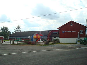
Mogreina
Village in Østlandet, Norway
Distance: Approx. 5849 meters
Latitude and longitude: 60.23027778,11.165
Mogreina is a village in Ullensaker, Akershus, Norway. It is located 10 kilometres (6.2 mi) away from Gardermoen.It has one school with around 150 students.

Trandum leir
Former army camp in Østlandet, Norway
Distance: Approx. 3315 meters
Latitude and longitude: 60.21027778,11.12694444
Trandum leir is a former army camp Ullensaker, Norway. The camp was shut down when the civilian airport at Gardermoen was built since most of the buildings were located directly underneath the flightpath for planes landing there. The woods near Trandum were an infamous site of execution of political prisoners during the Occupation of Norway by Nazi Germany.

Hemus Air Flight 7081
1996 aircraft hijacking
Distance: Approx. 1768 meters
Latitude and longitude: 60.219,11.094
Hemus Air Flight 7081 was the hijacking of a Tupolev Tu-154 operated by Hemus Air on 3 September 1996. The incident occurred on-route from Beirut International Airport in Lebanon to Varna Airport in Bulgaria. The hijacker, Palestinian Hazem Salah Abdallah, a defector of the Popular Front for the Liberation of Palestine (PFLP), falsely claimed he had explosives on board.
Weather in this IP's area
fog
12 Celsius
12 Celsius
12 Celsius
13 Celsius
1017 hPa
93 %
1017 hPa
994 hPa
7000 meters
2.06 m/s
40 degree
67 %
06:27:39
19:59:22