Country:
Region:
City:
Latitude and Longitude:
Time Zone:
Postal Code:
IP information under different IP Channel
ip-api
Country
Region
City
ASN
Time Zone
ISP
Blacklist
Proxy
Latitude
Longitude
Postal
Route
Luminati
Country
ASN
Time Zone
Europe/Bratislava
ISP
SWAN, a.s.
Latitude
Longitude
Postal
IPinfo
Country
Region
City
ASN
Time Zone
ISP
Blacklist
Proxy
Latitude
Longitude
Postal
Route
db-ip
Country
Region
City
ASN
Time Zone
ISP
Blacklist
Proxy
Latitude
Longitude
Postal
Route
ipdata
Country
Region
City
ASN
Time Zone
ISP
Blacklist
Proxy
Latitude
Longitude
Postal
Route
Popular places and events near this IP address

Bratislava Region
Region of Slovakia
Distance: Approx. 229 meters
Latitude and longitude: 48.14388889,17.10972222
The Bratislava Region (Slovak: Bratislavský kraj, pronounced [ˈbracislawskiː ˈkraj]; German: Pressburger/Bratislavaer Landschaftsverband (until 1919); Hungarian: Pozsonyi kerület) is one of the administrative regions of Slovakia. Its capital is Bratislava. The region was first established in 1923 and its present borders exist from 1996.

Gamča
Public school
Distance: Approx. 286 meters
Latitude and longitude: 48.144,17.116
Gamča (Slovak pronunciation: [ˈɡamtʂa]), today officially Gymnázium, Grösslingová 18, Bratislava, is a public coeducational gymnasium located in Bratislava, Slovakia. It educates around 600 pupils in 8-year long and 4-year long programs leading to Maturita. It was founded in 1626 by Peter Cardinal Pazmáň (Péter Pázmany) as Collegium Posoniense.

Academy of Performing Arts in Bratislava
Performing arts college in Slovakia
Distance: Approx. 229 meters
Latitude and longitude: 48.14388889,17.10972222
The Academy of Performing Arts in Bratislava (Slovak: Vysoká škola múzických umení v Bratislave, abbr. VŠMU) is a university founded on June 9, 1949.

Primate's Palace, Bratislava
Palace in Bratislava, Slovakia
Distance: Approx. 234 meters
Latitude and longitude: 48.14416667,17.10944444
The Primate's Palace (Slovak: Primaciálny palác) is a neoclassical palace in the Old Town of Bratislava the capital of Slovakia. It was built from 1778 to 1781 for Archbishop József Batthyány, after the design of architect Melchior Hefele. In 1805, the Palace's Hall of Mirrors saw the signing of the fourth Peace of Pressburg, ending the War of the Third Coalition.

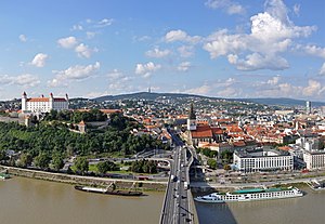
Bratislava
Capital and largest city of Slovakia
Distance: Approx. 229 meters
Latitude and longitude: 48.14388889,17.10972222
Bratislava, historically known as Pozsony and Pressburg, is the capital and largest city of the Slovak Republic and the fourth largest of all cities on the River Danube. Officially, the population of the city is about 475,000; however, some sources estimate it to be more than 660,000—approximately 140% of the official figures. Bratislava is in southwestern Slovakia at the foot of the Little Carpathians, occupying both banks of the River Danube and the left bank of the River Morava.
Laurinc Gate
City gate from medieval fortifications in Bratislava, Slovakia
Distance: Approx. 183 meters
Latitude and longitude: 48.1436,17.1109
Laurinc Gate (Slovak: Laurinská brána) was a medieval town gate in the historical Old Town of Bratislava, the capital of Slovakia. It was built in the 14th century and demolished by the order of Empress Maria Theresa of Austria in the 18th century together with most of the city walls, because the inner walls were limiting the town's growth. It was named after Saint Lawrence.

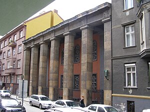
Heydukova Street Synagogue
Orthodox synagogue in Bratislava, Slovakia
Distance: Approx. 223 meters
Latitude and longitude: 48.1469,17.1123
The Heydukova Street Synagogue (Slovak: Synagóga na Heydukovej ulici) is an Orthodox congregation, synagogue, and Jewish museum, located on Heydukova Street in the Old Town of Bratislava, the capital of Slovakia. It is the only synagogue in Bratislava.
Timeline of Bratislava
Distance: Approx. 229 meters
Latitude and longitude: 48.143889,17.109722
The following is a timeline of the history of the city of Bratislava, Slovakia.

SNP Square (Bratislava)
Square in central Bratislava, Slovakia
Distance: Approx. 135 meters
Latitude and longitude: 48.145466,17.110795
Slovak National Uprising Square (SNP square; Slovak: Námestie Slovenského národného povstania, shortcut: Námestie SNP or Nám. SNP) is a square in central Bratislava, Slovakia. In the 20th century, it served as the focal point for national demonstrations for independence and sovereignty.

Námestie Nežnej revolúcie
Distance: Approx. 46 meters
Latitude and longitude: 48.1448,17.1118
Námestie Nežnej revolúcie (transl. Velvet Revolution square) is a square in the Old Town borough of Bratislava adjacent to the SNP Square in front of the Old Market Hall. The square was given the name on 15 November 2019 to commemorate the 30 anniversary of the Velvet Revolution. The new name was introduced by the Mayor of Bratislava during a ceremony on 16 November 2019.

Astorka Korzo '90 Theatre
Theatre in Bratislava, Slovakia
Distance: Approx. 98 meters
Latitude and longitude: 48.14416667,17.11166667
Astorka Korzo '90 Theatre (Slovak: Divadlo Astorka Korzo '90) is a theatre in the Slovak capital of Bratislava, founded on 1 April 1991.

Manderlák Building
High-rise building in Bratislava
Distance: Approx. 36 meters
Latitude and longitude: 48.14458,17.11246
The Manderlák (Slovak: Obchodný a obytný dom Manderla) is a high-rise residential building in Bratislava, Slovakia. Standing at 45 metres (147 ft) tall with 11 floors and built between 1934 and 1935, the construction was the first-ever high-rise building in Slovakia and the tallest in the country between 1935 and 1967.
Weather in this IP's area
broken clouds
6 Celsius
6 Celsius
5 Celsius
7 Celsius
1027 hPa
89 %
1027 hPa
1009 hPa
10000 meters
1.03 m/s
75 %
06:58:49
16:13:48
