Country:
Region:
City:
Latitude and Longitude:
Time Zone:
Postal Code:
IP information under different IP Channel
ip-api
Country
Region
City
ASN
Time Zone
ISP
Blacklist
Proxy
Latitude
Longitude
Postal
Route
Luminati
Country
Region
ki
City
spisskanovaves
ASN
Time Zone
Europe/Bratislava
ISP
SWAN, a.s.
Latitude
Longitude
Postal
IPinfo
Country
Region
City
ASN
Time Zone
ISP
Blacklist
Proxy
Latitude
Longitude
Postal
Route
db-ip
Country
Region
City
ASN
Time Zone
ISP
Blacklist
Proxy
Latitude
Longitude
Postal
Route
ipdata
Country
Region
City
ASN
Time Zone
ISP
Blacklist
Proxy
Latitude
Longitude
Postal
Route
Popular places and events near this IP address

Spišská Nová Ves
Town in Slovakia
Distance: Approx. 521 meters
Latitude and longitude: 48.94388889,20.5675
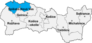
Spišská Nová Ves (; Hungarian: Igló; German: (Zipser) Neu(en)dorf) is a town in the Košice Region of Slovakia. The town is located southeast of the High Tatras in the Spiš region, and lies on both banks of the Hornád River. It is the biggest town of the Spišská Nová Ves District.

Spišská Nová Ves District
District in Košice Region, Slovakia
Distance: Approx. 427 meters
Latitude and longitude: 48.945,20.56416667
Spišská Nová Ves District (Slovak: okres Spišská Nová Ves) is a district in the Košice Region of eastern Slovakia. The district in its present borders was established in 1996. Administrative, economic and cultural center is its seat Spišská Nová Ves.
Danišovce
Village and municipality in Slovakia
Distance: Approx. 5354 meters
Latitude and longitude: 48.95,20.63333333
Danišovce (Hungarian: Dénesfalva) is a village and municipality in the Spišská Nová Ves District in the Košice Region of central-eastern Slovakia.

Harichovce
Village and municipality in Slovakia
Distance: Approx. 3216 meters
Latitude and longitude: 48.96666667,20.58333333
Harichovce (Hungarian: Pálmafalva) is a village and municipality in the Spišská Nová Ves District in the Košice Region of central-eastern Slovakia.

Iliašovce
Village and municipality in Slovakia
Distance: Approx. 5062 meters
Latitude and longitude: 48.98333333,20.53333333
Iliašovce (Hungarian: Illésfalva) is a village and municipality in the Spišská Nová Ves District in the Košice Region of central-eastern Slovakia.

Lieskovany
Village and municipality in Slovakia
Distance: Approx. 4161 meters
Latitude and longitude: 48.93333333,20.61666667
Lieskovany (Hungarian: Leszkovány) is a tiny village and municipality in the Spišská Nová Ves District in the Košice Region of central-eastern Slovakia.

Markušovce
Village in Slovakia
Distance: Approx. 5966 meters
Latitude and longitude: 48.91666667,20.63333333
Markušovce (Slovak pronunciation: [ˈmarkuʂɔwtse]; Hungarian: Márkusfalva) is a village and municipality in the Spišská Nová Ves District in the Košice Region of central-eastern Slovakia.

Odorín
Village and municipality the Košice Region of central-eastern Slovakia
Distance: Approx. 5356 meters
Latitude and longitude: 48.93333333,20.63333333
Odorín (Hungarian: Szepesedelény) is a village and municipality in the Spišská Nová Ves District in the Košice Region of central-eastern Slovakia.

Teplička, Spišská Nová Ves District
Distance: Approx. 4026 meters
Latitude and longitude: 48.916831,20.601168
Teplička (Hungarian: Hernádtapolca) is a village and municipality in the Spišská Nová Ves District in the Košice Region of central-eastern Slovakia.
Smižany
Village in Slovakia
Distance: Approx. 2804 meters
Latitude and longitude: 48.95555556,20.52916667
Smižany (Hungarian: Szepessümeg, German: Schmögen) is a large village and municipality in the Spišská Nová Ves District in the Košice Region of central-eastern Slovakia. With a population of over 8,500 people as of 2021, Smižany is the largest village in Slovakia (a village being defined as a municipality that does not have town status). Smižany is situated directly adjacent to the town of Spišská Nová Ves and the two municipalities form a contiguous urban area, one of the main population centers in Eastern Slovakia.
Spiš Aréna
Distance: Approx. 198 meters
Latitude and longitude: 48.94305556,20.55944444
Spiš Arena is a sports arena in Spišská Nová Ves, Slovakia. It is primarily used for ice hockey, and is the home arena of HK Spišská Nová Ves. Spiš Arena was opened in 1982 as Zimný Štadión SNV and has a seating capacity for 5,503 people for Ice hockey games.
Spišská Nová Ves railway station
Railway station in Spišská Nová Ves, Slovakia
Distance: Approx. 955 meters
Latitude and longitude: 48.95027778,20.56111111
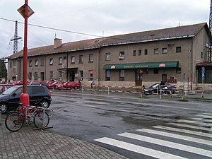
Spišská Nová Ves railway station (Slovak: Železničná stanica Spišská Nová Ves) serves the town and municipality of Spišská Nová Ves, in the Košice Region, eastern Slovakia. Opened in 1871, the station is a junction between the Košice–Žilina railway, which is part of Slovakia's main east–west rail corridor, and a 12 km (7.5 mi) spur line to Levoča. The station is currently owned by Železnice Slovenskej republiky (ŽSR); train services are operated by Železničná spoločnosť Slovensko (ZSSK).
Weather in this IP's area
few clouds
-0 Celsius
-0 Celsius
-1 Celsius
-0 Celsius
1027 hPa
83 %
1027 hPa
971 hPa
10000 meters
1.08 m/s
1.05 m/s
253 degree
24 %
06:47:32
15:57:29


