Country:
 Sweden
Region:
City:
Latitude and Longitude:
Time Zone:
Postal Code:
IP information under different IP Channel
ip-api
Country
Region
City
ASN
Time Zone
ISP
Blacklist
Proxy
Latitude
Longitude
Postal
Route
IPinfo
Country
Region
City
ASN
Time Zone
ISP
Blacklist
Proxy
Latitude
Longitude
Postal
Route
MaxMind
Country
Region
City
ASN
Time Zone
ISP
Blacklist
Proxy
Latitude
Longitude
Postal
Route
Luminati
Country
SERegion
m
City
landskrona
ASN
Time Zone
Europe/Stockholm
ISP
Telenor Norge AS
Latitude
Longitude
Postal
db-ip
Country
Region
City
ASN
Time Zone
ISP
Blacklist
Proxy
Latitude
Longitude
Postal
Route
ipdata
Country
Region
City
ASN
Time Zone
ISP
Blacklist
Proxy
Latitude
Longitude
Postal
Route
Popular places and events near this IP address
Landskrona Municipality
Municipality in Scania County, Sweden
Distance: Approx. 802 meters
Latitude and longitude: 55.86666667,12.83333333
Landskrona Municipality (Landskrona kommun) is a municipality in Scania County in Sweden. Its seat is located in the city of Landskrona. The island of Ven was added to the City of Landskrona in 1959.
Landskrona
Place in Scania, Sweden
Distance: Approx. 371 meters
Latitude and longitude: 55.87055556,12.83111111
Landskrona is a town in Scania, Sweden. Located on the shores of the Öresund, it occupies a natural port, which has lent the town at first military and subsequent commercial significance. Ferries operate from Landskrona to the island of Ven, and for many years there was also a connection to Copenhagen.

Landskrona IP
Football stadium in Sweden
Distance: Approx. 2011 meters
Latitude and longitude: 55.889934,12.83761
Landskrona IP (short for "Landskrona Idrottsplats" or "Landskrona Sports Ground" and locally known as "I.P.") is a football stadium which serves as the home of the Landskrona BoIS football club. The stadium holds approximately 10,000 spectators, 3,500 of whom are accommodated in covered seats on the south terrace. On the same site there are smaller football pitches and facilities for other sports including tennis.

Borstahusen
Distance: Approx. 3453 meters
Latitude and longitude: 55.9,12.8
Borstahusen is a former fishing village in northern Landskrona in Scania, in southern Sweden. It was founded in 1776 by the brothers Rasmus Andersson Borste and Jöns Andersson Borste, after whom the area is named. Around the original village, a recreational area has sprung up with camping, golf courses and beaches.
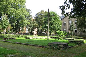
Saint John the Baptist's Church, Landskrona
Church ruin in Landskrona, Sweden
Distance: Approx. 310 meters
Latitude and longitude: 55.8722,12.8317
As a building Johannes Babtistæ Kirke ( John the Baptist's Church) is a former church in Landskrona, Scania, Sweden. Today it only offers outdoor services, but between around 1430 and 1753 it was the second largest church in Scania. The Church was demolished on orders of the Swedish military commendant in the town.

Sofia Albertina Church
Church in Landskrona Sweden, Sweden
Distance: Approx. 527 meters
Latitude and longitude: 55.86816667,12.82672222
Sofia Albertina Church (Swedish: Sofia Albertina kyrka) is the main church in Landskrona, Sweden. Belonging to the Landskrona Parish of the Church of Sweden, it was inaugurated in 1788 and fully completed in 1816. It is considered a rare church building, in the respect that it has two towers without being a Bishop's church.

Öresundsvarvet
Distance: Approx. 1363 meters
Latitude and longitude: 55.86083333,12.83055556
Öresundsvarvet was a Swedish shipyard in Landskrona that was established in 1915 and largely phased out between 1980 and 1982.
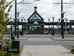
Landskrona Station
Railway station in Landskrona, Sweden
Distance: Approx. 1995 meters
Latitude and longitude: 55.87908333,12.85688889
Landskrona Station is the railway station in Landskrona. It first opened in January 2001 and is a part of the West Coast Line.
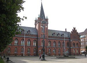
Landskrona Town Hall
Town hall in Sweden
Distance: Approx. 369 meters
Latitude and longitude: 55.87005556,12.82994444
Landskrona Town Hall (Swedish: Landskrona rådhus) is a town hall located in Landskrona. The town hall was inaugurated in the year 1884 after construction had started in 1882. The historical building has been designed by the Danish architect Ove Pedersen and is primarily used for Landskrona municipal council meetings.

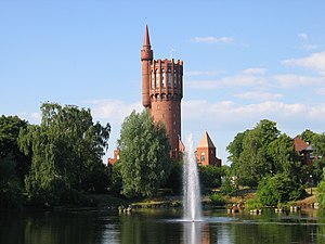
Landskrona Water Tower
A water tower in Landskrona, Sweden
Distance: Approx. 664 meters
Latitude and longitude: 55.86880556,12.81916667
Landskrona Water Tower (also called the New Water Tower by local name, in order distinguish it from the old water tower in the city) is a water tower located in Landskrona, Sweden. The tower has a circumference of 49 m (161 ft), is 65.9 m (216 ft) high and was completed in 1970. It replaced the old water tower which was put out of use in 1975.

Landskrona City Hall
Seat of Landskrona city government
Distance: Approx. 416 meters
Latitude and longitude: 55.86922222,12.82569444
Landskrona City Hall is a city hall in Landskrona that hosts the central government of Landskrona Municipality. The house is located by the new harbor, near the Sofia Albertina Church and barely half a kilometer east of the Landskrona Water Tower, which is located along the city's west coast. The building, designed by Sten Samuelson and Inge Stoltz, was inaugurated in September 1976 and most recently underwent an interior renovation that was completed in 2021.

John the Baptist Catholic Church
Catholic church and congregation in Landskrona, Sweden
Distance: Approx. 280 meters
Latitude and longitude: 55.87360278,12.83120556
John the Baptist Catholic Church (Swedish: Johannes Döparens katolska kyrka) is a catholic church and congregation located in Landskrona, Sweden. The church was originally a methodist church from its inauguration in 1905, however in 1995 the Roman Catholic church in Sweden acquired the church after the methodist congregation had ceased its activity. The building was renovated in order to prepare for its reinauguration as a catholic church.
Weather in this IP's area
scattered clouds
28 Celsius
28 Celsius
27 Celsius
28 Celsius
1011 hPa
50 %
1011 hPa
1010 hPa
10000 meters
5.93 m/s
8.61 m/s
147 degree
32 %
06:27:31
19:45:25