Country:
 Sweden
Region:
City:
Latitude and Longitude:
Time Zone:
Postal Code:
IP information under different IP Channel
ip-api
Country
Region
City
ASN
Time Zone
ISP
Blacklist
Proxy
Latitude
Longitude
Postal
Route
IPinfo
Country
Region
City
ASN
Time Zone
ISP
Blacklist
Proxy
Latitude
Longitude
Postal
Route
MaxMind
Country
Region
City
ASN
Time Zone
ISP
Blacklist
Proxy
Latitude
Longitude
Postal
Route
Luminati
Country
SERegion
ab
City
bromma
ASN
Time Zone
Europe/Stockholm
ISP
Telenor Norge AS
Latitude
Longitude
Postal
db-ip
Country
Region
City
ASN
Time Zone
ISP
Blacklist
Proxy
Latitude
Longitude
Postal
Route
ipdata
Country
Region
City
ASN
Time Zone
ISP
Blacklist
Proxy
Latitude
Longitude
Postal
Route
Popular places and events near this IP address

Järfälla Municipality
Municipality in Stockholm County, Sweden
Distance: Approx. 840 meters
Latitude and longitude: 59.43333333,17.83333333
Järfälla Municipality (Swedish: Järfälla kommun) is a municipality in Stockholm County in east central Sweden, and is considered a suburb of Stockholm. Its seat is located in Jakobsberg, part of the Stockholm urban area. Järfälla has not been amalgamated with other municipalities in the two local government reforms carried out during the 20th century.
Jakobsberg
Place in Järfälla Municipality, Sweden
Distance: Approx. 1018 meters
Latitude and longitude: 59.41666667,17.83333333
Jakobsberg is a suburban area (pop. ca 32 643 in the year 2022) within Stockholm urban area, and the seat of Järfälla Municipality, Stockholm County in Sweden. Jakobsberg, Järfälla's commercial and administrative centre, grew up around the railway.

Akalla
Urban district in Stockholm, Sweden
Distance: Approx. 4710 meters
Latitude and longitude: 59.41416667,17.91416667
Akalla is a district (Swedish: stadsdel) in Rinkeby-Kista borough, Stockholm, Sweden. Akalla has a population of roughly 9,100 as of 2018, in which immigrants, mostly from Asia and Africa, make up 60.4% of the population. Akalla is located on the blue metro line.

Barkarby Airport
Airport in Akalla
Distance: Approx. 3305 meters
Latitude and longitude: 59.41583333,17.88916667
Barkarby Airport (IATA: N/A, ICAO: ESKB) was a disbanded Swedish Air Force base, near Akalla north of Stockholm used for general aviation. Barkarby Airport was one of Sweden’s oldest active airports until it was closed in 2010. A large shopping complex is still situated close to – and partly on – the airfield.

Barkarby
District in Stockholm County, Sweden
Distance: Approx. 3262 meters
Latitude and longitude: 59.40027778,17.8625
Barkarby, also known as Barkarbystaden is an area in Järfälla Municipality, Stockholm County, Sweden, and part of the contiguously built-up Stockholm urban area. It is currently undergoing a large urban development through the Barkarbystaden project, transforming a former military airbase and airport area into an urban district. Barkarby has a station on the Stockholm commuter rail network, and two metro stations, Barkarby and Barkarbystaden are set to open in 2027 as an extension of the Stockholm Metro Blue Line.

Svea Air Corps
Military unit
Distance: Approx. 2744 meters
Latitude and longitude: 59.4125,17.875
Svea Air Corps (Swedish: Svea flygkår), also F 8 Barkarby, or simply F 8, is a former Swedish Air Force air corps wing with the main base located in Barkarby just north of the capital Stockholm on the east coast.

Akalla metro station
Stockholm Metro station
Distance: Approx. 4717 meters
Latitude and longitude: 59.41444444,17.91444444
Akalla is a station in the Stockholm metro in the Akalla district of Stockholm. The station was opened on 5 June 1977 as the northern terminus of the extension of the Blue line from Hallonbergen. This is the final stop on Line 11 of the Blue Line.

Hjulsta metro station
Stockholm Metro station
Distance: Approx. 4487 meters
Latitude and longitude: 59.39611111,17.88777778
Hjulsta metro station is a station on the blue line of the Stockholm metro, located in Hjulsta, northern Stockholm. The station was opened on 31 August 1975 as the northern terminus of the first stretch of the Blue Line from T-Centralen. The trains were then running via Hallonbergen and Rinkeby.
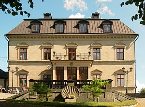
Görväln House
Building in Järfälla Municipality, Sweden
Distance: Approx. 2824 meters
Latitude and longitude: 59.43472222,17.7875
Görväln House (Swedish pronunciation: [ˈjœ̂rːvɛln]; Görvälns Slott) is a manor house at Järfälla Municipality in Stockholm County, Sweden. Görväln House is located at Görväln, a bay of lake Mälaren. The manor is now owned by Järfälla Municipality and since 2008 has been used as a hotel and restaurant.
Kallhäll
Distance: Approx. 3317 meters
Latitude and longitude: 59.45,17.8
Kallhäll is a neighbourhood in Järfälla Municipality, Stockholm County. It is a suburban part of Stockholm urban area with a population of 12,000 inhabitants as of 2011 (including Stäket). Kallhäll started as an industrial suburb when the industrialist Erik Bolinder decided to move his Bolinders Mechanical Shops to Kallhäll from Kungsholmen in central Stockholm.

Uppland Runic Inscription 92
Distance: Approx. 270 meters
Latitude and longitude: 59.42568889,17.82943889
Uppland Runic Inscription 92 is carved on a rune that now stands in the park at Jakobsberg folk highschool (Jakobsbergs folkhögskola) in Jakobsberg, in Järfälla Municipality just north of Stockholm. The rock is lightgrey granite.

Imam Ali Mosque (Järfälla)
Mosque in Järfälla, Stockholm, Sweden
Distance: Approx. 1452 meters
Latitude and longitude: 59.41361111,17.82508333
The Imam Ali Mosque (Swedish: Imam Ali moské), is a large Shia Muslim mosque in the country located in Järfälla Municipality, Stockholm County, Sweden. In May 2017, there was an arson attack against the building, a fire caused major damage to the facade and roof of a mosque. The attacker is believed to be an ISIS sympathiser or a far-right activist.
Weather in this IP's area
broken clouds
5 Celsius
5 Celsius
5 Celsius
8 Celsius
1009 hPa
100 %
1009 hPa
1006 hPa
10000 meters
75 %
07:10:30
18:01:28