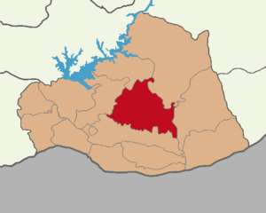
Country:
 Turkey
Region:
City:
Latitude and Longitude:
Time Zone:
Postal Code:
IP information under different IP Channel
ip-api
Country
Region
City
ASN
Time Zone
ISP
Blacklist
Proxy
Latitude
Longitude
Postal
Route
IPinfo
Country
Region
City
ASN
Time Zone
ISP
Blacklist
Proxy
Latitude
Longitude
Postal
Route
MaxMind
Country
Region
City
ASN
Time Zone
ISP
Blacklist
Proxy
Latitude
Longitude
Postal
Route
Luminati
Country
TRRegion
63
City
sanliurfa
ASN
Time Zone
Europe/Istanbul
ISP
Vodafone Net Iletisim Hizmetler AS
Latitude
Longitude
Postal
db-ip
Country
Region
City
ASN
Time Zone
ISP
Blacklist
Proxy
Latitude
Longitude
Postal
Route
ipdata
Country
Region
City
ASN
Time Zone
ISP
Blacklist
Proxy
Latitude
Longitude
Postal
Route
Popular places and events near this IP address

Osroene
Ancient kingdom in Upper Mesopotamia (132 BC–214 AD)
Distance: Approx. 5408 meters
Latitude and longitude: 37.1583,38.7917
Osroene or Osrhoene (; Greek: Ὀσροηνή) was an ancient region and state in Upper Mesopotamia. The Kingdom of Osroene, also known as the "Kingdom of Edessa" (Classical Syriac: ܡܠܟܘܬܐ ܕܒܝܬ ܐܘܪܗܝ / "Kingdom of Urhay"), according to the name of its capital city (now Şanlıurfa, Turkey), existed from the 2nd century BC, up to the 3rd century AD, and was ruled by the Abgarid dynasty. Generally allied with the Parthians, the Kingdom of Osroene enjoyed semi-autonomy to complete independence from the years of 132 BC to AD 214.

Edessa
Ancient city – now Urfa or Şanlıurfa, Turkey
Distance: Approx. 6258 meters
Latitude and longitude: 37.15,38.8
Edessa (; Ancient Greek: Ἔδεσσα, romanized: Édessa) was an ancient city (polis) in Upper Mesopotamia, in what is now Urfa or Şanlıurfa, Turkey. It was founded during the Hellenistic period by Macedonian general and selfproclaimed king Seleucus I Nicator (r. 305–281 BC), founder of the Seleucid Empire. He named it after an ancient Macedonian capital.

Urfa
City in southeastern Turkey
Distance: Approx. 5405 meters
Latitude and longitude: 37.15833333,38.79166667
Urfa, officially called Şanlıurfa (Turkish pronunciation: [ʃanˈɫɯuɾfa]), Riha in Kurdish its is a city in southeastern Turkey and the capital of Şanlıurfa Province. The city was known as Edessa from Hellenistic times and into Christian times. Urfa is situated on a plain about 80 km east of the Euphrates.

Siege of Edessa (1144)
Fall of the capital to the Zengids
Distance: Approx. 6258 meters
Latitude and longitude: 37.15,38.8
The siege of Edessa (Arabic, romanized: fatḥ al-Ruhāʾ, lit. 'liberation of Edessa') took place from 28 November to 24 December 1144, resulting in the fall of the capital of the County of Edessa to Zengi, the atabeg of Mosul and Aleppo. This event was the catalyst for the Second Crusade.

Battle of Edessa
260 Persian victory over Rome
Distance: Approx. 6258 meters
Latitude and longitude: 37.15,38.8
The Battle of Edessa took place between the armies of the Roman Empire under the command of Emperor Valerian and the Sasanian Empire (an Iranian imperial dynasty) under Shahanshah (King of the Kings) Shapur I, in Edessa (now the Turkish city of Urfa) in 260. The Roman army was defeated and captured in its entirety by the Iranian forces; for the first time, a Roman emperor was taken prisoner.

Battle of Urfa
Turkish military campaign against France
Distance: Approx. 6258 meters
Latitude and longitude: 37.15,38.8
The Battle of Urfa (Turkish: Urfa Muharebesi, French: Le guet-apens d'Ourfa) was an uprising in the spring of 1920 against the French army occupying the city of Urfa (modern Şanlıurfa) by the Turkish National Forces. The French garrison of Urfa held out for two months until it sued for negotiations with the Turks for safe conduct out of the city. The Turks reneged on their promises, however, and the French unit was massacred in an ambush staged by the Turkish Nationalists during its retreat from Urfa.
Haliliye
District and municipality in Şanlıurfa, Turkey
Distance: Approx. 5191 meters
Latitude and longitude: 37.1628,38.8233
Haliliye (Kurdish: Xelîlî) is a municipality and district of Şanlıurfa Province, Turkey. Its area is 1,924 km2, and its population is 396,656 (2022). The district Haliliye was created at the 2013 reorganisation from part of the former central district of Şanlıurfa Province, along with the new districts Eyyübiye and Karaköprü.
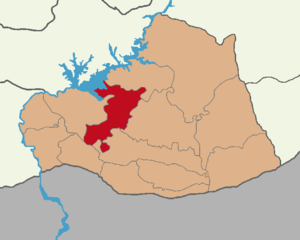
Karaköprü
District and municipality in Şanlıurfa, Turkey
Distance: Approx. 2588 meters
Latitude and longitude: 37.1847,38.7908
Karaköprü (Kurdish: Pira Reş) is a municipality and district of Şanlıurfa Province, Turkey. Its area is 1,222 km2, and its population is 265,035 (2022). The district Karaköprü was created at the 2013 reorganisation from part of the former central district of Şanlıurfa Province, along with the new districts Eyyübiye and Haliliye.
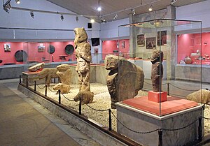
Şanlıurfa Archaeology and Mosaic Museum
Distance: Approx. 6123 meters
Latitude and longitude: 37.15361111,38.78166667
Şanlıurfa Archaeology and Mosaic Museums or Şanlıurfa Museum (Turkish: Şanlıurfa Müzesi) are located in the south-eastern city of Şanlıurfa (also known as Urfa), Turkey. The museums contain remains of Şanlıurfa (known as Edessa in antiquity), Göbekli Tepe, Karahan Tepe, Harran (another ancient city which lies 44 kilometres (27 mi) southeast of Şanlıurfa), findings from the Southeastern Anatolia Project and ruins found in the hydroelectric dam reservoirs of Atatürk Dam, Birecik Dam and Karkamış Dam. Both museums are located at Haleplibahçe Mahallesi 2372, Sok Eyyübiye/Şanlıurfa (across the Şanlıurfa Piazza Mall).

Urfa Sanjak
Sanjak of the Ottoman Empire
Distance: Approx. 5405 meters
Latitude and longitude: 37.15833333,38.79166667
The Urfa Sanjak (Turkish: Urfa Sancağı), previously known as Sanjak of Birejik, was a prefecture (sanjak) of the Ottoman Empire, located in modern-day Turkey and Syria. The city of Urfa was the Sanjak's capital.
Siege of Edessa (544)
544 AD siege of Byzantine Edessa by the Sasanian Empire
Distance: Approx. 6258 meters
Latitude and longitude: 37.15,38.8
The siege of Edessa (then known as Justinopolis) occurred in 544 AD during an invasion of the Byzantine Empire ruled by Justinian I by the Sasanian Empire under Khosrow I in the midst of the ongoing Lazic War in the north. The city withstood the fierce siege. Due to the religious nature of the city, some Christian traditions have attributed the result of the conflict to divine intervention.
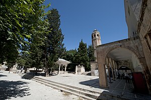
Grand Mosque of Urfa
Mosque in Urfa, Turkey
Distance: Approx. 6215 meters
Latitude and longitude: 37.15119,38.7899
The 12th-century Grand Mosque of Urfa is a congregational mosque in Urfa, Turkey. It was probably built on the site of an earlier Christian church, in this case possibly one dedicated to St. Stephen.: 20 The exact circumstances of the mosque's foundation are unknown — it may represent an expansion of an earlier mosque.
Weather in this IP's area
scattered clouds
24 Celsius
24 Celsius
24 Celsius
24 Celsius
1008 hPa
64 %
1008 hPa
943 hPa
10000 meters
1.58 m/s
2.41 m/s
138 degree
42 %
06:01:24
18:43:47