Country:
 Turkey
Region:
City:
Latitude and Longitude:
Time Zone:
Postal Code:
IP information under different IP Channel
ip-api
Country
Region
City
ASN
Time Zone
ISP
Blacklist
Proxy
Latitude
Longitude
Postal
Route
IPinfo
Country
Region
City
ASN
Time Zone
ISP
Blacklist
Proxy
Latitude
Longitude
Postal
Route
MaxMind
Country
Region
City
ASN
Time Zone
ISP
Blacklist
Proxy
Latitude
Longitude
Postal
Route
Luminati
Country
TRASN
Time Zone
Europe/Istanbul
ISP
Vodafone Net Iletisim Hizmetler AS
Latitude
Longitude
Postal
db-ip
Country
Region
City
ASN
Time Zone
ISP
Blacklist
Proxy
Latitude
Longitude
Postal
Route
ipdata
Country
Region
City
ASN
Time Zone
ISP
Blacklist
Proxy
Latitude
Longitude
Postal
Route
Popular places and events near this IP address

Istanbul Park
Race track in Istanbul, Turkey
Distance: Approx. 7058 meters
Latitude and longitude: 40.95166667,29.405
Istanbul Park (Turkish: İstanbul Park), also known as the Istanbul Racing Circuit or initially as the Istanbul Otodrom, is a motor sports race track in the Tuzla district of Istanbul, Turkey. Designed by Hermann Tilke, it opened on 19–21 August 2005. It has been called "the best race track in the world" by former Formula One Chief Executive Bernie Ecclestone, who held the managing rights of the circuit between 2007 and 2011.
Turkish motorcycle Grand Prix
Motor race
Distance: Approx. 7058 meters
Latitude and longitude: 40.95166667,29.405
The Turkish motorcycle Grand Prix was a motorcycling event that was part of the World Motorcycle Racing season. The races were held in Istanbul Park in Istanbul, İzmit Körfez Circuit in Kocaeli Province and Pınarbaşı Racing Circuit in İzmir.
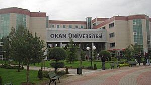
Istanbul Okan University
Private university in İstanbul, Turkey
Distance: Approx. 6581 meters
Latitude and longitude: 40.95194444,29.3925
Istanbul Okan University is a private university in Istanbul, Turkey.
2009 Turkish Grand Prix
Motor car race
Distance: Approx. 7058 meters
Latitude and longitude: 40.95166667,29.405
The 2009 Turkish Grand Prix (officially the 2009 Formula 1 ING Turkish Grand Prix) was the seventh motor race of the 2009 FIA Formula One World Championship. It was held on 7 June 2009 at Istanbul Park, Tuzla, Turkey. The race was won by Jenson Button, with Mark Webber and Sebastian Vettel of Red Bull Racing completing the podium.

Sabiha Gökçen International Airport
Secondary airport serving Istanbul, Turkey
Distance: Approx. 4269 meters
Latitude and longitude: 40.89833333,29.30916667
Istanbul Sabiha Gökçen International Airport (IATA: SAW, ICAO: LTFJ) is an international airport serving Istanbul, Turkey. Located 32 km (20 mi) southeast of the city center, Sabiha Gökçen Airport is in the Asian part of the transcontinental city and serves as the operating base for AJet and Pegasus Airlines. The airport is named after Sabiha Gökçen, adoptive daughter of Mustafa Kemal Atatürk and the first female fighter pilot in the world.
Sabancı University
Private university in İstanbul, Turkey
Distance: Approx. 1774 meters
Latitude and longitude: 40.89054722,29.37838611
Sabancı University (Turkish: Sabancı Üniversitesi), established in 1994, is a young foundation university located on a 1.26 million squaremeter campus which is about 40 km from Istanbul's city center. Its first students matriculated in 1999. The first academic session started on October 20, 1999 (1999-10-20T+2:00).

Kurtköy High School
Public, anatolian high school in Kurtköy, Pendik, İstanbul, Turkey
Distance: Approx. 5584 meters
Latitude and longitude: 40.913119,29.296535
Kurtköy High School (Turkish: Kurtköy Anadolu Lisesi) is a secondary public anatolian school located in Pendik, Istanbul, Turkey.

2015 Sabiha Gökçen Airport bombing
Terrorist attack in Istanbul, Turkey
Distance: Approx. 4269 meters
Latitude and longitude: 40.89833333,29.30916667
The Sabiha Gökçen Airport bombing took place on 23 December 2015 in the apron area of Sabiha Gökçen International Airport in Istanbul, Turkey. The explosion, which occurred at approximately 02:05 local time, wounded two airport cleaners, one of whom later died after being taken to hospital. Flights from the terminal resumed as normal while Binali Yıldırım, the Minister of Transport, Maritime and Communication, claimed that there had been no security lapses at the airport.
Pegasus Airlines Flight 2193
February 2020 runway overrun incident in Istanbul, Turkey
Distance: Approx. 2930 meters
Latitude and longitude: 40.9055063,29.3264491
Pegasus Airlines Flight 2193 was a scheduled domestic passenger flight from Izmir to Istanbul in Turkey operated by Pegasus Airlines. On 5 February 2020, the Boeing 737-800 operating the route skidded off the runway while landing at Istanbul-Sabiha Gökçen International Airport, Turkey. Three people were killed, 179 people were injured, and the aircraft was destroyed.

Kurtköy, Pendik
Neighbourhood in Pendik, Istanbul, Turkey
Distance: Approx. 5410 meters
Latitude and longitude: 40.91416667,29.29916667
Kurtköy is a neighbourhood in the municipality and district of Pendik, Istanbul Province, Turkey. Its population is 37,801 (2022). Before 1987, when the district of Pendik was established, it was a neighbourhood of Kartal.

Sabiha Gökçen Havalimanı (Istanbul Metro)
Station of the Istanbul Metro
Distance: Approx. 4144 meters
Latitude and longitude: 40.906667,29.311944
Sabiha Gökçen Havalimanı (Sabiha Gökçen Airport) is an underground rapid transit station on the M4 line of the Istanbul Metro. It is located in the Sanayi neighborhood of Pendik, serving Sabiha Gökçen International Airport. It was opened on 2 October 2022 with the extension of M4 line from Tavşantepe, and is the eastern terminus of the line.

Kurtköy (Istanbul Metro)
Station of the Istanbul Metro
Distance: Approx. 5511 meters
Latitude and longitude: 40.909444,29.296111
Kurtköy is an underground rapid transit station on the M4 line of the Istanbul Metro. It is located on Ankara Street in the Kurtköy neighborhood of Pendik. It was opened on 2 October 2022 with the extension of M4 line from Tavşantepe to Sabiha Gökçen Airport.
Weather in this IP's area
scattered clouds
15 Celsius
14 Celsius
13 Celsius
15 Celsius
1026 hPa
51 %
1026 hPa
1013 hPa
10000 meters
7.2 m/s
20 degree
40 %
07:17:12
18:17:48