Country:
Region:
City:
Latitude and Longitude:
Time Zone:
Postal Code:
IP information under different IP Channel
ip-api
Country
Region
City
ASN
Time Zone
ISP
Blacklist
Proxy
Latitude
Longitude
Postal
Route
Luminati
Country
ASN
Time Zone
Europe/Warsaw
ISP
DevonStudio Sp. z o.o.
Latitude
Longitude
Postal
IPinfo
Country
Region
City
ASN
Time Zone
ISP
Blacklist
Proxy
Latitude
Longitude
Postal
Route
db-ip
Country
Region
City
ASN
Time Zone
ISP
Blacklist
Proxy
Latitude
Longitude
Postal
Route
ipdata
Country
Region
City
ASN
Time Zone
ISP
Blacklist
Proxy
Latitude
Longitude
Postal
Route
Popular places and events near this IP address

Powiśle, Warsaw
Neighborhood in Warsaw, Poland
Distance: Approx. 394 meters
Latitude and longitude: 52.2374,21.0295
Powiśle (Polish pronunciation: [pɔˈviɕlɛ]; literally along-the-Vistula) is a neighbourhood in Warsaw's borough of Śródmieście (Downtown). It is located between the Vistula river and its escarpment. Historically, it is composed of three neighbourhoods: central Powiśle, Mariensztat to the north (just below the Warsaw's Old Town) and Solec to the south.

Warsaw National Museum
National museum in Warsaw, Poland
Distance: Approx. 594 meters
Latitude and longitude: 52.23166667,21.02472222
The Warsaw National Museum (Polish: Muzeum Narodowe w Warszawie, MNW), also known as the National Museum in Warsaw, is a national museum in Warsaw, one of the largest museums in Poland and the largest in the capital. It comprises a rich collection of ancient art (Egyptian, Greek, Roman), counting about 11,000 pieces, an extensive gallery of Polish painting since the 16th century and a collection of foreign painting (Italian, French, Flemish, Dutch, German and Russian) including some paintings from Adolf Hitler's private collection, ceded to the museum by the American authorities in post-war Germany. The museum is also home to numismatic collections, a gallery of applied arts and a department of oriental art, with the largest collection of Chinese art in Poland, comprising some 5,000 objects.

Polish Army Museum
Distance: Approx. 513 meters
Latitude and longitude: 52.23194444,21.02583333
Museum of the Polish Army (Polish: Muzeum Wojska Polskiego) is a museum in Warsaw documenting the military history of Poland. Established in 1920 under the Second Polish Republic, it formerly occupied a wing of the building of the Polish National Museum and now occupies a building of its own at the Warsaw Citadel, as well as several branches in Poland. It is Warsaw's second largest museum and the largest collection of military objects in Poland.

Tamka Street, Warsaw
Street in Warsaw
Distance: Approx. 533 meters
Latitude and longitude: 52.23722222,21.02611111
Tamka Street, ulica Tamka in Polish, is a street in the Powiśle district of Warsaw, Poland. The street runs downhill from central Warsaw toward the Vistula River and connects ulica Świętokrzyska with the Świętokrzyski Bridge. The street's name originates from a small dam (Polish: tama) that once dammed a stream that formerly flowed along the course of the present street.

Foksal Gallery
Distance: Approx. 593 meters
Latitude and longitude: 52.23444444,21.02361111
The Foksal Gallery or Galeria Foksal is a non-commercial gallery space in Warsaw, Poland established in 1966, that shows works by contemporary avant-garde artists.

Asia and Pacific Museum
Distance: Approx. 363 meters
Latitude and longitude: 52.23305556,21.03722222
The Asia and Pacific Museum (Polish: Muzeum Azji i Pacyfiku), in Warsaw, Poland, was founded in 1973 from a private collection of Oriental art amassed by Andrzej Wawrzyniak, sailor, diplomat, and connoisseur–collector of Oriental art. After returning to Poland, he donated his collection, numbering over 3,000 objects, to Poland. Thus the Museum of the Nusantara Archipelago was created in Warsaw in 1973.

Warszawa Powiśle railway station
Railway station in Warsaw, Poland
Distance: Approx. 318 meters
Latitude and longitude: 52.233611,21.027778
Warszawa Powiśle, in English Warsaw Powiśle, is an urban railway station in Warsaw, Poland. Located in the neighborhood of Powiśle in borough of Śródmieście (Downtown), stretching between Aleje Jerozolimskie near Rondo Charles'a de Gaulle'a (high-level entrance), and the intersection of Aleja 3 Maja and ul. Kruczkowskiego (low-level entrance).
Faras Gallery at the National Museum in Warsaw
Gallery in Warsaw, Poland
Distance: Approx. 594 meters
Latitude and longitude: 52.23166667,21.02472222
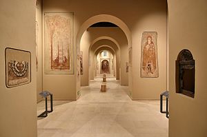
The Professor Kazimierz Michałowski Faras Gallery at the National Museum in Warsaw is a permanent gallery at the National Museum in Warsaw, presenting Nubian early Christian art. The Gallery features a unique collection of wall paintings and architectural elements from the Faras Cathedral, discovered by an archeological expedition led by Professor Kazimierz Michałowski.

Konstanty Zamoyski Palace
Historic site in Mazowsze Province, Poland
Distance: Approx. 574 meters
Latitude and longitude: 52.23444444,21.02388889
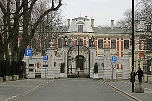
The Konstanty Zamoyski Palace (Polish: Pałac Konstantego Zamoyskiego; Pałac Zamoyskich) is a historic building on ulica Foksal in Warsaw, Poland.

General Maria Wittek Monument
Monument in Warsaw, Poland
Distance: Approx. 537 meters
Latitude and longitude: 52.23180556,21.02555556
The General Maria Wittek Monument is a monument in Warsaw, Poland, placed at the courtyard of the Warsaw National Museum at 3 Jerusalem Avenue. It is dedicated to Maria Wittek, veteran of the First and Second World Wars, and the first woman to receive rank of brigadier general in the Polish Armed Forces. The monument was designed by Jan Bohdan Chmielewski and unveiled on 19 April 2007.

Karol Beyer Park
Urban park in Warsaw, Poland
Distance: Approx. 309 meters
Latitude and longitude: 52.23441667,21.02777778
The Karol Beyer Park is an urban park in Warsaw, Poland, within the Downtown district. It is located on the Warsaw Escarpment, between Smolna Street, Kruczewskiego Street, Warsaw Cross-City Line, and Warszawa Powiśle railway station. The park was opened in the 1970s.

Janina Porazińska Park
Urban park in Warsaw, Poland
Distance: Approx. 231 meters
Latitude and longitude: 52.23241,21.03371
Janina Porazińska Park is an urban park in Warsaw, Poland. It is located in the neighbourhood of Solec in the Downtown district, between Kruczkowskiego, Solec, and Ludna Streets, and Trzeciego Maja Avenue. The park was opened in 2011.
Weather in this IP's area
few clouds
3 Celsius
-2 Celsius
3 Celsius
4 Celsius
1006 hPa
86 %
1006 hPa
996 hPa
10000 meters
6.71 m/s
260 degree
20 %
07:02:25
15:40:05
