Country:
 Germany
Region:
City:
Latitude and Longitude:
Time Zone:
Postal Code:
IP information under different IP Channel
ip-api
Country
Region
City
ASN
Time Zone
ISP
Blacklist
Proxy
Latitude
Longitude
Postal
Route
IPinfo
Country
Region
City
ASN
Time Zone
ISP
Blacklist
Proxy
Latitude
Longitude
Postal
Route
MaxMind
Country
Region
City
ASN
Time Zone
ISP
Blacklist
Proxy
Latitude
Longitude
Postal
Route
Luminati
Country
 NL
NLASN
Time Zone
Europe/Amsterdam
ISP
ATGS-MMD-AS
Latitude
Longitude
Postal
db-ip
Country
Region
City
ASN
Time Zone
ISP
Blacklist
Proxy
Latitude
Longitude
Postal
Route
ipdata
Country
Region
City
ASN
Time Zone
ISP
Blacklist
Proxy
Latitude
Longitude
Postal
Route
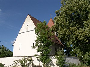
Popular places and events near this IP address
Geiselwind
Municipality in Bavaria, Germany
Distance: Approx. 9797 meters
Latitude and longitude: 49.76666667,10.46666667
Geiselwind is a market town in Lower Franconia (Bavaria) in the district of Kitzingen in Germany. It has a population of around 2,300.

Scheinfeld
Town in Bavaria, Germany
Distance: Approx. 7516 meters
Latitude and longitude: 49.66666667,10.46666667
Scheinfeld is a town in the Neustadt (Aisch)-Bad Windsheim district, in Bavaria, Germany. It is situated 14 km northwest of Neustadt (Aisch), and 40 km east of Würzburg. Schloss Schwarzenberg is adjacent to the town.

Schlüsselfeld
Town in Bavaria, Germany
Distance: Approx. 8513 meters
Latitude and longitude: 49.76666667,10.61666667
Schlüsselfeld is a town on the southwestern edge of the Upper Franconian district (Landkreis) of Bamberg

Münchsteinach
Municipality in Bavaria, Germany
Distance: Approx. 9548 meters
Latitude and longitude: 49.61666667,10.58333333
Münchsteinach is a municipality in the district of Neustadt (Aisch)-Bad Windsheim in Middle Franconia, Bavaria, Germany. It is famous for being near the factory for club-mate.
Vestenbergsgreuth
Municipality in Bavaria, Germany
Distance: Approx. 5740 meters
Latitude and longitude: 49.66666667,10.61666667
Vestenbergsgreuth is a municipality in the district of Erlangen-Höchstadt, in Bavaria, Germany.

Baudenbach
Municipality in Bavaria, Germany
Distance: Approx. 9791 meters
Latitude and longitude: 49.61666667,10.51666667
Baudenbach is a municipality in the district of Neustadt (Aisch)-Bad Windsheim in Bavaria in Germany.

Burghaslach
Municipality in Bavaria, Germany
Distance: Approx. 2609 meters
Latitude and longitude: 49.71666667,10.58333333
Burghaslach is a municipality and a market town in the district of Neustadt (Aisch)-Bad Windsheim in Franconia in Bavaria, Germany.

Langenfeld, Bavaria
Municipality in Bavaria, Germany
Distance: Approx. 9791 meters
Latitude and longitude: 49.61666667,10.51666667
Langenfeld is a municipality in the district of Neustadt (Aisch)-Bad Windsheim in Bavaria in Germany.
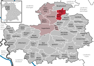
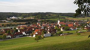
Markt Taschendorf
Municipality in Bavaria, Germany
Distance: Approx. 496 meters
Latitude and longitude: 49.7,10.55
Markt Taschendorf is a municipality in the district of Neustadt (Aisch)-Bad Windsheim in Bavaria in Germany.

Breitenlohe
Distance: Approx. 3972 meters
Latitude and longitude: 49.714,10.608
Breitenlohe is a part of the city Burghaslach, Bavaria, Germany. Breitenlohe has about 100 inhabitants and is part of the administrative district Landkreis Neustadt an der Aisch-Bad Windsheim.

Ebrach (Reiche Ebrach)
River in Bavaria, Germany
Distance: Approx. 8408 meters
Latitude and longitude: 49.7698,10.5096
The Ebrach (also: Geiselwinder Ebrach) is a river of Bavaria, Germany. The Ebrach springs from the confluence of the Ebrachbach and the Haselbach in Geiselwind. It discharges west of Geiselwind from the right into the Reiche Ebrach.
Weather in this IP's area
overcast clouds
13 Celsius
12 Celsius
12 Celsius
14 Celsius
1015 hPa
88 %
1015 hPa
974 hPa
10000 meters
3.38 m/s
5.06 m/s
93 degree
100 %
07:44:12
18:21:12