Country:
 Germany
Region:
City:
Latitude and Longitude:
Time Zone:
Postal Code:
IP information under different IP Channel
ip-api
Country
Region
City
ASN
Time Zone
ISP
Blacklist
Proxy
Latitude
Longitude
Postal
Route
IPinfo
Country
Region
City
ASN
Time Zone
ISP
Blacklist
Proxy
Latitude
Longitude
Postal
Route
MaxMind
Country
Region
City
ASN
Time Zone
ISP
Blacklist
Proxy
Latitude
Longitude
Postal
Route
Luminati
Country
 NL
NLASN
Time Zone
Europe/Amsterdam
ISP
ATGS-MMD-AS
Latitude
Longitude
Postal
db-ip
Country
Region
City
ASN
Time Zone
ISP
Blacklist
Proxy
Latitude
Longitude
Postal
Route
ipdata
Country
Region
City
ASN
Time Zone
ISP
Blacklist
Proxy
Latitude
Longitude
Postal
Route
Popular places and events near this IP address

Waldsassen
Town in Bavaria, Germany
Distance: Approx. 7125 meters
Latitude and longitude: 50,12.3
Waldsassen (German pronunciation: [valtˈzasn̩] ; Northern Bavarian: Woidsassen) is a town in the district of Tirschenreuth in the Upper Palatinate region of Bavaria.

Waldsassen Abbey
Distance: Approx. 7862 meters
Latitude and longitude: 50.00388889,12.30944444
Waldsassen Abbey (German: Abtei Waldsassen) is a Cistercian nunnery, formerly a Cistercian monastery, located on the River Wondreb at Waldsassen near Tirschenreuth, Oberpfalz, in Bavaria, Germany, close to the border with the Czech Republic. In the Holy Roman Empire it was an Imperial Abbey.

Mitterteich
Town in Bavaria, Germany
Distance: Approx. 1699 meters
Latitude and longitude: 49.93333333,12.23333333
Mitterteich (Northern Bavarian: Miederdeich) is a municipality in the district of Tirschenreuth, in Bavaria, Germany. It is situated 10 km northwest of Tirschenreuth, and 17 km southwest of Cheb.

Fuchsmühl
Municipality in Bavaria, Germany
Distance: Approx. 7631 meters
Latitude and longitude: 49.91666667,12.15
Fuchsmühl is a municipality in the district of Tirschenreuth in Bavaria, Germany.

Wiesau
Municipality in Bavaria, Germany
Distance: Approx. 6573 meters
Latitude and longitude: 49.91666667,12.16666667
Wiesau is a municipality in the district of Tirschenreuth in Bavaria, Germany.
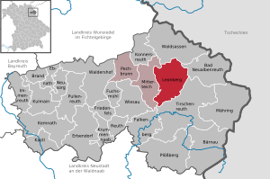
Leonberg, Bavaria
Municipality in Bavaria, Germany
Distance: Approx. 2700 meters
Latitude and longitude: 49.95,12.28333333
Leonberg is a municipality in the district of Tirschenreuth in Bavaria, Germany.

Pechbrunn
Municipality in Bavaria, Germany
Distance: Approx. 6128 meters
Latitude and longitude: 49.96666667,12.16666667
Pechbrunn is a municipality in the district of Tirschenreuth in Bavaria, Germany.

Reichsforst (Fichtel)
Distance: Approx. 5006 meters
Latitude and longitude: 49.98,12.2
The Reichsforst ("Imperial Forest") is a wooded area in the southeastern part of the Fichtel Mountains of southern Germany. It lies in the districts of Tirschenreuth and Wunsiedel (northeastern Bavaria), and between the Wondreb and Röslau troughs. It is also the largest contiguous basalt region of the Fichtelgebirge with an area of 26 square kilometres (10 sq mi).

Teichelberg
Mountain in Germany
Distance: Approx. 6012 meters
Latitude and longitude: 49.95746,12.164011
Teichelberg is a mountain in the Fichtel Mountains in Bavaria, Germany. Mining of a 45-meter thick basalt layer started in 1888.
Wiesau (river)
River in Germany
Distance: Approx. 7348 meters
Latitude and longitude: 49.8802,12.248
Wiesau is a river of Bavaria, Germany. It passes through the town Wiesau and flows into the Waldnaab near Falkenberg.
Seibertsbach
River in Germany
Distance: Approx. 2043 meters
Latitude and longitude: 49.9574,12.2687
Seibertsbach is a river of Bavaria, Germany. It flows into the Wondreb near Mitterteich.

Stiftsbasilika Waldsassen
Parish church in Waldsassen, Bavaria
Distance: Approx. 7862 meters
Latitude and longitude: 50.00388889,12.30944444
The Waldsassen Basilica, Mariä Himmelfahrt und St. Johannes Evangelist (Assumption of Mary and St. John the Evangelist) is the parish church in Waldsassen, Bavaria.
Weather in this IP's area
broken clouds
12 Celsius
12 Celsius
12 Celsius
14 Celsius
1012 hPa
91 %
1012 hPa
952 hPa
10000 meters
0.7 m/s
0.67 m/s
82 degree
62 %
06:37:03
19:40:32