Country:
 Great Britain
Region:
City:
Latitude and Longitude:
Time Zone:
Postal Code:
IP information under different IP Channel
ip-api
Country
Region
City
ASN
Time Zone
ISP
Blacklist
Proxy
Latitude
Longitude
Postal
Route
IPinfo
Country
Region
City
ASN
Time Zone
ISP
Blacklist
Proxy
Latitude
Longitude
Postal
Route
MaxMind
Country
Region
City
ASN
Time Zone
ISP
Blacklist
Proxy
Latitude
Longitude
Postal
Route
Luminati
Country
 NL
NLASN
Time Zone
Europe/Amsterdam
ISP
ATGS-MMD-AS
Latitude
Longitude
Postal
db-ip
Country
Region
City
ASN
Time Zone
ISP
Blacklist
Proxy
Latitude
Longitude
Postal
Route
ipdata
Country
Region
City
ASN
Time Zone
ISP
Blacklist
Proxy
Latitude
Longitude
Postal
Route
Popular places and events near this IP address
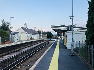
Berwick railway station (East Sussex)
Railway station in East Sussex, England
Distance: Approx. 3765 meters
Latitude and longitude: 50.84,0.166
Berwick railway station is located in Berwick, East Sussex, England. Berwick village is located nearby to the south of the A27 road. The station is on the East Coastway Line, 57 miles 47 chains (92.7 km) from London Bridge, and train services are provided by Southern.

Firle
Village in East Sussex, England
Distance: Approx. 3796 meters
Latitude and longitude: 50.84,0.12
Firle (; Sussex dialect: Furrel ) is a village and civil parish in the Lewes district of East Sussex, England. Firle refers to an old-English/Anglo-Saxon word fierol meaning overgrown with oak. Although the original division of East Firle and West Firle still remains, East Firle is now simply confined to the houses of Heighton Street, which lie to the east of the Firle Park.

Charleston Farmhouse
Historic house museum
Distance: Approx. 3768 meters
Latitude and longitude: 50.84215278,0.11469722
Charleston, in East Sussex, is a property associated with the Bloomsbury group, that is open to the public. It was the country home of Vanessa Bell and Duncan Grant and is an example of their decorative style within a domestic context, representing the fruition of more than sixty years of artistic creativity. In addition to the house and artists' garden, Charleston hosts a year-round programme of Bloomsbury and contemporary exhibitions in a suite of galleries designed by Jamie Fobert Architects which opened in September 2018.

Laughton, East Sussex
Village in East Sussex, England
Distance: Approx. 3397 meters
Latitude and longitude: 50.9,0.13
Laughton is a village and civil parish in the Wealden district of East Sussex, England. The village is located five miles (8 km) east of Lewes, at a junction on the minor road to Hailsham (B2124). It appears in the Domesday Book, and there are Roman remains nearby.

Selmeston
Village in East Sussex, England
Distance: Approx. 3426 meters
Latitude and longitude: 50.84,0.14
Selmeston is a village and civil parish in the Wealden District of East Sussex, England. It is located eight miles (13 km) east of Lewes, to the north of the A27 road between there and Polegate. The church existed at the time of its mention in the Domesday Book of 1086; it is dedicated to St Mary.

Laughton Place
Distance: Approx. 2893 meters
Latitude and longitude: 50.8833,0.1075
Laughton Place is a historic building near Lewes, Sussex owned by the Landmark Trust. The Pelham family bought Laughton Place, an old fortified manor, in 1466; it was rebuilt in 1534 by William Pelham. Laughton Tower was restored under the supervision of architect John Warren in the 1980s.

Chalvington with Ripe
Parish in East Sussex, England
Distance: Approx. 1299 meters
Latitude and longitude: 50.864436,0.159125
The civil parish of Chalvington with Ripe, in the Wealden District of East Sussex, England, is made up of the two villages, Chalvington and Ripe. They are located in the upper Rivers Cuckmere and Ouse joint valley north of the South Downs, between the A27 and the A22 roads, and some 15 miles (24 km) north-west of Eastbourne. Ripe is the larger of the two ecclesiastical parishes with 1,120 acres (450 hectares), compared to the 729 acres (295 hectares) of Chalvington.
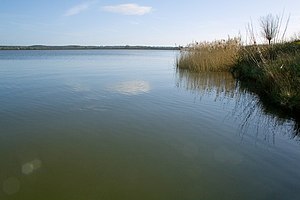
Arlington Reservoir
Protected area in East Sussex, England
Distance: Approx. 3795 meters
Latitude and longitude: 50.845,0.179
Arlington Reservoir is a 100.4-hectare (248-acre) biological Site of Special Scientific Interest west of Hailsham in East Sussex, England. It is also a Local Nature Reserve and it is owned and managed by South East Water.

Burgh Hill Farm Meadow
Distance: Approx. 3848 meters
Latitude and longitude: 50.894,0.184
Burgh Hill Farm Meadow is a 0.9-hectare (2.2-acre) biological Site of Special Scientific Interest west of Hailsham in East Sussex. This meadow is managed to encourage wildlife and 67 species of flowering plants have been recorded, such as yellow rattle, pepper saxifrage and green winged orchid. The site also has a ditch, two small ponds and mature hedgerows.
Broyle Place
Distance: Approx. 4149 meters
Latitude and longitude: 50.8957,0.0997
Broyle Place is a historic house in Sussex, England. It is a Grade II listed Elizabethan manor house. In the 12th century, it belonged to Theobald, Archbishop of Canterbury.

Golden Cross, East Sussex
Village in East Sussex, England
Distance: Approx. 3677 meters
Latitude and longitude: 50.89083,0.18503018
Golden Cross is a small village in the Wealden district of East Sussex, England. Its nearest town is Hailsham, which lies approximately 3+1⁄2 miles (6 kilometres) southeast of the village. The village lies on the A22 road in the parish of Chiddingly.
RAF Deanland
Distance: Approx. 1266 meters
Latitude and longitude: 50.88055556,0.1525
RAF Deanland is a former Royal Air Force advanced landing ground located 4 miles (6.4 km) west of Hailsham, East Sussex and 13.4 miles (21.6 km) north east of Brighton, East Sussex, England
Weather in this IP's area
few clouds
14 Celsius
13 Celsius
12 Celsius
16 Celsius
1016 hPa
89 %
1016 hPa
1014 hPa
10000 meters
0.45 m/s
1.79 m/s
345 degree
11 %
07:27:47
18:00:55