Country:
 Great Britain
Region:
City:
Latitude and Longitude:
Time Zone:
Postal Code:
IP information under different IP Channel
ip-api
Country
Region
City
ASN
Time Zone
ISP
Blacklist
Proxy
Latitude
Longitude
Postal
Route
IPinfo
Country
Region
City
ASN
Time Zone
ISP
Blacklist
Proxy
Latitude
Longitude
Postal
Route
MaxMind
Country
Region
City
ASN
Time Zone
ISP
Blacklist
Proxy
Latitude
Longitude
Postal
Route
Luminati
Country
 NL
NLASN
Time Zone
Europe/Amsterdam
ISP
ATGS-MMD-AS
Latitude
Longitude
Postal
db-ip
Country
Region
City
ASN
Time Zone
ISP
Blacklist
Proxy
Latitude
Longitude
Postal
Route
ipdata
Country
Region
City
ASN
Time Zone
ISP
Blacklist
Proxy
Latitude
Longitude
Postal
Route
Popular places and events near this IP address

East Croydon station
National rail station and Tramlink tram stop in London
Distance: Approx. 78 meters
Latitude and longitude: 51.3752,-0.0923
East Croydon is a railway station, tram stop and associated bus station in Croydon, Greater London, England. It is located in Travelcard Zone 5. At 10 miles 28 chains (10.35 mi; 16.66 km) from London Bridge, it is the 20th busiest station in Britain, was the 10th busiest in 2020–21 (due to the COVID pandemic), is the busiest national rail station in London outside of fare zones 1 and 2 and is one of the busiest non-terminal stations in the country.
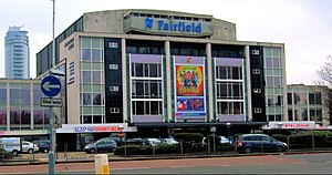
Fairfield Halls
Concert hall in Croydon, United Kingdom
Distance: Approx. 356 meters
Latitude and longitude: 51.37222222,-0.09583333
Fairfield Halls is an arts, entertainment and conference centre in Croydon, London, England, which opened in 1962 and contains a theatre and gallery, and a large concert hall regularly used for BBC television, radio and orchestral recordings. Fairfield Halls closed for a £30 million redevelopment in 2016, and reopened in 2019. As part of the building's re-opening Talawa Theatre Company relocated to the building, taking up a 200-seat theatre space and offices.

Ruskin Square
Distance: Approx. 211 meters
Latitude and longitude: 51.376,-0.0941
Ruskin Square (or Croydon Gateway) is a project to redevelop a parcel of land between East Croydon railway station and the existing town centre of Croydon in South London. It is part of the major Croydon Vision 2020 regeneration scheme. It has been subject to substantial public debate which has featured in the national media.

Croydon College
College in London, England
Distance: Approx. 222 meters
Latitude and longitude: 51.3735,-0.095
Croydon College is a large further and higher education college located in Croydon, within the London Borough of Croydon. Its origins can be traced to a School of Art that was established in 1868, which subsequently merged with Croydon Polytechnic to create the college shortly after the Second World War. The college provides study programmes, apprenticeships and higher education courses at Croydon University Centre to over 10,000 enrolled students as of 2014, of which 3,400 are full-time.

Croydon Underpass
Underpass in Croydon, London
Distance: Approx. 320 meters
Latitude and longitude: 51.3741,-0.0968
Croydon Underpass is an underpass located in Croydon, London, England. The road is part of the A212 which stretches from Catford to Forestdale. The underpass was constructed beneath the junction of George Street and Wellesley Road/Park Lane in the early 1960s.

Ashcroft Theatre
Distance: Approx. 333 meters
Latitude and longitude: 51.3722,-0.0953
The Ashcroft Theatre is a theatre located within the Fairfield Halls, Croydon, South London. The theatre was named after Croydon-born Dame Peggy Ashcroft and is a proscenium theatre with a stepped auditorium. The mural on its fire curtain is by the artist Henry Bird.

Wettern House
Distance: Approx. 214 meters
Latitude and longitude: 51.3758,-0.0945
Wettern House was a high rise building next to East Croydon station in Croydon. Originally built in 1963, two years before the County Borough of Croydon disbanded into the London Borough of Croydon, it was demolished in November 2005 to make way for what would become Ruskin Square. Before demolition, the building had 12 floors and a structural height of 38 metres (125 ft).

No. 1 Croydon
Tall building in Croydon, London
Distance: Approx. 97 meters
Latitude and longitude: 51.3749,-0.091
No. 1 Croydon (formerly the NLA Tower, and colloquially the 50p Building, the Weddingcake or the Threepenny bit building) is a tall building at 12–16 Addiscombe Road, Croydon, Greater London, next to East Croydon station. It was designed by Richard Seifert & Partners and completed in 1970.

Nestlé Tower
Distance: Approx. 372 meters
Latitude and longitude: 51.3731,-0.0971
St George's House (also known as the Nestlé Tower or Nestlé Block) is a 79-metre (259 ft) office tower located in Croydon, United Kingdom. It was occupied by the Swiss multinational food and consumer goods company Nestlé as the headquarters of Nestlé UK & Ireland until September 2012.

Altitude 25
Distance: Approx. 230 meters
Latitude and longitude: 51.3725,-0.09138889
Altitude 25 is an apartment building on Fairfield Road in the London Borough of Croydon, London. It is Croydon's fourth tallest building. The development was intended to regenerate a brownfield site near to East Croydon station.

Warehouse Theatre
Distance: Approx. 117 meters
Latitude and longitude: 51.3749,-0.0938
The Warehouse Theatre was a professional producing theatre in the centre of Croydon, England. Based in an oak-beamed Victorian former cement warehouse, it had 100 seats. The theatre closed in 2012 following withdrawal of funding and the discovery, after a survey, of serious faults in the building.

Croydon Law Courts
Judicial building in Croydon, England
Distance: Approx. 178 meters
Latitude and longitude: 51.3729,-0.0922
Croydon Law Courts is a Crown Court venue, which deals with criminal cases, and a County Court venue, which deals with civil cases, in Altyre Road, Croydon, London. There is also an older magistrates' courts building on an adjacent site in Barclay Road.
Weather in this IP's area
mist
11 Celsius
10 Celsius
10 Celsius
12 Celsius
1016 hPa
88 %
1016 hPa
1008 hPa
4100 meters
2.57 m/s
230 degree
100 %
07:29:34
18:01:01