Country:
 Great Britain
Region:
City:
Latitude and Longitude:
Time Zone:
Postal Code:
IP information under different IP Channel
ip-api
Country
Region
City
ASN
Time Zone
ISP
Blacklist
Proxy
Latitude
Longitude
Postal
Route
IPinfo
Country
Region
City
ASN
Time Zone
ISP
Blacklist
Proxy
Latitude
Longitude
Postal
Route
MaxMind
Country
Region
City
ASN
Time Zone
ISP
Blacklist
Proxy
Latitude
Longitude
Postal
Route
Luminati
Country
 NL
NLASN
Time Zone
Europe/Amsterdam
ISP
ATGS-MMD-AS
Latitude
Longitude
Postal
db-ip
Country
Region
City
ASN
Time Zone
ISP
Blacklist
Proxy
Latitude
Longitude
Postal
Route
ipdata
Country
Region
City
ASN
Time Zone
ISP
Blacklist
Proxy
Latitude
Longitude
Postal
Route
Popular places and events near this IP address
Redditch
Town and borough in England
Distance: Approx. 1109 meters
Latitude and longitude: 52.3,-1.933333
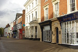
Redditch is a town and non-metropolitan district with borough status in Worcestershire, England. It is located south of Birmingham, east of Bromsgrove, northwest of Alcester and northeast of Worcester. In 2021 the town had a population of 81,637 and the district had a population of 87,037.
Birmingham United F.C.
Association football club in England
Distance: Approx. 1837 meters
Latitude and longitude: 52.307808,-1.951551
Birmingham United Football Club is a football club originally representing the village of Barnt Green, near Bromsgrove, in Worcestershire, England. Members of the Midland League Division Two, the club are currently based in nearby Redditch and play at the Valley Stadium.
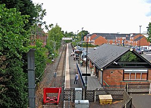
Redditch railway station
Railway station in Worcestershire, England
Distance: Approx. 1552 meters
Latitude and longitude: 52.306,-1.945
Redditch railway station serves the town of Redditch, North Worcestershire, England. It is the southern terminus of the Cross-City Line 14.5 miles (23 km) south of Birmingham New Street. The station, and all trains serving it, are operated by West Midlands Trains.

Palace Theatre, Redditch
Grade II listed theatre in Redditch in Worcestershire, England
Distance: Approx. 1536 meters
Latitude and longitude: 52.3055,-1.9379
The Palace Theatre is a Grade II listed theatre in Redditch in Worcestershire, England. It opened in 1913 and has been primarily used as a theatre, but also as a cinema, rollerskating rink and bingo hall.
Crabbs Cross
Human settlement in England
Distance: Approx. 1147 meters
Latitude and longitude: 52.281903,-1.940889
Crabbs Cross is a district of Redditch in Worcestershire, England. Crabbs Cross gets its name from the crossroads, known nowadays as the 'Star and Garter Island'. Historically, Crabbs Cross was the junction of Crabbs Cross Lane, with Evesham Road (A441) and the Slough.
Hunt End
Human settlement in England
Distance: Approx. 1767 meters
Latitude and longitude: 52.276541,-1.94841
Hunt End is a district of Redditch in Worcestershire, England. Saint Augustine's Catholic High School is in Hunt End, it is the only Catholic high school in the town. A number of businesses operate in Hunt End Industrial Estate.
Districts of Redditch
Human settlement in England
Distance: Approx. 1622 meters
Latitude and longitude: 52.28,-1.93
Redditch is a town and local government district in Worcestershire, England. The town is divided into separate districts. All street-name signs in Redditch have the street name in white lettering on a blue background and the district name in black lettering on a white background at the bottom of the sign.
Holmwood, Redditch
Country house in Worcestershire, England
Distance: Approx. 1311 meters
Latitude and longitude: 52.30277778,-1.95138889
Holmwood House in Redditch, Worcestershire, is a country house built for Canon Horace Newton of Glencripesdale Estate and Barrells Hall in 1893 by the famed Victorian architect Temple Lushington Moore, who was a vague relative of the Newton family. Rev Canon Newton was brother of Goodwin Newton of Barrells Hall, where Canon Newton also grew up.

Kingfisher Shopping Centre
Shopping mall in Redditch, England
Distance: Approx. 1507 meters
Latitude and longitude: 52.30553,-1.940455
Kingfisher Shopping Centre is a shopping centre in Redditch, England. It contains 150 stores, with a range of large and smaller units, including anchor tenants Next and Primark. The home, leisure and garden retailer The Range opened in July 2017, taking the former BHS unit.

Our Lady of Mount Carmel Church, Redditch
Church in Redditch, United Kingdom
Distance: Approx. 1677 meters
Latitude and longitude: 52.3054,-1.9317
Our Lady of Mount Carmel Church is a Roman Catholic parish church in Redditch, Worcestershire, England. It was built from 1833 to 1834 and designed by Thomas Rickman in the Gothic Revival style. It is located between Beoley Road West and Holloway Lane in the town centre.

Redditch Library
Library in the United Kingdom
Distance: Approx. 1601 meters
Latitude and longitude: 52.30636,-1.94017
Redditch Library is a library in the centre of Redditch, United Kingdom. Constructed for £550,000 (£3.3 million adjusted for inflation) and opened on 24 January 1976, it is the town's main public library, having been purpose-built to replace the former building on Church Green. It is the second-largest library in Worcestershire and attracts up to 12,500 visitors a month.
Redditch Town Hall
Municipal building in Redditch, Worcestershire, England
Distance: Approx. 1482 meters
Latitude and longitude: 52.3051,-1.9386
Redditch Town Hall is a municipal building in Walter Stranz Square in Redditch, a town in Worcestershire, in England. It is the headquarters of Redditch Borough Council.
Weather in this IP's area
scattered clouds
11 Celsius
11 Celsius
10 Celsius
14 Celsius
1014 hPa
98 %
1014 hPa
996 hPa
10000 meters
1.79 m/s
4.02 m/s
180 degree
39 %
07:38:33
18:06:50