Country:
 Great Britain
Region:
City:
Latitude and Longitude:
Time Zone:
Postal Code:
IP information under different IP Channel
ip-api
Country
Region
City
ASN
Time Zone
ISP
Blacklist
Proxy
Latitude
Longitude
Postal
Route
IPinfo
Country
Region
City
ASN
Time Zone
ISP
Blacklist
Proxy
Latitude
Longitude
Postal
Route
MaxMind
Country
Region
City
ASN
Time Zone
ISP
Blacklist
Proxy
Latitude
Longitude
Postal
Route
Luminati
Country
 NL
NLASN
Time Zone
Europe/Amsterdam
ISP
ATGS-MMD-AS
Latitude
Longitude
Postal
db-ip
Country
Region
City
ASN
Time Zone
ISP
Blacklist
Proxy
Latitude
Longitude
Postal
Route
ipdata
Country
Region
City
ASN
Time Zone
ISP
Blacklist
Proxy
Latitude
Longitude
Postal
Route
Popular places and events near this IP address

River Alne
River in Worcestershire and Warwickshire, England
Distance: Approx. 2060 meters
Latitude and longitude: 52.32777778,-1.86472222
The River Alne is a tributary of the Arrow and has its headwaters to the north of Wootton Wawen.

Forge Mill Needle Museum
Industry museum in Redditch, England
Distance: Approx. 2969 meters
Latitude and longitude: 52.315028,-1.934262
The Forge Mill Needle Museum in Redditch, Worcestershire, is a historic museum depicting Redditch's Industrial Heritage. Opened in 1983 by Queen Elizabeth II, it records how in Victorian times, Redditch was the international centre of the needle and fishing tackle industry and once produced 90% of the world's needles. Models and recreated scenes provide a vivid illustration of how needles were once made, and the museum organises exhibitions, demonstration, and workshops on how needles were used in the textile industry.

Bordesley Abbey
Cistercian abbey near Redditch, Worcestershire, England
Distance: Approx. 2925 meters
Latitude and longitude: 52.31666667,-1.93388889
Bordesley Abbey was a 12th-century Cistercian abbey near the town of Redditch, in Worcestershire, England. The abbey's foundation was an act of Waleran de Beaumont, Count of Meulan, who gave the monks of Garendon Abbey in Leicestershire some more land. However, Empress Matilda laid claim to the patronage of Bordesley once Waleran surrendered to her in about 1141, thus making Bordesley a royal house.

Beoley
Village in Bromsgrove District of Worcestershire
Distance: Approx. 1183 meters
Latitude and longitude: 52.324,-1.906
Beoley is a small village and larger civil parish north of Redditch in the Bromsgrove District of Worcestershire. It adjoins Warwickshire to the east. The 2021 census gave a parish population of 984, mostly at Holt End.

Arrow Valley Country Park
Country park in Redditch, Worcestershire, United Kingdom
Distance: Approx. 1869 meters
Latitude and longitude: 52.306878,-1.910677
Arrow Valley Country Park (also known as Arrow Valley Park) is a country park on the River Arrow, at Redditch, Worcestershire, England. Built by Redditch Development Corporation in the 1970s. It has 900 acres (3.6 km2) of public open space and incorporates the 27 acres (11 ha) Arrow Valley Lake, popular for dinghy sailing, fishing and birdwatching.

Holt End, Worcestershire
Human settlement in England
Distance: Approx. 583 meters
Latitude and longitude: 52.323826,-1.891537
Holt End is a village in the civil parish of Beoley in Worcestershire, England. It is the main centre of population in the parish and is frequently referred to as Beoley. The village of Holt End has a pub and a primary school.
RSA Academy Arrow Vale
Academy in Redditch, Worcestershire, England
Distance: Approx. 2434 meters
Latitude and longitude: 52.29709,-1.89743
RSA Academy Arrow Vale (formerly Arrow Vale High School) is a co-educational upper school and sixth form with academy status located in Redditch, Worcestershire, England. The school is sponsored by the Royal Society for the encouragement of Arts, Manufactures & Commerce opening as an RSA Academy in September 2012. The school is a member of the RSA Family of Academies.
Trinity High School and Sixth Form Centre
Academy in Redditch, Worcestershire
Distance: Approx. 3227 meters
Latitude and longitude: 52.308881,-1.935698
Trinity High School and Sixth Form Centre is a 13-18 co-educational academy school located in central Redditch, Worcestershire, England.
Ipsley Court
Distance: Approx. 2545 meters
Latitude and longitude: 52.2975,-1.9054
Ipsley Court was a 16th-century country house, much altered in the 18th and 20th centuries, situated at Ipsley, once Warwickshire, now since 1931, Worcestershire. It currently comprises two disconnected wings (known as Ipsley Court, and Ipsley Barn), both Grade II listed buildings which are in commercial use. The Manor of Ipsley was held by the Huband family from Norman times.
Gorcott Hill
Human settlement in England
Distance: Approx. 1648 meters
Latitude and longitude: 52.31458,-1.86771
Gorcott Hill is a small hamlet in the civil parish of Tanworth-in-Arden, in the Stratford-on-Avon district, in the county of Warwickshire, England. It is near the villages of Mappleborough Green & Studley, which are both in Warwickshire. Gorcott Hill is also near the large Worcestershire town of Redditch.
Mappleborough Green
Human settlement in England
Distance: Approx. 3271 meters
Latitude and longitude: 52.29,-1.88
Mappleborough Green is a small village and civil parish in Warwickshire, in the non-metropolitan district of Stratford-on-Avon. The village has a population of 540 and the civil parish 857. Mappleborough Green lies on the extreme western edge of Warwickshire adjacent to Redditch and thus forming part of the county border with Worcestershire, and adjoins the parishes of Studley, Tanworth-in-Arden, Beoley, Morton Bagot and Oldberrow.

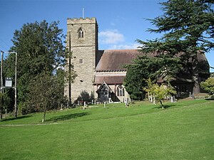
Our Lady of Mount Carmel Church, Redditch
Church in Redditch, United Kingdom
Distance: Approx. 3134 meters
Latitude and longitude: 52.3054,-1.9317
Our Lady of Mount Carmel Church is a Roman Catholic parish church in Redditch, Worcestershire, England. It was built from 1833 to 1834 and designed by Thomas Rickman in the Gothic Revival style. It is located between Beoley Road West and Holloway Lane in the town centre.
Weather in this IP's area
broken clouds
14 Celsius
14 Celsius
13 Celsius
15 Celsius
1013 hPa
84 %
1013 hPa
1001 hPa
10000 meters
3.6 m/s
200 degree
75 %
07:38:23
18:06:35