Country:
Region:
City:
Latitude and Longitude:
Time Zone:
Postal Code:
IP information under different IP Channel
ip-api
Country
Region
City
ASN
Time Zone
ISP
Blacklist
Proxy
Latitude
Longitude
Postal
Route
Luminati
Country
ASN
Time Zone
Europe/Moscow
ISP
CrimeaCom South LLC
Latitude
Longitude
Postal
IPinfo
Country
Region
City
ASN
Time Zone
ISP
Blacklist
Proxy
Latitude
Longitude
Postal
Route
db-ip
Country
Region
City
ASN
Time Zone
ISP
Blacklist
Proxy
Latitude
Longitude
Postal
Route
ipdata
Country
Region
City
ASN
Time Zone
ISP
Blacklist
Proxy
Latitude
Longitude
Postal
Route
Popular places and events near this IP address

Simferopol
Second-largest city on the Crimean Peninsula
Distance: Approx. 22 meters
Latitude and longitude: 44.95194444,34.10222222
Simferopol (), also known as Aqmescit, is the second-largest city on the Crimean Peninsula. The city, along with the rest of Crimea, is internationally recognised as part of Ukraine, controlled by Russia, and is considered the capital of the Autonomous Republic of Crimea. Since 2014 it has been under the de facto control of Russia, which annexed Crimea that year and regards Simferopol as the capital of the Republic of Crimea.

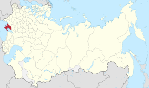
Taurida Governorate
1802–1918 unit of Russia
Distance: Approx. 467 meters
Latitude and longitude: 44.9481,34.1042
Taurida Governorate was an administrative-territorial unit (guberniya) of the Russian Empire. It included the territory of the Crimean Peninsula and the mainland between the lower Dnieper River with the coasts of the Black Sea and Sea of Azov. It formed after the Taurida Oblast was abolished in 1802 during Paul I's administrative reform of the territories of the former Crimean Khanate, which were annexed by Russia from the Ottoman Empire in 1783.

State Council of Crimea
Regional parliament of the Republic of Crimea
Distance: Approx. 432 meters
Latitude and longitude: 44.95166667,34.09694444
The State Council of Crimea is the parliament of the Russia-administered Republic of Crimea. It claims to be a continuation of the 'Supreme Council of Crimea' following a vote by the Ukrainian parliament to dissolve the Supreme Council of Crimea. The Parliament is housed in the Parliament building in the centre of Simferopol.

Simferopol Raion
Raion in Crimea, Disputed:
Distance: Approx. 27 meters
Latitude and longitude: 44.9519,34.1022
Simferopol Raion (Ukrainian: Сімферопольський район, Russian: Симферопольский район, Crimean Tatar: Aqmescit rayonı) is one of the 25 regions of the Crimean peninsula, administered by Russia, but considered by many countries as part of Ukraine. The administrative center of the raion is the city of Simferopol which is incorporated as a town of republican significance and is not a part of the district. The Simferopol Raion is situated in the central part of the peninsula.

Verkhovna Rada of Crimea
1991–2014 parliament of Crimea
Distance: Approx. 432 meters
Latitude and longitude: 44.95166667,34.09694444
Verkhovna Rada of Crimea or the Supreme Council of Crimea, officially the Supreme Council of the Autonomous Republic of Crimea, was the Ukrainian legislative body for the Autonomous Republic of Crimea before the annexation of Crimea by Russia in 2014. The last election of parliament took place on 31 October 2010 (see 2010 Crimean parliamentary election) and was won by the Party of Regions and the Communist Party of Ukraine. On 27 February 2014, unidentified armed men took over the parliament and hoist the flag of Russia over it.

The Shot in the Back
Statue in Simferopol, Crimea
Distance: Approx. 68 meters
Latitude and longitude: 44.9525,34.10305556
The Shot in the Back (Ukrainian: По́стріл у спи́ну, Russian: Вы́стрел в спи́ну) is monument in Simferopol, Crimea, funded by Crimean residents and the Communist Party of Ukraine (KPU) to commemorate Ukrainian Soviet citizens and Red Army soldiers who were killed by the Ukrainian Insurgent Army (UPA) members during and after World War II. Standing 3.5 meters high, the monument was installed on Sovetskaya square. It was unveiled on 14 September 2007.

Kebir Mosque, Simferopol
Sunni mosque in Simferopol, Crimea
Distance: Approx. 506 meters
Latitude and longitude: 44.94888889,34.10694444
The Kebir Mosque (Russian: Кебир-Джами, Ukrainian: Кебір-Джамі, Crimean Tatar: Kebir Cami, Turkish: Kebir Camii, all transliterated as Kebir-Jami) is located in Simferopol, Crimea. The Kebir Mosque is a prominent architectural monument in Simferopol and the oldest building in the city.

Building of the Supreme Council of Crimea
Distance: Approx. 452 meters
Latitude and longitude: 44.951669,34.096692
The building of the Supreme Council of Crimea (Russian: Здание парламента Крыма; Ukrainian: Будівля Верховної Ради Автономної Республіки Крим) is an administrative building in Simferopol, Crimea. It housed the Supreme Council of the Autonomous Republic of Crimea and currently hosts the State Council of Republic of Crimea following the annexation of Crimea by the Russian Federation in 2014.

Capture of the Crimean Parliament
Part of the Russo-Ukrainian War
Distance: Approx. 452 meters
Latitude and longitude: 44.951669,34.096692
On 27 February 2014, the Crimean Verkhovna Rada of Ukraine was taken over by unmarked Russian soldiers. It was among the events that triggered the Russo-Ukrainian War and laid the foundation for Crimea's annexation three weeks later. The Prosecutor's Office of Ukraine's Autonomous Republic of Crimea described the incident as a terrorist attack.

Kyivskyi District, Simferopol
Urban district in Simferopol in Crimea, Disputed:
Distance: Approx. 301 meters
Latitude and longitude: 44.95,34.1
Kyivskyi District (Russian: Киевский район; Ukrainian: Київський район) is an administrative raion (district) of the city of Simferopol. Population: 154,595 (2014 Census).

Zaliznychnyi District, Simferopol
Urban district in Simferopol in Crimea, Disputed:
Distance: Approx. 320 meters
Latitude and longitude: 44.95055556,34.10583333
Zaliznychnyi District (Ukrainian: Залізничний район; Russian: Железнодорожный район) is an administrative raion (district) of the city of Simferopol. Population: 78,022 (2014 Census).
Republic of Crimea (1992–1995)
Autonomous region of Ukraine
Distance: Approx. 2 meters
Latitude and longitude: 44.95211667,34.1024
The Republic of Crimea was the interim name of a polity on the Crimean peninsula from the dissolution of the Crimean Autonomous Soviet Socialist Republic in 1992 to the abolition of the Crimean Constitution by the Ukrainian Parliament in 1995. This period was one of conflict with the Ukrainian government over the levels of autonomy that Crimea enjoyed in relation to Ukraine, and links between Crimea and the Russian Federation.
Weather in this IP's area
broken clouds
6 Celsius
3 Celsius
6 Celsius
6 Celsius
1027 hPa
82 %
1027 hPa
997 hPa
10000 meters
3.65 m/s
6.24 m/s
83 degree
57 %
07:34:36
17:20:35