195.26.74.6 - IP Lookup: Free IP Address Lookup, Postal Code Lookup, IP Location Lookup, IP ASN, Public IP
Country:
Region:
City:
Location:
Time Zone:
Postal Code:
IP information under different IP Channel
ip-api
Country
Region
City
ASN
Time Zone
ISP
Blacklist
Proxy
Latitude
Longitude
Postal
Route
Luminati
Country
ASN
Time Zone
Europe/Warsaw
ISP
Vectra S.A.
Latitude
Longitude
Postal
IPinfo
Country
Region
City
ASN
Time Zone
ISP
Blacklist
Proxy
Latitude
Longitude
Postal
Route
IP2Location
195.26.74.6Country
Region
lodzkie
City
sieradz
Time Zone
Europe/Warsaw
ISP
Language
User-Agent
Latitude
Longitude
Postal
db-ip
Country
Region
City
ASN
Time Zone
ISP
Blacklist
Proxy
Latitude
Longitude
Postal
Route
ipdata
Country
Region
City
ASN
Time Zone
ISP
Blacklist
Proxy
Latitude
Longitude
Postal
Route
Popular places and events near this IP address

Sieradz Voivodeship
Administrative division and local government in Poland between 1975–1998
Distance: Approx. 328 meters
Latitude and longitude: 51.592855,18.730431
Sieradz Voivodeship (Polish: województwo sieradzkie) was a unit of administrative division and local government in Poland in the years 1975–1998, superseded by Łódź Voivodeship. A Voivodeship is an area administered by a voivode (Governor), and the Sieradz Voivodeship is the area with the capital city of Sieradz. Sieradz is a significant city of Poland as it is one of the oldest cities of the country, tracing back roughly to the 6th century.

Sieradz
Town in Łódź, Poland
Distance: Approx. 1447 meters
Latitude and longitude: 51.6,18.75
Sieradz [ˈɕɛrat͡s] (Latin: Siradia, Yiddish: שעראַדז, שערעדז, שעריץ, German: 1941-45 Schieratz) is a city on the Warta river in central Poland with 40,891 inhabitants (2021). It is the seat of the Sieradz County, situated in the Łódź Voivodeship. Sieradz is a capital of the historical Sieradz Land.
Nauczycielskie Kolegium Języków Obcych in Sieradz
Distance: Approx. 2176 meters
Latitude and longitude: 51.581196,18.709287

Sieradz County
County in Łódź Voivodeship, Poland
Distance: Approx. 1447 meters
Latitude and longitude: 51.6,18.75
Sieradz County (Polish: powiat sieradzki) is a unit of territorial administration and local government (powiat) in Łódź Voivodeship, central Poland. It came into being on January 1, 1999, as a result of the Polish local government reforms passed in 1998. Its administrative seat and largest town is Sieradz, which lies 54 kilometres (34 mi) west of the regional capital Łódź.

Sieradz Voivodeship (1339–1793)
Distance: Approx. 328 meters
Latitude and longitude: 51.592855,18.730431
Sieradz Voivodeship (Polish: Województwo sieradzkie, Latin: Palatinatus Siradiensis) was a unit of administrative division and local government in the Kingdom of Poland and the Polish–Lithuanian Commonwealth, from 1339 to the second partition of Poland in 1793. It was a part of the Greater Poland Province. The seat of the voivode was in Sieradz, while local sejmiks took place in Szadek.
Gmina Sieradz
Gmina in Łódź Voivodeship, Poland
Distance: Approx. 1447 meters
Latitude and longitude: 51.6,18.75
Gmina Sieradz is a rural gmina (administrative district) in Sieradz County, Łódź Voivodeship, in central Poland. Its seat is the town of Sieradz, although the town is not part of the territory of the gmina. The gmina covers an area of 181.63 square kilometres (70.1 sq mi), and as of 2006 its total population is 9,788.
Charłupia Mała
Village in Łódź Voivodeship, Poland
Distance: Approx. 3987 meters
Latitude and longitude: 51.61666667,18.68333333
Charłupia Mała [xarˈwupja ˈmawa] is a village in the administrative district of Gmina Sieradz, within Sieradz County, Łódź Voivodeship, in central Poland. It lies approximately 5 kilometres (3 mi) west of Sieradz and 58 km (36 mi) west of the regional capital Łódź.
Dzigorzew
Village in Łódź Voivodeship, Poland
Distance: Approx. 2504 meters
Latitude and longitude: 51.61666667,18.71666667
Dzigorzew [d͡ʑiˈɡɔʐɛf] is a village in the administrative district of Gmina Sieradz, within Sieradz County, Łódź Voivodeship, in central Poland. It lies approximately 3 kilometres (2 mi) north-west of Sieradz and 55 km (34 mi) west of the regional capital Łódź.
Kłocko
Village in Łódź Voivodeship, Poland
Distance: Approx. 4855 meters
Latitude and longitude: 51.57,18.67361111
Kłocko [ˈkwɔt͡skɔ] is a village in the administrative district of Gmina Sieradz, within Sieradz County, Łódź Voivodeship, in central Poland. It lies approximately 7 kilometres (4 mi) south-west of Sieradz and 60 km (37 mi) south-west of the regional capital Łódź.
Mnichów, Łódź Voivodeship
Village in Łódź Voivodeship, Poland
Distance: Approx. 3259 meters
Latitude and longitude: 51.62472222,18.7375
Mnichów [ˈmnixuf] is a village in the administrative district of Gmina Sieradz, within Sieradz County, Łódź Voivodeship, in central Poland. It lies approximately 3 kilometres (2 mi) north of Sieradz and 54 km (34 mi) west of the regional capital Łódź.
Sucha, Łódź Voivodeship
Village in Łódź Voivodeship, Poland
Distance: Approx. 4671 meters
Latitude and longitude: 51.63333333,18.7
Sucha [ˈsuxa] is a village in the administrative district of Gmina Sieradz, within Sieradz County, Łódź Voivodeship, in central Poland. It lies approximately 6 kilometres (4 mi) north-west of Sieradz and 56 km (35 mi) west of the regional capital Łódź.
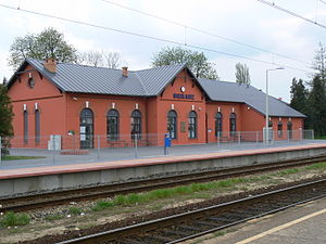
Sieradz railway station
Railway station in Sieradz, Poland
Distance: Approx. 1081 meters
Latitude and longitude: 51.59805556,18.715
Sieradz is a railway station located in the Polish town of Sieradz, in Łódź Voivodeship. It is classified by PKP as a regional station. The station serves mainly regional services between Łódź and Poznań, as well as PKP Intercity trains running between Warsaw and Wrocław.
Weather in this IP's area
scattered clouds
-2 Celsius
-9 Celsius
-2 Celsius
-2 Celsius
1016 hPa
82 %
1016 hPa
999 hPa
7249 meters
7.87 m/s
12.33 m/s
293 degree
46 %
