Country:
 Denmark
Region:
City:
Latitude and Longitude:
Time Zone:
Postal Code:
IP information under different IP Channel
ip-api
Country
Region
City
ASN
Time Zone
ISP
Blacklist
Proxy
Latitude
Longitude
Postal
Route
IPinfo
Country
Region
City
ASN
Time Zone
ISP
Blacklist
Proxy
Latitude
Longitude
Postal
Route
MaxMind
Country
Region
City
ASN
Time Zone
ISP
Blacklist
Proxy
Latitude
Longitude
Postal
Route
Luminati
Country
DKASN
Time Zone
Europe/Copenhagen
ISP
Aarhus Business College
Latitude
Longitude
Postal
db-ip
Country
Region
City
ASN
Time Zone
ISP
Blacklist
Proxy
Latitude
Longitude
Postal
Route
ipdata
Country
Region
City
ASN
Time Zone
ISP
Blacklist
Proxy
Latitude
Longitude
Postal
Route
Popular places and events near this IP address

Aarhus
City in Central Denmark Region, Denmark
Distance: Approx. 291 meters
Latitude and longitude: 56.1572,10.2107
Aarhus (, US also , Danish: [ˈɒːˌhuˀs] ; officially spelled Århus from 1948 until 1 January 2011) is the second-largest city in Denmark and the seat of Aarhus Municipality. It is located on the eastern shore of Jutland in the Kattegat sea and approximately 187 kilometres (116 mi) northwest of Copenhagen. Dating back to the late 8th century, Aarhus was founded as a harbour settlement at the mouth of the Aarhus River and quickly became a trade hub.
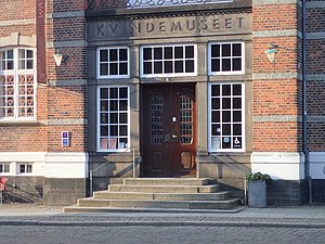
Gender Museum Denmark
Museum in Aarhus, Denmark
Distance: Approx. 245 meters
Latitude and longitude: 56.15716667,10.21144444
KØN - Gender Museum Denmark, formerly Kvindemuseet (Women's Museum), is a history museum in Aarhus, Denmark focused on the cultural history of gender and sexuality in Denmark. KØN was originally founded in 1982 as a women's history museum, and is housed in the former Aarhus City Hall, built in 1857. In 2016, the museum's thematic focus was expanded to encompass issues of gender and sexuality in the broadest sense, and as a result of that, the museum's name was changed to KØN (Gender in English) in 2021.

Aarhus Custom House
Distance: Approx. 191 meters
Latitude and longitude: 56.1555,10.2131
The Aarhus Custom House (Toldkammeret) is located on the harbour front in Aarhus, Denmark. Completed in 1898, it is said to be Hack Kampmann's finest work. Kampmann also designed other buildings in the city including Marselisborg Palace and Aarhus Teater.

Aarhus Katedralskole
Distance: Approx. 189 meters
Latitude and longitude: 56.157,10.2123
Aarhus Katedralskole is a cathedral school, an institution of secondary education, a Danish Gymnasium and a listed building in Aarhus, Denmark. The school is situated in the neighborhood Midtbyen, in the Latin Quarter, bounded by the streets Mejlgade, Kystvejen and Skolegyde. Aarhus Katedralskole offers the 3 year Matriculation examination (STX) programme with elective subjects in the natural sciences, social sciences and arts.

Aarhus School of Marine and Technical Engineering
Distance: Approx. 222 meters
Latitude and longitude: 56.158694,10.215436
Aarhus School of Marine and Technical Engineering (Danish: Aarhus Maskinmesterskole or AAMS) is a school of higher education in Aarhus, Denmark. The school is a self owning institution and offers bachelor's degree in marine and technical engineering - with electives such as marine engineering and automation, energy and technology. In the summer of 2014, the school took residence in the new Navitas building at Aarhus Docklands and initiated a cooperative programme with Business Academy Aarhus, offering Academy Profession Degrees in Automotive Technology (Danish: autoteknolog) and Automation Engineering (Danish: automationsteknolog).

St. Oluf's Cemetery
Historic site in Aarhus, Denmark
Distance: Approx. 237 meters
Latitude and longitude: 56.158406,10.213002
St. Oluf Cemetery (Danish: Sankt Olufs Kirkegård) is a small public park and historic site in central Aarhus, Denmark. The park is situated by the coast in the city center of Midtbyen, in the Latin Quarter, bounded by the streets of Kystvejen and St.

Old City Hall (Aarhus)
Building in Aarhus, Denmark
Distance: Approx. 252 meters
Latitude and longitude: 56.1571,10.2113
Aarhus Old City Hall is the former city hall of Aarhus, Denmark, and a listed building. The city hall was built in 1857 and was listed in the Danish national registry of protected buildings and places by the Danish Heritage Agency on 18 March 1996. It is the second, and oldest preserved, city hall of Aarhus.

Stykgodspakhuset
Building in Aarhus, Denmark
Distance: Approx. 248 meters
Latitude and longitude: 56.1548,10.2132
Stykgodspakhuset, or Pakhus 13, is a former warehouse and a listed building in Aarhus, Denmark. The warehouse was built in 1926 and was listed in the Danish national registry of protected buildings and places by the Danish Heritage Agency on 4 April 2006. The warehouse is situated on the water front of the Port of Aarhus in the central Indre by neighbourhood next to the Custom House and has functioned as a storehouse for parcels and other small cargo since completion to the mid 20th century.

Juul's House
House in Aarhus, Denmark built in 1629
Distance: Approx. 269 meters
Latitude and longitude: 56.1582,10.2119
Juul's House is a house and a listed building in Aarhus, Denmark. The house was built in 1629 and was listed on the national Danish registry of protected buildings and places by the Danish Heritage Agency on 1 April 1984. The building is one of the oldest in the city and it is situated in the historical Latin Quarter on Mejlgade.

Skolegade
Distance: Approx. 282 meters
Latitude and longitude: 56.1554,10.2114
Skolegade (Lit.: School Street) is a street in Aarhus, Denmark which runs north to south from Mejlgade to Mindebrogade. The street is situated in the Midtbyen neighborhood. Skolegade is home to two listed buildings and runs past the Aarhus Theater.

Navitas Park
Research Center in Aarhus, Denmark
Distance: Approx. 212 meters
Latitude and longitude: 56.1586,10.2155
Navitas (or Navitas Park) is a building in the city of Aarhus, Denmark, located in the Docklands neighborhood in the Midtbyen district. Navitas is owned by the research park INCUBA Science Park, the Aarhus University School of Engineering and the Aarhus School of Marine and Technical Engineering. The three institutions together operate a consortium that maintains the facilities and together they inhabit the building.
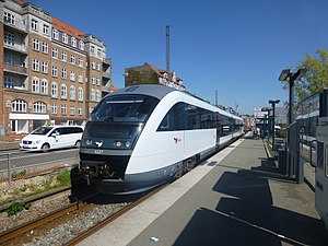
Skolebakken railway halt
Railway halt in Aarhus, Denmark
Distance: Approx. 147 meters
Latitude and longitude: 56.15682222,10.21294444
Skolebakken railway halt is a railway halt serving the central part of the city of Aarhus in Jutland, Denmark. The station is located on the Grenaa Line between Aarhus and Grenaa. In 2016, the station was temporarily closed along with the Grenaa Line while it's being reconstructed to form part of the Aarhus light rail system.
Weather in this IP's area
broken clouds
8 Celsius
6 Celsius
8 Celsius
8 Celsius
1013 hPa
91 %
1013 hPa
1013 hPa
10000 meters
4.65 m/s
9.83 m/s
243 degree
60 %
07:42:47
18:28:29