195.252.228.96 - IP Lookup: Free IP Address Lookup, Postal Code Lookup, IP Location Lookup, IP ASN, Public IP
Country:
Region:
City:
Location:
Time Zone:
Postal Code:
IP information under different IP Channel
ip-api
Country
Region
City
ASN
Time Zone
ISP
Blacklist
Proxy
Latitude
Longitude
Postal
Route
Luminati
Country
Region
ia
City
hampton
ASN
Time Zone
America/Chicago
ISP
AS-CMN
Latitude
Longitude
Postal
IPinfo
Country
Region
City
ASN
Time Zone
ISP
Blacklist
Proxy
Latitude
Longitude
Postal
Route
IP2Location
195.252.228.96Country
Region
iowa
City
hampton
Time Zone
America/Chicago
ISP
Language
User-Agent
Latitude
Longitude
Postal
db-ip
Country
Region
City
ASN
Time Zone
ISP
Blacklist
Proxy
Latitude
Longitude
Postal
Route
ipdata
Country
Region
City
ASN
Time Zone
ISP
Blacklist
Proxy
Latitude
Longitude
Postal
Route
Popular places and events near this IP address

Franklin County, Iowa
County in Iowa, United States
Distance: Approx. 5463 meters
Latitude and longitude: 42.73083333,-93.2675
Franklin County is a county located in the U.S. state of Iowa. As of the 2020 census, the population was 10,019. The county seat is Hampton.
Hampton, Iowa
Town in Iowa, United States
Distance: Approx. 458 meters
Latitude and longitude: 42.74305556,-93.20777778
Hampton is a town and county seat of Franklin County, Iowa, United States. The population was 4,337 at the time of the 2020 census.
Franklin County G. A. R. Soldiers' Memorial Hall (Iowa)
United States historic place
Distance: Approx. 381 meters
Latitude and longitude: 42.74202778,-93.20705556
The Franklin County G. A. R. Soldiers' Memorial Hall, also known simply as the Soldiers' Memorial Hall, is a historic building located in Hampton, Iowa, United States. The octagonal-style structure was designed and built in 1890 by Edward Carl Keifer. It was the meeting place of the J.W. McKenzie Post No.

Franklin County Courthouse (Iowa)
United States historic place
Distance: Approx. 534 meters
Latitude and longitude: 42.74138889,-93.20888889
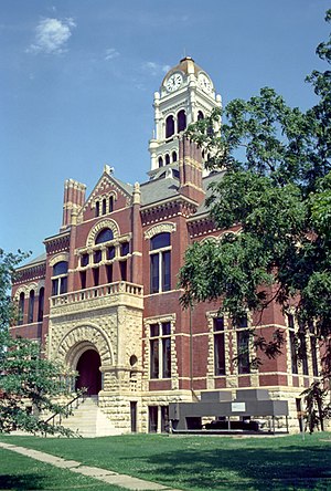
The Franklin County Courthouse in Hampton, Iowa, United States was built in 1891. It was individually listed on the National Register of Historic Places in 1976 as a part of the County Courthouses in Iowa Thematic Resource. In 2003 it was included as a contributing property in the Hampton Double Square Historic District.
Hampton Double Square Historic District
Historic district in Iowa, United States
Distance: Approx. 440 meters
Latitude and longitude: 42.74194444,-93.20777778
The Hampton Double Square Historic District is a historic district located in Hampton, Iowa, United States. It has been listed on the National Register of Historic Places since 2003. At the time of its nomination it contained 43 resources, which included 28 contributing buildings, two contributing sites, 10 non-contributing buildings, one non-contributing site, one non-contributing structures, and one non-contributing object.
Dr. O.B. Harriman House
Historic house in Iowa, United States
Distance: Approx. 1484 meters
Latitude and longitude: 42.74194444,-93.22055556
The Dr. O.B. Harriman House, also known as the Harriman Nielsen Historic Farm, is an historic structure located in Hampton, Iowa, United States. The Italianate style house was built in 1881.

Mott Township, Franklin County, Iowa
Township in Iowa, United States
Distance: Approx. 4056 meters
Latitude and longitude: 42.77833333,-93.2025
Mott Township is one of sixteen townships in Franklin County, Iowa, United States. As of the 2010 census, its population was 498 and it contained 237 housing units.

Reeve Township, Franklin County, Iowa
Township in Iowa, United States
Distance: Approx. 6149 meters
Latitude and longitude: 42.68666667,-93.2025
Reeve Township is one of sixteen townships in Franklin County, Iowa, United States. As of the 2010 census, its population was 262 and it contained 135 housing units.
H.E. Boehmler House
Historic house in Iowa, United States
Distance: Approx. 260 meters
Latitude and longitude: 42.74055556,-93.205
The H.E. Boehmler House is a historic dwelling located in Hampton, Iowa, United States. Boehmler was a pharmacist, and his wife conducted art classes in their home. This house was built in 1915, and designed in the Prairie School style by J.H. Jeffers and Einar Broaten.
Franklin County Sheriff's Residence and Jail
Historic government buildings in Iowa, United States
Distance: Approx. 326 meters
Latitude and longitude: 42.74194444,-93.20638889
The Franklin County Sheriff's Residence and Jail is a historic building located in Hampton, Iowa, United States. The combination sheriff's residence and jail was the most common type of detention facility built by Iowa counties from the 1840s to around 1950. In this facility in Hampton the sheriff's residence was the two-story Italianate style structure closest to the street.
Beeds Lake State Park
State park in Franklin County, Iowa
Distance: Approx. 5299 meters
Latitude and longitude: 42.77027778,-93.25444444
Beeds Lake State Park is located northwest of Hampton, Iowa, United States. It was listed has a historic district on the National Register of Historic Places as Beeds Lake State Park, Civilian Conservation Corps Area in 1990. At the time of its nomination it contained 21 resources, which included one contributing building, 15 contributing structures, and five non-contributing structures.
Hampton–Dumont Community School District
Public school district in Hampton, Iowa, United States
Distance: Approx. 1175 meters
Latitude and longitude: 42.75199,-93.198193
Hampton–Dumont Community School District is a rural public school district headquartered in Hampton, Iowa. It is in Franklin and Butler counties, serving Hampton, Dumont, Hansell, and Aredale. As of 2020, the district had 1,275 students.
Weather in this IP's area
fog
-2 Celsius
-2 Celsius
-2 Celsius
0 Celsius
1009 hPa
100 %
1009 hPa
966 hPa
402 meters
100 %


