Country:
Region:
City:
Latitude and Longitude:
Time Zone:
Postal Code:
IP information under different IP Channel
ip-api
Country
Region
City
ASN
Time Zone
ISP
Blacklist
Proxy
Latitude
Longitude
Postal
Route
Luminati
Country
Region
in
City
westfield
ASN
Time Zone
America/Indiana/Indianapolis
ISP
AS-CMN
Latitude
Longitude
Postal
IPinfo
Country
Region
City
ASN
Time Zone
ISP
Blacklist
Proxy
Latitude
Longitude
Postal
Route
db-ip
Country
Region
City
ASN
Time Zone
ISP
Blacklist
Proxy
Latitude
Longitude
Postal
Route
ipdata
Country
Region
City
ASN
Time Zone
ISP
Blacklist
Proxy
Latitude
Longitude
Postal
Route
Popular places and events near this IP address

Westfield, Indiana
City in Indiana, United States
Distance: Approx. 2542 meters
Latitude and longitude: 40.03222222,-86.15305556
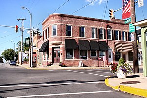
Westfield is a city in Hamilton County, Indiana, United States. As of the 2010 census the population was 30,068, and in 2023 the population was 58,410. Westfield is in the Indianapolis metropolitan area.
Westfield High School (Westfield, Indiana)
Public school in Westfield, Indiana, United States
Distance: Approx. 1158 meters
Latitude and longitude: 40.05166667,-86.13
Westfield High School is a public high school located in Westfield, Indiana, north of Indianapolis.
St. Theodore Guerin High School
Private, coeducational school in Noblesville, Indiana, United States
Distance: Approx. 6856 meters
Latitude and longitude: 40.01027778,-86.08638889
St. Theodore Guerin High School or simply Guerin Catholic High School is a private Roman Catholic college-preparatory high school located in Noblesville, Indiana, a northern Indianapolis suburb. The school's mascot is the Golden Eagle and school colors are purple and gold.

Washington Township, Hamilton County, Indiana
Township in Indiana, United States
Distance: Approx. 2535 meters
Latitude and longitude: 40.04944444,-86.1725
Westfield Washington Township is one of nine townships in Hamilton County, Indiana, United States. As of the 2010 census, its population was 32,884 and it contained 12,477 housing units. In 2007, the township had 29,361 residents.
Hortonville, Indiana
Unincorporated community and Census-designated place in Indiana, United States
Distance: Approx. 3971 meters
Latitude and longitude: 40.08777778,-86.1575
Hortonville is an unincorporated community in Washington Township, Hamilton County, Indiana, United States.

Jolietville, Indiana
Town in Indiana, United States
Distance: Approx. 7598 meters
Latitude and longitude: 40.04194444,-86.23111111
Jolietville is a neighborhood of Westfield, Indiana, in Washington Township, Hamilton County, Indiana. It was formerly an unincorporated community, but was annexed by Westfield in the late 2000s or early 2010s.
Lamong, Indiana
Unincorporated community in Indiana, United States
Distance: Approx. 6217 meters
Latitude and longitude: 40.08555556,-86.20333333
Lamong is an unincorporated community in Washington Township, Hamilton County, Indiana.

Eagletown, Indiana
Unincorporated community in Indiana, United States
Distance: Approx. 4477 meters
Latitude and longitude: 40.04222222,-86.19361111
Eagletown is an unincorporated community in Washington Township, Hamilton County, Indiana. Eagletown was laid out in 1848. It took its name from the Little Eagle Creek.
Clay Terrace
Shopping mall in Carmel, Indiana
Distance: Approx. 6439 meters
Latitude and longitude: 39.997,-86.129
Clay Terrace is a community lifestyle center in Carmel, Indiana. Opened in 2004, it is managed by Washington Prime Group.

Union Bible College and Academy
United States historic place
Distance: Approx. 2237 meters
Latitude and longitude: 40.03861111,-86.12611111
Union Bible College and Academy is a private, Christian educational institution combining a KG-12 academy and college in Westfield, Indiana. It was founded in 1861 by the Religious Society of Friends (Quakers), receiving patronage from the Central Yearly Meeting and being aligned with the conservative holiness movement. It was listed on the National Register of Historic Places in 1995.
Grand Park (Indiana)
Distance: Approx. 671 meters
Latitude and longitude: 40.0580029,-86.1489468
Grand Park Sports Campus is a sports complex located in Westfield, Indiana about 30 miles north of Indianapolis, Indiana. The 400-acre (160 ha) park features 26 baseball and softball diamonds, 31 multipurpose fields for soccer, football, and lacrosse. The Grand Park Events Center is now open, featuring three full-sized indoor soccer fields, a restaurant and administrative offices.

Hinkle Creek (Indiana)
Stream in Indiana, USA
Distance: Approx. 7427 meters
Latitude and longitude: 40.09361111,-86.07333333
Hinkle Creek is a stream in Indiana which empties into Morse Reservoir. Via Cicero Creek, the outlet of Morse Reservoir, it is part of the White River watershed, and thence the Wabash, Ohio, and Mississippi rivers. Quaker settlers established Hinkle Creek Church in 1836 near the stream.
Weather in this IP's area
moderate rain
18 Celsius
18 Celsius
17 Celsius
18 Celsius
1009 hPa
93 %
1009 hPa
977 hPa
10000 meters
5.14 m/s
180 degree
100 %
07:18:53
17:37:28