Country:
 Germany
Region:
City:
Latitude and Longitude:
Time Zone:
Postal Code:
IP information under different IP Channel
ip-api
Country
Region
City
ASN
Time Zone
ISP
Blacklist
Proxy
Latitude
Longitude
Postal
Route
IPinfo
Country
Region
City
ASN
Time Zone
ISP
Blacklist
Proxy
Latitude
Longitude
Postal
Route
MaxMind
Country
Region
City
ASN
Time Zone
ISP
Blacklist
Proxy
Latitude
Longitude
Postal
Route
Luminati
Country
DEASN
Time Zone
Europe/Berlin
ISP
Hughes Network Systems GmbH
Latitude
Longitude
Postal
db-ip
Country
Region
City
ASN
Time Zone
ISP
Blacklist
Proxy
Latitude
Longitude
Postal
Route
ipdata
Country
Region
City
ASN
Time Zone
ISP
Blacklist
Proxy
Latitude
Longitude
Postal
Route
Popular places and events near this IP address

European Space Operations Centre
Main mission control centre for the European Space Agency
Distance: Approx. 4474 meters
Latitude and longitude: 49.87111111,8.62277778
The European Space Operations Centre (ESOC) serves as the main mission control centre for the European Space Agency (ESA) and is located in Darmstadt, Germany. ESOC's primary function is the operation of uncrewed spacecraft on behalf of ESA and the launch and early orbit phases (LEOP) of ESA and third-party missions. The Centre is also responsible for a range of operations-related activities within ESA and in cooperation with ESA's industry and international partners, including ground systems engineering, software development, flight dynamics and navigation, development of mission control tools and techniques and space debris studies.

EUMETSAT
European intergovernmental organisation
Distance: Approx. 4826 meters
Latitude and longitude: 49.865,8.62694444
The European Organisation for the Exploitation of Meteorological Satellites (EUMETSAT) is an intergovernmental organisation created through an international convention agreed by a current total of 30 European Member States. EUMETSAT's primary objective is to establish, maintain and exploit European systems of operational meteorological satellites. EUMETSAT is responsible for the launch and operation of the satellites and for delivering satellite data to end-users as well as contributing to the operational monitoring of climate and the detection of global climate changes.

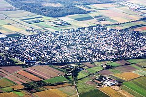
Griesheim, Hesse
Town in Hesse, Germany
Distance: Approx. 872 meters
Latitude and longitude: 49.86388889,8.56388889
Griesheim (German pronunciation: [ˈɡʁiːsˌhaɪ̯m] ) is the largest town in the Darmstadt-Dieburg district of Darmstadt in the southern state of Hesse. It has just over 28,000 inhabitants as of December 2023. Griesheim is known for being the location of the first German airfield, which was founded in 1908.

Darmstadt University of Applied Sciences
Distance: Approx. 5261 meters
Latitude and longitude: 49.86638889,8.63333333
The Darmstadt University of Applied Sciences (German: Hochschule Darmstadt), also known as h_da, is a University of Applied Sciences located in Darmstadt, Germany. h_da is part of the IT cluster Rhine-Main-Neckar, the "Silicon Valley of Germany" and ATHENE, the largest research institute for IT security in Europe.
Weiterstadt
Town in Hesse, Germany
Distance: Approx. 4266 meters
Latitude and longitude: 49.9,8.6
Weiterstadt (German pronunciation: [ˈvaɪ̯tɐˌʃtat] ) is a town in the Darmstadt-Dieburg district, in Hesse, Germany. It is situated directly northwest of Darmstadt.

Büttelborn
Municipality in Hesse, Germany
Distance: Approx. 4470 meters
Latitude and longitude: 49.9,8.51666667
Büttelborn is a municipality in Groß-Gerau district in Hesse, Germany.

Darmstadt Hauptbahnhof
Main railway station of Darmstadt, Germany
Distance: Approx. 4954 meters
Latitude and longitude: 49.8725,8.62944444
Darmstadt Hauptbahnhof is the main railway station in the German city Darmstadt. After Frankfurt Hbf and Wiesbaden Hbf, it is the third largest station in the state of Hesse with 35,000 passengers and 220 trains per day. Built in a late art nouveau style, the station was finished 1912 as one of the major works of architect Friedrich Pützer.
Braunshardt Airfield
Former German military airfield
Distance: Approx. 4502 meters
Latitude and longitude: 49.91,8.541667
Braunshardt Airfield is a former military airfield in Germany, about 2.7 miles (4.3 kilometers) east-southeast of the center of Groß-Gerau (Hesse) into Worfelden district, and approximately 275 miles (440 kilometers) southwest of Berlin.
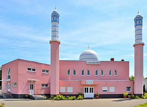
Nuur-ud-Din Mosque
Mosque in Darmstadt, Germany
Distance: Approx. 4600 meters
Latitude and longitude: 49.88530556,8.62080556
Nuur-ud-Din Mosque (English: Mosque of the Light of Religion) in Darmstadt, Germany is run by the Ahmadiyya Muslim Community. The foundation stone was laid in May 2002 and was inaugurated in August 2003 by 5th Caliph of the Messiah, Mirza Masroor Ahmad. The mosque is named after 1st Caliph of the Messiah, Hakeem Noor-ud-Din.

Center for Advanced Security Research Darmstadt
Distance: Approx. 5372 meters
Latitude and longitude: 49.8725,8.63527778
The Center for Advanced Security Research Darmstadt (CASED) was a center for IT security research and development with an interdisciplinary and cross-organizational approach. It was founded in July 2008 by TU Darmstadt, the Fraunhofer Institute for Secure Information Technology (SIT) and the Darmstadt University of Applied Sciences. CASED promoted and coordinated cooperation between the three institutions.

Dagger Complex
US Army base in Darmstadt, Hesse, Germany
Distance: Approx. 3518 meters
Latitude and longitude: 49.84378056,8.58423611
The Dagger Complex is a US military base in Darmstadt (Germany), close to Griesheim and located at the Eberstädter Weg, south of the August-Euler-Airfield. The complex is under US Army Intelligence and Security Command (INSCOM) command on behalf of the US National Security Agency (NSA) and is officially known as Subunit 1 operated by USMC G Company. After a large basement expansion at the complex in 2002 it hosted an important SIGINT processing, analysis and reporting center.

Weiterstadt prison bombing
Distance: Approx. 2522 meters
Latitude and longitude: 49.89397,8.56342
The Weiterstadt prison bombing occurred on 27 March 1993, when the Red Army Faction (RAF) Command Katharina Hammerschmidt bombed and destroyed a newly built prison in Weiterstadt, near Frankfurt am Main in Germany. It was the RAF's "last anticapitalist attack" before it dissolved. Nobody was harmed in the explosion of the empty prison.
Weather in this IP's area
few clouds
20 Celsius
20 Celsius
19 Celsius
22 Celsius
1012 hPa
83 %
1012 hPa
1001 hPa
10000 meters
2.57 m/s
160 degree
20 %
06:51:53
19:55:10