Country:
 Belgium
Region:
City:
Latitude and Longitude:
Time Zone:
Postal Code:
IP information under different IP Channel
ip-api
Country
Region
City
ASN
Time Zone
ISP
Blacklist
Proxy
Latitude
Longitude
Postal
Route
IPinfo
Country
Region
City
ASN
Time Zone
ISP
Blacklist
Proxy
Latitude
Longitude
Postal
Route
MaxMind
Country
Region
City
ASN
Time Zone
ISP
Blacklist
Proxy
Latitude
Longitude
Postal
Route
Luminati
Country
BEASN
Time Zone
Europe/Brussels
ISP
Bart Champagne
Latitude
Longitude
Postal
db-ip
Country
Region
City
ASN
Time Zone
ISP
Blacklist
Proxy
Latitude
Longitude
Postal
Route
ipdata
Country
Region
City
ASN
Time Zone
ISP
Blacklist
Proxy
Latitude
Longitude
Postal
Route
Popular places and events near this IP address

Sint-Truiden
City and municipality in Flemish Community, Belgium
Distance: Approx. 1454 meters
Latitude and longitude: 50.8,5.18333333
Sint-Truiden (Dutch pronunciation: [sɪnˈtrœydə(n)] ; French: Saint-Trond [sɛ̃ tʁɔ̃]; Limburgish: Sintruin [sɪnˈtʀœjn]) is a city and municipality located in the province of Limburg, Flemish Region, Belgium, and has over 41,500 inhabitants, which makes it one of the largest cities in Limburg. The municipality includes the former communes (now deelgemeenten) of Aalst, Brustem, Duras, Engelmanshoven, Gelinden, Gorsem, Groot-Gelmen, Halmaal, Kerkom-bij-Sint-Truiden, Melveren, Metsteren, Ordingen, Runkelen, Velm, Wilderen, and Zepperen. The city is in the centre of Belgium's fruit-producing region, Haspengouw (Hesbaye), and is renowned for its pears, apples (Jonagold), and sweet cherries.

Stayen
Football stadium in Sint-Truiden, Belgium
Distance: Approx. 699 meters
Latitude and longitude: 50.813474,5.166256
Stayen is a football stadium in Sint-Truiden, Belgium. It is the home ground of STVV. The stadium holds 14,600 after its most recent rebuild. The original stadium was built in 1927.

Château de Duras
Belgian castle
Distance: Approx. 3249 meters
Latitude and longitude: 50.835,5.152
The Château de Duras (Castle of Duras) in Duras, a half hour walk to the north of Sint-Truiden in Belgium, is built in the Classical style . This Belgian castle was built between 1787 and 1789 and is located in a beautiful area. The castle was built on the location of the original castle of the Counts of Duras, which was built in 1102.
Sint-Truiden / Brustem Airfield
Airport in Brustem , Belgium
Distance: Approx. 3025 meters
Latitude and longitude: 50.79194444,5.20166667
Sint-Truiden / Brustem Airfield (Dutch: Vliegveld Sint Truiden, ICAO: EBST) is an airfield located in Brustem, 1.5 nautical miles (2.8 km; 1.7 mi) southeast of Sint-Truiden (Limburg) and approximately 37 mi (60 km) east of Brussels. Formerly known as Sint-Truiden Air Base (Dutch: Luchtmachtbasis Sint-Truiden, French: Base Aérienne Saint-Trond) or Brustem Air Base (Dutch: Vliegbasis Brustem, French: Base aérienne de Brustem), the aerodrome was deactivated as a Belgian Air Component base in 1996.

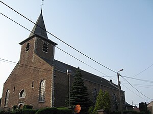
Kerkom-bij-Sint-Truiden
Village in Flemish Community, Belgium
Distance: Approx. 3949 meters
Latitude and longitude: 50.7729,5.1804
Kerkom-bij-Sint-Truiden (or simply Kerkom) is a village in the Sint-Truiden municipality of the Limburg province in the Flemish Community of Belgium. Kerkom-bij-Sint-Truiden was an independent municipality until 1970 when it merged with Borlo. In 1976, the village opted to become part of Sint-Truiden.
Velm
Village in Limburg province, Belgium
Distance: Approx. 4252 meters
Latitude and longitude: 50.77444444,5.135
Velm (Dutch pronunciation: [ˈvɛl(ə)m], Limburgish: Vallem [ˈvɑləm]) is one of the ancienne communes in the municipality of Sint-Truiden, Limburg province, Belgium. Velm is bounded in the east by the N80 motorway, leading to Namur, and in the west by the railroad from Sint-Truiden to Landen.

Battle of Brustem
1467 battle of the Second Liège War
Distance: Approx. 3668 meters
Latitude and longitude: 50.8017,5.2175
The Battle of Brustem was fought on 28 October 1467 in Brustem, near Sint-Truiden (present-day Belgium) between the Burgundian State and the Prince-Bishopric of Liège, as part of the Second Liège War.

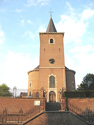
Sint-Truiden Abbey
Former Benedictine monastery in Belgium
Distance: Approx. 1775 meters
Latitude and longitude: 50.8164,5.1867
Sint-Truiden Abbey or St Trudo's Abbey (Dutch: Abdij van Sint-Truiden, Abdij van Sint-Trudo; French: Abbaye de Saint-Trond) is a former Benedictine monastery in Sint-Truiden (named after Saint Trudo) in the province of Limburg, Belgium. The abbey was founded in the 7th century and was one of the oldest and most powerful in the Low Countries. The town of Sint-Truiden grew up around it.
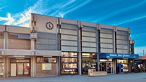
Sint-Truiden railway station
Railway station in Limburg, Belgium
Distance: Approx. 1346 meters
Latitude and longitude: 50.8175,5.17611111
Sint-Truiden railway station (Dutch: Station Sint-Truiden; French: Gare de Saint-Trond) is a railway station in Sint-Truiden, Limburg, Belgium. The station opened on 2 April 1838 and is located on railway line 21. The train services are operated by the National Railway Company of Belgium (NMBS/SNCB).

Siege of Zoutleeuw
1705 siege at Zoutleeuw during the War of the Spanish Succession
Distance: Approx. 5226 meters
Latitude and longitude: 50.833,5.104
The siege of Zoutleeuw or the siege of Léau (29 August 1705 – 5 September 1705) was a siege of the War of the Spanish Succession. Allied troops with 16 artillery pieces under the command of the English Captain general the Duke of Marlborough, besieged and captured the small French-held Brabantine fortified town of Zoutleeuw in the Spanish Netherlands.
Halle-Booienhoven
Place in Flanders, Belgium
Distance: Approx. 3733 meters
Latitude and longitude: 50.80611111,5.11305556
Halle-Booienhoven is a section of the municipality of Zoutleeuw, in the province of Flemish Brabant, Belgium. It was a municipality in its own right before the merger of the municipalities in 1977.
Peten Castle
Distance: Approx. 4328 meters
Latitude and longitude: 50.77184444,5.14049722
Peten Castle (also: Castle Peten-Van Halen) is a 19th-century castle in Velm (Sint-Truiden), Belgium.
Weather in this IP's area
broken clouds
13 Celsius
13 Celsius
12 Celsius
14 Celsius
1008 hPa
82 %
1008 hPa
1001 hPa
10000 meters
8.59 m/s
15.76 m/s
222 degree
53 %
07:40:00
19:17:38