Country:
 Germany
Region:
City:
Latitude and Longitude:
Time Zone:
Postal Code:
IP information under different IP Channel
ip-api
Country
Region
City
ASN
Time Zone
ISP
Blacklist
Proxy
Latitude
Longitude
Postal
Route
IPinfo
Country
Region
City
ASN
Time Zone
ISP
Blacklist
Proxy
Latitude
Longitude
Postal
Route
MaxMind
Country
Region
City
ASN
Time Zone
ISP
Blacklist
Proxy
Latitude
Longitude
Postal
Route
Luminati
Country
DEASN
Time Zone
Europe/Berlin
ISP
Heidelberg IT Management GmbH & Co.KG
Latitude
Longitude
Postal
db-ip
Country
Region
City
ASN
Time Zone
ISP
Blacklist
Proxy
Latitude
Longitude
Postal
Route
ipdata
Country
Region
City
ASN
Time Zone
ISP
Blacklist
Proxy
Latitude
Longitude
Postal
Route
Popular places and events near this IP address

SAP
German multinational enterprise-software company
Distance: Approx. 668 meters
Latitude and longitude: 49.2938038,8.639581
SAP SE (; German pronunciation: [ɛsʔaːˈpeː] ) is a German multinational software company based in Walldorf, Baden-Württemberg, Germany. It develops enterprise software to manage business operation and customer relations. The company is the world's largest enterprise resource planning (ERP) software vendor.

Walldorf
Town in Baden-Württemberg, Germany
Distance: Approx. 774 meters
Latitude and longitude: 49.3,8.65
Walldorf (German pronunciation: [ˈvalˌdɔʁf] ; South Franconian: Walldoaf) is a town in the Rhein-Neckar-Kreis district in the state of Baden-Württemberg in Germany. In the eighteenth century, Walldorf was the birthplace of John Jacob Astor, who emigrated and became a prominent fur trader in the newly independent United States, establishing a monopoly in North America. Concentrating on real estate acquisition and investment, and based in New York City, he grew even wealthier and was the patriarch of the wealthy and influential Astor family.

Wiesloch
Town in Baden-Württemberg, Germany
Distance: Approx. 3604 meters
Latitude and longitude: 49.29416667,8.69833333
Wiesloch (German: [ˈviːslɔx], locally [ˈvɪslɔx]; South Franconian: Wissloch) is a town in northern Baden-Württemberg, Germany. It is situated 13 kilometres south of Heidelberg. After Weinheim, Sinsheim and Leimen, it is the fourth largest town in the Rhein-Neckar-Kreis.

Nußloch
Municipality in Baden-Württemberg, Germany
Distance: Approx. 4721 meters
Latitude and longitude: 49.32361111,8.69388889
is a municipality in the Rhein-Neckar-Kreis (Baden-Württemberg), about 10 km south of Heidelberg. It is on a much traveled tourist route: Bergstraße ("Mountain Road") and Bertha Benz Memorial Route. The hamlet Maisbach also belongs to Nußloch.

Edingen-Neckarhausen
Municipality in Baden-Württemberg, Germany
Distance: Approx. 2569 meters
Latitude and longitude: 49.28333333,8.61666667
Edingen-Neckarhausen (Palatine German: Edinge-Neggerhause) is a municipality in the district of Rhein-Neckar-Kreis, in Baden-Württemberg, Germany. It is situated on the left bank of the Neckar.

Battle of Wiesloch (1632)
1632 battle of the Thirty Years' War
Distance: Approx. 1686 meters
Latitude and longitude: 49.29333333,8.67194444
The Battle of Wiesloch (German: Schlacht bei Wiesloch) occurred on 16 August 1632 during the Thirty Years' War near the German city of Wiesloch, south of Heidelberg. A Swedish army led by Count Gustav Horn fought an army of the Holy Roman Empire led by Count Ernesto Montecuccoli. The battle resulted in a Swedish victory.
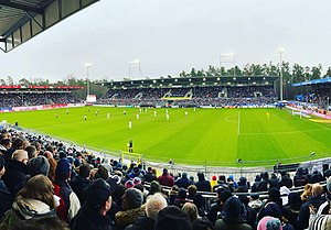
Hardtwaldstadion
Distance: Approx. 4356 meters
Latitude and longitude: 49.33222222,8.64777778
Hardtwaldstadion, currently known as GP Stadion am Hardtwald for sponsorship reasons, is a football stadium in Sandhausen, Germany. Situated in a small patch of forest near the Sandhausen town limits, it is the home stadium of local football team SV Sandhausen. The stadium is owned by the club.

Waldangelbach
River in Germany
Distance: Approx. 2640 meters
Latitude and longitude: 49.2915,8.685
Waldangelbach is a river of Baden-Württemberg, Germany. It flows into the Leimbach in Wiesloch. During 2017, a €2.4-million project took place to redevelop 210 metres of the Waldangelbach through the Mühlhausen city centre.
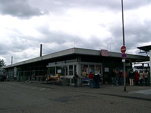
Wiesloch-Walldorf station
Railway station in Germany
Distance: Approx. 1150 meters
Latitude and longitude: 49.29083333,8.66416667
Wiesloch-Walldorf station is in the towns of Wiesloch and Walldorf in the German state of Baden-Württemberg. The station is classified by Deutsche Bahn as a category 3 station. Leimbach Park and the Wiesloch Feldbahn and Industrial Museum are located to the north of the station, with the headquarters of Heidelberger Druckmaschinen and SAP SE on the south-western side.

Leimbach Park
Distance: Approx. 1321 meters
Latitude and longitude: 49.29267,8.66691
The Leimbach Park (German: Leimbachpark or Park am Leimbach) is a linear park and 100-year flood prevention scheme opened in October 2016 in Wiesloch, Germany. It is part of a larger ecological enhancement of the River Leimbach. The park follows the River Leimbach downstream from Wiesloch to a larger 1.4-hectare (3.5-acre) area just north of Wiesloch-Walldorf station, part of the former Tonwaren-Industrie Wiesloch brickworks.

Wiesloch Feldbahn and Industrial Museum
Railway and industrial heritage museum in Wiesloch, Germany
Distance: Approx. 1531 meters
Latitude and longitude: 49.29807,8.66838
The Wiesloch Feldbahn and Industrial Museum (German: Feldbahn- und Industriemuseum Wiesloch, FIW) is a narrow-gauge railway and industrial heritage open-air museum established in 2001, at Wiesloch, Germany. The museum is centred around the former locomotive shed of the Tonwaren-Industrie Wiesloch (TIW) brickworks, and houses industrial equipment from large excavators to small machine tools, plus large and small locomotives. It is 650 metres (0.4 mi) north of Wiesloch-Walldorf station, lying between the River Leimbach and mainline Mannheim–Karlsruhe–Basel railway to the west, and the Bundesstraße 3 and REWE supermarket Group's south-west central warehouses to the east.

Tonwaren-Industrie Wiesloch
Distance: Approx. 1436 meters
Latitude and longitude: 49.296,8.668
Tonwaren-Industrie Wiesloch (TIW AG, originally Thonwaaren-Industrie Wiesloch GmbH, abbreviated Ton) was a brickworks which existed in Wiesloch, Germany between 1895 and 1989. It was one of the largest and most significant factories in Germany. The factory was located just north of Wiesloch-Walldorf station and was the largest employer in Wiesloch.
Weather in this IP's area
light rain
15 Celsius
15 Celsius
15 Celsius
16 Celsius
1014 hPa
84 %
1014 hPa
1001 hPa
10000 meters
0.7 m/s
0.92 m/s
251 degree
100 %
07:51:13
18:29:27