Country:
 Hungary
Region:
City:
Latitude and Longitude:
Time Zone:
Postal Code:
IP information under different IP Channel
ip-api
Country
Region
City
ASN
Time Zone
ISP
Blacklist
Proxy
Latitude
Longitude
Postal
Route
IPinfo
Country
Region
City
ASN
Time Zone
ISP
Blacklist
Proxy
Latitude
Longitude
Postal
Route
MaxMind
Country
Region
City
ASN
Time Zone
ISP
Blacklist
Proxy
Latitude
Longitude
Postal
Route
Luminati
Country
HURegion
fe
City
szekesfehervar
ASN
Time Zone
Europe/Budapest
ISP
Magyar Telekom plc.
Latitude
Longitude
Postal
db-ip
Country
Region
City
ASN
Time Zone
ISP
Blacklist
Proxy
Latitude
Longitude
Postal
Route
ipdata
Country
Region
City
ASN
Time Zone
ISP
Blacklist
Proxy
Latitude
Longitude
Postal
Route
Popular places and events near this IP address

Székesfehérvár
City with county rights in Central Transdanubia, Hungary
Distance: Approx. 819 meters
Latitude and longitude: 47.19555556,18.40888889
Székesfehérvár (Hungarian: [ˈseːkɛʃfɛheːrvaːr] ; German: Stuhlweißenburg [ʃtuːlˈvaɪsn̩bʊʁk] ; Latin: Alba Regia; Croatian: Stolni Biograd; Serbian: Стони Београд; Slovak: Stoličný Belehrad), known colloquially as Fehérvár (lit. 'white castle'), is a city in central Hungary, and the country's ninth-largest city. It is the regional capital of Central Transdanubia, and the centre of Fejér County and Székesfehérvár District. The area is an important rail and road junction between Lake Balaton and Lake Velence.

Fejér County (former)
County of the Kingdom of Hungary
Distance: Approx. 799 meters
Latitude and longitude: 47.18333333,18.41666667
Fejér (in Latin: comitatus Albensis) was an administrative county (comitatus) of the Kingdom of Hungary. Its territory, which was slightly smaller than that of present Fejér county, today in central Hungary. The capital of the county was Székesfehérvár.

Sóstói Stadion
Multi-purpose stadium in Székesfehérvár, Hungary
Distance: Approx. 1694 meters
Latitude and longitude: 47.17361111,18.41527778
Sóstói Stadion, formerly known as MOL Aréna Sóstó, (MOL Aréna Salt Lake) is a multi-purpose stadium in Székesfehérvár, Hungary, primarily used for football matches.

Central Transdanubia
Region in Hungary
Distance: Approx. 385 meters
Latitude and longitude: 47.18888889,18.41388889
Central Transdanubia (Hungarian: Közép-Dunántúl ['køzeːp 'dunaːntuːl]) is a statistical (NUTS 2) region of Hungary. The capital is Székesfehérvár. It is part of Transdanubia (NUTS 1) region.

Roman Catholic Diocese of Székesfehérvár
Roman Catholic diocese in Hungary
Distance: Approx. 397 meters
Latitude and longitude: 47.1917222,18.4097575
The Diocese of Székesfehérvár (Latin: Dioecesis Albae Regalensis) is a Latin Church diocese of the Catholic Church located in the city of Székesfehérvár in the ecclesiastical province of Esztergom-Budapest in Hungary.
Ifjabb Ocskay Gábor Ice Hall
Distance: Approx. 2980 meters
Latitude and longitude: 47.1856,18.4481
Ifjabb Ocskay Gábor Ice Hall is an indoor sporting arena in Székesfehérvár, Hungary. The arena has a capacity of 3,500 people and was opened in 1991. It is home to the Fehérvár AV19 ice hockey team, who play in the Austrian Hockey League.
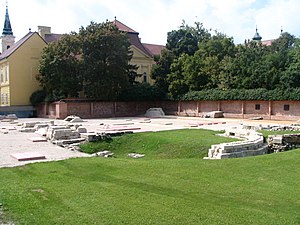
Basilica of the Assumption of the Blessed Virgin Mary
Distance: Approx. 413 meters
Latitude and longitude: 47.1917,18.4107
The Basilica of the Assumption of the Blessed Virgin Mary (Hungarian: Nagyboldogasszony-bazilika) was a basilica in Székesfehérvár (Latin: Alba Regia), Hungary. From the year 1000 until 1527, it was the site of the coronation of the Hungarian monarch. After the Ottomans occupied the city in 1543, coronations of the Hungarian monarch moved elsewhere; the building was extensively damaged in a fire in 1601.
Cathedral Basilica of Székesfehérvár
Church in Székesfehérvár, Hungary
Distance: Approx. 702 meters
Latitude and longitude: 47.189,18.4181
The Cathedral Basilica of St. Stephen the King (Hungarian: Szent István-székesegyház) also called Székesfehérvár Cathedral is the name given to a religious building of the Catholic Church in Hungary which serves as the cathedral of the city of Székesfehérvár. It is therefore the seat of the Diocese of Székesfehérvár (Dioecesis Albae Regalensis or Székesfehérvári egyházmegye), which was created in 1777 by bull "In universa gregis" of Pope Pius VI. The church was built in Baroque style, between 1758 and 1768.

Sóstói Stadion (1967)
Distance: Approx. 1687 meters
Latitude and longitude: 47.17369444,18.41536111
Sóstói Stadion was a multi-purpose stadium in Székesfehérvár, Hungary, primarily used for football matches. The stadium could hold 14,300 people and was the home of Nemzeti Bajnokság I club Videoton FC. The football arena was opened in 1967 and set its record attendance on 8 May 1985, when 40,000 fans flocked to see the UEFA Cup Final first leg between Videoton and Real Madrid.
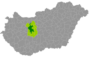
Székesfehérvár District
Districts of Hungary in Fejér
Distance: Approx. 217 meters
Latitude and longitude: 47.19,18.41
Székesfehérvár (Hungarian: Székesfehérvári járás) is a district in central-western part of Fejér County. Székesfehérvár is also the name of the town where the district seat is found. The district is located in the Central Transdanubia Statistical Region.
St. Stephen's Mausoleum
Memorial in Székesfehérvár, Hungary
Distance: Approx. 475 meters
Latitude and longitude: 47.19205,18.41162
St. Stephen's Mausoleum is a memorial building to Stephen I of Hungary in Székesfehérvár, Hungary. It was built in the late 1930s behind the excavated ruins of the Basilica of the Assumption of the Blessed Virgin Mary where Stephen had been originally buried, and contains the 11th-century sarcophagus of the deceased king.
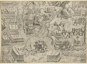
Siege of Székesfehérvár
Distance: Approx. 199 meters
Latitude and longitude: 47.18972222,18.41027778
The siege of Székesfehérvár also known as the siege of Stuhlweissenburg (French: Prise d'Albe-Royale, German: Belagerung von Stuhlweißenburg, Turkish: İstolni Belgrad) began on 4 September 1601 when an Imperial force sent by Holy Roman emperor Rudolf II, under the command of Frenchman Philippe Emmanuel de Lorraine, duc de Mercoeur, besieged the Hungarian fortress of Székesfehérvár occupied by the Ottomans since 1543. The battle resulted in a victory for the Imperial force.
Weather in this IP's area
clear sky
28 Celsius
27 Celsius
28 Celsius
28 Celsius
1014 hPa
33 %
1014 hPa
1002 hPa
10000 meters
5.47 m/s
7.28 m/s
144 degree
4 %
06:15:07
19:13:10