195.225.95.61 - IP Lookup: Free IP Address Lookup, Postal Code Lookup, IP Location Lookup, IP ASN, Public IP
Country:
Region:
City:
Location:
Time Zone:
Postal Code:
IP information under different IP Channel
ip-api
Country
Region
City
ASN
Time Zone
ISP
Blacklist
Proxy
Latitude
Longitude
Postal
Route
Luminati
Country
ASN
Time Zone
Europe/Warsaw
ISP
Vectra S.A.
Latitude
Longitude
Postal
IPinfo
Country
Region
City
ASN
Time Zone
ISP
Blacklist
Proxy
Latitude
Longitude
Postal
Route
IP2Location
195.225.95.61Country
Region
dolnoslaskie
City
walbrzych
Time Zone
Europe/Warsaw
ISP
Language
User-Agent
Latitude
Longitude
Postal
db-ip
Country
Region
City
ASN
Time Zone
ISP
Blacklist
Proxy
Latitude
Longitude
Postal
Route
ipdata
Country
Region
City
ASN
Time Zone
ISP
Blacklist
Proxy
Latitude
Longitude
Postal
Route
Popular places and events near this IP address

Wałbrzych
City in Lower Silesian Voivodeship, Poland
Distance: Approx. 531 meters
Latitude and longitude: 50.76666667,16.28333333
Wałbrzych (Polish: [ˈvawbʐɨx] ; German: Waldenburg; Silesian: Wałbrzich; Lower Silesian: Walmbrig or Walmbrich; Czech: Valbřich or Valdenburk) is a city located in the Lower Silesian Voivodeship, in southwestern Poland, seat of Wałbrzych County. Wałbrzych lies approximately 70 kilometres (43 mi) southwest of the voivodeship capital Wrocław and about 30 kilometres (19 miles) from the Czech border. Wałbrzych has the status of municipality.

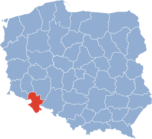
Wałbrzych Voivodeship
Former administrative division of Poland
Distance: Approx. 392 meters
Latitude and longitude: 50.768606,16.280916
Walbrzych Voivodeship (Polish: województwo wałbrzyskie) was a unit of administrative division and local government in Poland in the years 1975–1998, superseded by the Lower Silesian Voivodeship.

Wałbrzych County
County in Lower Silesian Voivodeship, Poland
Distance: Approx. 1330 meters
Latitude and longitude: 50.78333333,16.28333333
Wałbrzych County (Polish: powiat wałbrzyski; German: Waldenburg) is a unit of territorial administration and local government (powiat) in Lower Silesian Voivodeship, south-western Poland. It was created on January 1, 1999, as a result of the Polish local government reforms passed in 1998. The county covers an area of 514.2 square kilometres (198.5 sq mi).

Szczawno-Zdrój
Place in Lower Silesian Voivodeship, Poland
Distance: Approx. 3741 meters
Latitude and longitude: 50.79944444,16.255
Szczawno-Zdrój [ˈʂt͡ʂavnɔ ˈzdrui̯] (German: Bad Salzbrunn, until 1935 Ober Salzbrunn) is a spa town in Wałbrzych County, Lower Silesian Voivodeship, in south-western Poland.
Dziećmorowice
Village in Lower Silesian Voivodeship, Poland
Distance: Approx. 4980 meters
Latitude and longitude: 50.77,16.355
Dziećmorowice [d͡ʑɛt͡ɕmɔrɔˈvit͡sɛ] is a village in the administrative district of Gmina Walim, within Wałbrzych County, Lower Silesian Voivodeship, in south-western Poland. It lies approximately 11 kilometres (7 mi) north-west of Walim, 6 kilometres (4 mi) east of Wałbrzych, and 63 kilometres (39 mi) south-west of the regional capital Wrocław.
Rusinowa
Town in Poland
Distance: Approx. 3862 meters
Latitude and longitude: 50.762,16.3371
Rusinowa (former, German name: Reußendorf) is a town of Poland and now part of the town Wałbrzych. It was first mentioned in a Latin document Liber fundationis episcopatus Vratislaviensis from around 1305 as villa ottonis; since the end of the 14th century, it is called "Reußendorf"; in 1945 it was renamed "Rusinowa". The "castle" of Carl Robert Tielsch is located in Rusinowa; after the polish transition in 1945, it served as an orphanage and a school.
Nazi gold train
Urban legend
Distance: Approx. 5872 meters
Latitude and longitude: 50.82222222,16.30666667
The Nazi gold train or Wałbrzych gold train is an urban legend about a train laden with gold and treasure that was hidden by the Nazis in southwest Poland during the last days of World War II. The apocryphal tale claims the train full of valuables, including artwork, was concealed in a sealed-up rail tunnel or mine in the Central Sudetes by retreating Nazis. Despite numerous searches since 1945, including by the Polish Army during the Cold War, no evidence of the train, its tracks or treasure have ever been found. Historians believe the train never existed.
Sobięcin (Wałbrzych)
Distance: Approx. 3320 meters
Latitude and longitude: 50.7602,16.2406
Sobięcin ([sɔˈbjɛnt͡ɕin]; German: Hermsdorf, pronounced [ˈhɛʁmsˌdɔʁf] ; until 1929 "Niederhermsdorf", also "Nieder Hermsdorf") is part of Wałbrzych (German: "Waldenburg") in the Lower Silesian Voivodeship in Poland. Before 1950 Sobięcin was an independent rural community.

Mausoleum in Wałbrzych
Cenotaph in Wałbrzych Poland
Distance: Approx. 1160 meters
Latitude and longitude: 50.76472222,16.29694444
The Mausoleum in Wałbrzych, Schlesier-Ehrenmal (Silesian Monument of Glory) is a cenotaph commemorating 170,000 Silesians who died during World War I, victims of accidents in mines, and 25 local fighters of the National Socialist movement. It represents the style of monuments commemorating the victims of the war, while being at the same time an example of a propaganda monument to glory, typical of the monumental architecture of the Third Reich.

Biały Kamień, Wałbrzych
City district in Lower Silesia Voivodeship, Poland
Distance: Approx. 2412 meters
Latitude and longitude: 50.78138889,16.25388889
Biały Kamień (German: Weisstein, Latin: Albus Lapis), formerly an independent city, is a residential district and administrative unit located in the western part of Wałbrzych. It is best known for having the oldest record of coal mining in the Wałbrzych region, dated 1561, and for being the home of the football club Zagłębie Wałbrzych.

Old Mine in Wałbrzych
Museum in Poland
Distance: Approx. 1590 meters
Latitude and longitude: 50.77262,16.2618
The Old Mine Science and Art Centre in Wałbrzych is a museum located in the historic Julia Coal Mine. It was opened on 9 November 2014 after a major expansion of the Museum of Industry and Technology located there since 1999. The Old Mine Science and Art Centre was included in 2015 on the list of the European Route of Industrial Heritage (ERIH).

Statue of Ayrton Senna
Statue in Wałbrzych, Poland
Distance: Approx. 3315 meters
Latitude and longitude: 50.75805556,16.32638889
The statue of Ayrton Senna is a life-size bronze statue of Ayrton Senna in Wałbrzych, recalling him from the Hungaroring circuit. Senna is shown sitting, depicted on the tyre of a Formula 1 racing car.
Weather in this IP's area
broken clouds
-3 Celsius
-9 Celsius
-4 Celsius
-1 Celsius
1020 hPa
76 %
1020 hPa
962 hPa
10000 meters
4.74 m/s
10.67 m/s
278 degree
55 %


