195.225.94.22 - IP Lookup: Free IP Address Lookup, Postal Code Lookup, IP Location Lookup, IP ASN, Public IP
Country:
Region:
City:
Location:
Time Zone:
Postal Code:
ISP:
ASN:
language:
User-Agent:
Proxy IP:
Blacklist:
IP information under different IP Channel
ip-api
Country
Region
City
ASN
Time Zone
ISP
Blacklist
Proxy
Latitude
Longitude
Postal
Route
db-ip
Country
Region
City
ASN
Time Zone
ISP
Blacklist
Proxy
Latitude
Longitude
Postal
Route
IPinfo
Country
Region
City
ASN
Time Zone
ISP
Blacklist
Proxy
Latitude
Longitude
Postal
Route
IP2Location
195.225.94.22Country
Region
lubuskie
City
sieniawa zarska
Time Zone
Europe/Warsaw
ISP
Language
User-Agent
Latitude
Longitude
Postal
ipdata
Country
Region
City
ASN
Time Zone
ISP
Blacklist
Proxy
Latitude
Longitude
Postal
Route
Popular places and events near this IP address

Żary
Place in Lubusz Voivodeship, Poland
Distance: Approx. 5095 meters
Latitude and longitude: 51.63333333,15.13333333
Żary ([ˈʐarɨ] , Lower Sorbian: Žarow, German: Sorau, pronounced [ˈʒarɔw]) is a town in western Poland with 37,502 inhabitants (2019), situated in the Lubusz Voivodeship. It is the administrative seat of the Żary County and of the Gmina Żary within the county, though the town is not part of the gmina (commune). Żary is located in the east of the historic Lower Lusatia region, in the borderland with the Silesian lowlands and Greater Poland, roughly outlined by the Bóbr and Oder rivers.

Żary County
County in Lubusz Voivodeship, Poland
Distance: Approx. 5095 meters
Latitude and longitude: 51.63333333,15.13333333
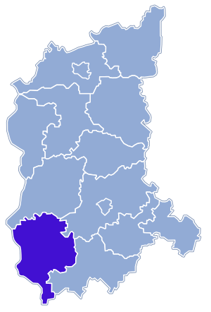
Żary County (Polish: powiat żarski) is a unit of territorial administration and local government (powiat) in Lubusz Voivodeship, western Poland, on the German border. It came into being on January 1, 1999, as a result of the Polish local government reforms passed in 1998. Its administrative seat and largest town is Żary, which lies 43 km (27 mi) south-west of Zielona Góra and 123 km (76 mi) south of Gorzów Wielkopolski.
Gmina Lipinki Łużyckie
Gmina in Lubusz Voivodeship, Poland
Distance: Approx. 3538 meters
Latitude and longitude: 51.64472222,15.00972222
Gmina Lipinki Łużyckie is a rural gmina (administrative district) in Żary County, Lubusz Voivodeship, in western Poland. Its seat is the village of Lipinki Łużyckie, which lies approximately 9 kilometres (6 mi) west of Żary and 48 km (30 mi) south-west of Zielona Góra. The gmina covers an area of 88.55 square kilometres (34.2 sq mi), and as of 2019 its total population is 3,366.
Gmina Żary
Gmina in Lubusz Voivodeship, Poland
Distance: Approx. 5095 meters
Latitude and longitude: 51.63333333,15.13333333
Gmina Żary is a rural gmina (administrative district) in Żary County, Lubusz Voivodeship, in western Poland. Its seat is the town of Żary, although the town is not part of the territory of the gmina. The gmina covers an area of 294.43 square kilometres (113.7 sq mi), and as of 2019 its total population is 12,343.
Brzostowa
Village in Lubusz Voivodeship, Poland
Distance: Approx. 5113 meters
Latitude and longitude: 51.66666667,15
Brzostowa [bʐɔsˈtɔva] is a village in the administrative district of Gmina Lipinki Łużyckie, within Żary County, Lubusz Voivodeship, in western Poland. It lies approximately 3 kilometres (2 mi) north of Lipinki Łużyckie, 10 km (6 mi) west of Żary, and 47 km (29 mi) south-west of Zielona Góra.
Górka, Lubusz Voivodeship
Village in Lubusz Voivodeship, Poland
Distance: Approx. 1316 meters
Latitude and longitude: 51.65,15.05
Górka [ˈɡurka] is a village in the administrative district of Gmina Lipinki Łużyckie, within Żary County, Lubusz Voivodeship, in western Poland. It lies approximately 3 kilometres (2 mi) east of Lipinki Łużyckie, 7 km (4 mi) west of Żary, and 45 km (28 mi) south-west of Zielona Góra.

Lipinki Łużyckie
Village in Lubusz Voivodeship, Poland
Distance: Approx. 3538 meters
Latitude and longitude: 51.64472222,15.00972222
Lipinki Łużyckie (Polish pronunciation: [liˈpiŋkʲi wuˈʐɨtskʲɛ]) (German: Linderode) is a village in Żary County, Lubusz Voivodeship, in western Poland. It is the seat of the gmina (administrative district) called Gmina Lipinki Łużyckie. It lies approximately 9 kilometres (6 mi) west of Żary and 48 km (30 mi) south-west of Zielona Góra.
Sieciejów
Village in Lubusz Voivodeship, Poland
Distance: Approx. 4227 meters
Latitude and longitude: 51.66666667,15.01666667
Sieciejów [ɕɛˈt͡ɕɛjuf] is a village in the administrative district of Gmina Lipinki Łużyckie, within Żary County, Lubusz Voivodeship, in western Poland. It lies approximately 9 kilometres (6 mi) north-west of Żary and 46 km (29 mi) south-west of Zielona Góra.
Suchleb
Village in Lubusz Voivodeship, Poland
Distance: Approx. 4922 meters
Latitude and longitude: 51.61666667,15
Suchleb [ˈsuxlɛp] is a village in the administrative district of Gmina Lipinki Łużyckie, within Żary County, Lubusz Voivodeship, in western Poland. It lies approximately 10 kilometres (6 mi) west of Żary and 50 km (31 mi) south-west of Zielona Góra.
Drożków
Village in Lubusz Voivodeship, Poland
Distance: Approx. 4832 meters
Latitude and longitude: 51.68333333,15.06666667
Drożków [ˈdrɔʂkuf] is a village in the administrative district of Gmina Żary, within Żary County, Lubusz Voivodeship, in western Poland. It lies approximately 8 kilometres (5 mi) north-west of Żary and 42 km (26 mi) south-west of Zielona Góra.
Grabik, Lubusz Voivodeship
Village in Lubusz Voivodeship, Poland
Distance: Approx. 2949 meters
Latitude and longitude: 51.65,15.1
Grabik [ˈɡrabik] is a village in the administrative district of Gmina Żary, within Żary County, Lubusz Voivodeship, in western Poland. It lies approximately 3 kilometres (2 mi) north-west of Żary and 43 km (27 mi) south-west of Zielona Góra. In village play local football team Sparta Grabik which is currently playing at Klasa A level.

Miłowice, Lubusz Voivodeship
Village in Lubusz Voivodeship, Poland
Distance: Approx. 4521 meters
Latitude and longitude: 51.6,15.05
Miłowice [miwɔˈvit͡sɛ] is a village in the administrative district of Gmina Żary, within Żary County, Lubusz Voivodeship, in western Poland. It lies approximately 7 kilometres (4 mi) south-west of Żary and 50 km (31 mi) south-west of Zielona Góra.
Weather in this IP's area
clear sky
3 Celsius
0 Celsius
3 Celsius
3 Celsius
1024 hPa
85 %
1024 hPa
1007 hPa
10000 meters
2.93 m/s
4.35 m/s
123 degree
5 %