195.214.212.115 - IP Lookup: Free IP Address Lookup, Postal Code Lookup, IP Location Lookup, IP ASN, Public IP
Country:
Region:
City:
Location:
Time Zone:
Postal Code:
IP information under different IP Channel
ip-api
Country
Region
City
ASN
Time Zone
ISP
Blacklist
Proxy
Latitude
Longitude
Postal
Route
Luminati
Country
ASN
Time Zone
Europe/Kyiv
ISP
Netassist Limited
Latitude
Longitude
Postal
IPinfo
Country
Region
City
ASN
Time Zone
ISP
Blacklist
Proxy
Latitude
Longitude
Postal
Route
IP2Location
195.214.212.115Country
Region
trnavsky kraj
City
trnava
Time Zone
Europe/Bratislava
ISP
Language
User-Agent
Latitude
Longitude
Postal
db-ip
Country
Region
City
ASN
Time Zone
ISP
Blacklist
Proxy
Latitude
Longitude
Postal
Route
ipdata
Country
Region
City
ASN
Time Zone
ISP
Blacklist
Proxy
Latitude
Longitude
Postal
Route
Popular places and events near this IP address

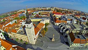
Trnava
City in Slovakia
Distance: Approx. 85 meters
Latitude and longitude: 48.3775,17.58833333
Trnava (Slovak pronunciation: [ˈtr̩naʋa] , German: Tyrnau, German: [ˈtʏrnaʊ̯] ; Hungarian: Nagyszombat [ˈnɒcsombɒt], also known by other alternative names) is a city in western Slovakia, 47 km (29 mi) to the northeast of Bratislava, on the Trnávka river. It is the capital of the Trnava Region and the Trnava District. It is the seat of a Roman Catholic archbishopric (1541–1820 and then again since 1977).

Trnava District
District in Trnava Region, Slovakia
Distance: Approx. 715 meters
Latitude and longitude: 48.37361111,17.595
Trnava District (Slovak: okres Trnava) is a district in the Trnava Region of Slovakia. In its present borders the district was established in 1996. Before that date Hlohovec district was a part of it.
Hrnčiarovce nad Parnou
Municipality in Slovakia
Distance: Approx. 3407 meters
Latitude and longitude: 48.35,17.56666667
Hrnčiarovce nad Parnou (Hungarian: Gerencsér) is a village and municipality of the Trnava District in the Trnava region of Slovakia. The village is 5 km southwest from the centre of the town of Trnava.

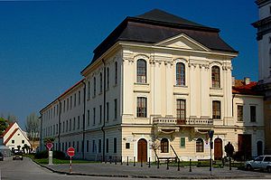
University of Trnava
University in Slovakia
Distance: Approx. 260 meters
Latitude and longitude: 48.3797181,17.5867669
The University of Trnava (in Trnava) (Slovak: Trnavská univerzita v Trnave) is based in Trnava, in the west of Slovakia. The university's presence in the town has historical antecedents as the University of Nagyszombat was operating there throughout the 17th and 18th century (present day Eötvös Loránd University in Budapest).

Roman Catholic Archdiocese of Trnava
Roman Catholic archdiocese in Slovakia
Distance: Approx. 344 meters
Latitude and longitude: 48.3804,17.5883
The Archdiocese of Trnava (Slovak: Trnavská arcidiecéza, Latin: Archidioecesis Tyrnaviensis) is a Latin Catholic archdiocese in western Slovakia including bigger part of the Trnava, and parts of Nitra and Trenčín regions. It has its seat in Trnava. Although it is an archdiocese, it is not a metropolitan and is instead a suffragan of Bratislava.

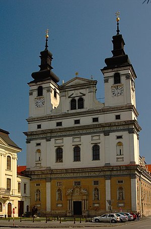
St. John the Baptist Cathedral (Trnava)
Church in Trnava, Slovakia
Distance: Approx. 365 meters
Latitude and longitude: 48.3806,17.5883
St. John the Baptist Cathedral (Slovak: Katedrála svätého Jána Krstiteľa, Hungarian: Keresztelő Szent János székesegyház) is one of the most significant historic monuments of Trnava, western Slovakia.
City Tower (Trnava)
Distance: Approx. 147 meters
Latitude and longitude: 48.3778,17.5853
The City Tower (in Slovak Mestská veža) is one of the most important historic monuments of Trnava, Slovakia. The tower's construction began on 28 July 1574. In 1666 and 1683 the tower was affected by fire and since then it has remained without a roof.

Saint Nicolas Church, Trnava
Church in Trnava, Slovakia
Distance: Approx. 407 meters
Latitude and longitude: 48.37888889,17.59222222
Saint Nicolas Church or Basilica of Saint Nicholas (Slovak: Bazilika Svätého Mikuláša, also known as Hrubý Kostol, meaning "main/big church") is a Gothic/Baroque church in Trnava, Slovakia. In 2009 Pope Benedict XVI granted the parish church of St. Nicolas the honourable title of minor basilica.
Status Quo Ante Synagogue (Trnava)
Former synagogue in Trnava, Slovakia
Distance: Approx. 225 meters
Latitude and longitude: 48.378,17.5901
The Status Quo Ante Synagogue (Slovak: Synagóga status quo ante) is a former Status Quo Jewish congregation and synagogue, located on Halenárska Street in Trnava, Slovakia. The building has been used as an arts center since 2016.
Stellantis Trnava Plant
Slovakian car manufacturing and assembly plant
Distance: Approx. 3543 meters
Latitude and longitude: 48.36138889,17.62861111
The Stellantis Trnava Plant is a major car plant in Slovakia and the most recently established Stellantis plant in Europe. It is located directly to the south-east of Trnava, approximately 60 kilometres (37 mi) from Bratislava and the frontier with Austria to the south-west.

Anton Malatinský Stadium
Football stadium located in Trnava, Slovakia
Distance: Approx. 560 meters
Latitude and longitude: 48.37333333,17.59166667
Anton Malatinský Stadium (Slovak: Štadión Antona Malatinského) is a football stadium located in Trnava, Slovakia, which is the home ground of the local football club Spartak Trnava. The stadium was completely renovated in 2013–2015 and has an all-seated capacity of 18,200 which makes it the second-largest football stadium in Slovakia. On 14 January 1998, the stadium was named in the honour of former footballer and manager Anton Malatinský, who died in 1992.
University of Ss. Cyril and Methodius
University in Slovakia
Distance: Approx. 637 meters
Latitude and longitude: 48.383,17.589
University of Ss. Cyril and Methodius in Trnava (Slovak: Univerzita sv. Cyrila a Metoda v Trnave) is a public university located in Trnava, Slovakia.
Weather in this IP's area
clear sky
-1 Celsius
-4 Celsius
-1 Celsius
-1 Celsius
1022 hPa
91 %
1022 hPa
1003 hPa
10000 meters
2.4 m/s
3.05 m/s
128 degree
3 %


