Country:
Region:
City:
Latitude and Longitude:
Time Zone:
Postal Code:
IP information under different IP Channel
ip-api
Country
Region
City
ASN
Time Zone
ISP
Blacklist
Proxy
Latitude
Longitude
Postal
Route
Luminati
Country
ASN
Time Zone
Europe/Berlin
ISP
WIIT AG
Latitude
Longitude
Postal
IPinfo
Country
Region
City
ASN
Time Zone
ISP
Blacklist
Proxy
Latitude
Longitude
Postal
Route
db-ip
Country
Region
City
ASN
Time Zone
ISP
Blacklist
Proxy
Latitude
Longitude
Postal
Route
ipdata
Country
Region
City
ASN
Time Zone
ISP
Blacklist
Proxy
Latitude
Longitude
Postal
Route
Popular places and events near this IP address

Düsseldorf-Rath
City district of Düsseldorf, Germany
Distance: Approx. 245 meters
Latitude and longitude: 51.26611111,6.81416667
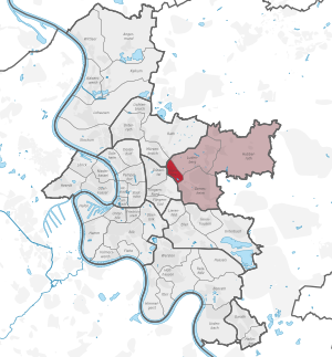
Rath is a quarter in northern Düsseldorf, part of Borough 6. It is about 5 km northeast of the city center, near the airport. It has an area of 10.42 km2 (4.02 sq mi), and 20,483 inhabitants (2020).

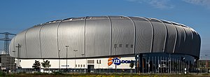
PSD Bank Dome
Sports arena in Düsseldorf, Germany
Distance: Approx. 691 meters
Latitude and longitude: 51.27194444,6.81138889
The PSD Bank Dome is a multi-use indoor arena in Düsseldorf, Germany, it opened in 2006. The arena has a capacity of 15,151 people and 14,282 people for hockey matches.
Lichtenbroich
Stadtteil of Düsseldorf in North Rhine-Westphalia, Germany
Distance: Approx. 2372 meters
Latitude and longitude: 51.26666667,6.78333333
Lichtenbroich is an urban quarter of Düsseldorf, part of Borough 6. It is in the north of the city, neighbouring to Lohausen, Mörsenbroich and the airport. It has an area of 2.14 km2 (0.83 sq mi), and 6,104 inhabitants (2020).

Düsseldorf-Grafenberg
City district of Düsseldorf, Germany
Distance: Approx. 2957 meters
Latitude and longitude: 51.24083333,6.82472222
Grafenberg is an urban quarter of Düsseldorf, part of Borough 7. It borders to Gerresheim, Ludenberg, Flingern and Düsseltal. It has an area of 0.91 km2 (0.35 sq mi), and 5,845 inhabitants (2020).

Unterrath
City district of Düsseldorf, Germany
Distance: Approx. 2008 meters
Latitude and longitude: 51.27361111,6.79055556
Unterrath is one of the 50 quarters of the City of Düsseldorf, Germany. Located in the north of the city, it is part of Borough 6. It is near Düsseldorf Airport.

Mörsenbroich
City district of Düsseldorf, Germany
Distance: Approx. 1458 meters
Latitude and longitude: 51.25527778,6.80805556
Mörsenbroich is an urban quarter of Düsseldorf, part of Borough 6. It borders on Unterrath, Rath, Derendorf, Grafenberg and Düsselthal. It has an area of 2.64 km2 (1.02 sq mi), and 18,021 inhabitants (2020).

Arag-Tower
31-storey, 124.9 m (410 ft) office skyscraper, in Düsseldorf, Germany
Distance: Approx. 2226 meters
Latitude and longitude: 51.25,6.80055556
ARAG Tower is a 31-storey, 124.9 m (410 ft) office skyscraper, in the northern district of Mörsenbroich, Düsseldorf, Germany. The tower is the tallest building in Düsseldorf, and it serves as headquarters for the leading legal insurer worldwide, the ARAG Group. The architect firms of Foster + Partners and Rhode Kellermann Wawrowsky collaborated on the project, and Hochtief project management.

Düsseldorf-Rath Mitte station
Railway station in Düsseldorf, Germany
Distance: Approx. 923 meters
Latitude and longitude: 51.26111111,6.80805556
Düsseldorf-Rath Mitte is a railway station situated at Rath, Düsseldorf in western Germany. It is served by the S6 line of Rhine-Ruhr S-Bahn. Interchange to Stadtbahn line U71 and Tram line 701, both operated by the Rheinbahn, is possible.

Düsseldorf-Rath station
Railway station in Düsseldorf, Germany
Distance: Approx. 427 meters
Latitude and longitude: 51.263876,6.820948
Düsseldorf-Rath is a railway station situated at Rath, Düsseldorf in western Germany. It is served by the S6 line of Rhine-Ruhr S-Bahn. It is also served by line U71 of the Düsseldorf Stadtbahn and Tram line 701.

7th Panzer Division (Bundeswehr)
Military unit
Distance: Approx. 2189 meters
Latitude and longitude: 51.247357,6.818819
The 7th Panzer Division or Westphalian Panzer Division (German: 7. Panzerdivision or Westfälische Panzerdivision) was a major formation in the German Army (Heer) within the German Armed Forces or Bundeswehr whose headquarters was for many years in Lippstadt und Unna and, finally in Düsseldorf. Until its dissolution in 2006 it was seen as the "backbone of the Army" or the "spearhead of the German Army".

Rochusclub Düsseldorfer Tennisclub
Tennis club in Dusseldorf, Germany
Distance: Approx. 2033 meters
Latitude and longitude: 51.25,6.82805556
The Rochusclub Düsseldorfer Tennisclub is a tennis venue that is part of the Rochusclub sports complex located in Düsseldorf in Germany. The club was founded in 1898, before moving to a new location in 1929 where it has remained. The club has hosted the following tennis tournaments: (i) the Düsseldorf International (1905-1969); (ii) the Düsseldorf Grand Prix (1970-1977); and (iii) the ATP World Team Cup (1975-2012) The Power Horse Cup was created to host these events since 2013, replacing the old venue.

Borough 6 (Düsseldorf)
Borough of Düsseldorf in North Rhine-Westphalia, Germany
Distance: Approx. 245 meters
Latitude and longitude: 51.26611111,6.81416667
Borough 6 (German: Stadtbezirk 6) is a northern borough of Düsseldorf, the state capital of North Rhine-Westphalia, Germany. The borough covers an area of 19.63 square kilometres and (as of December 2020) has about 67,000 inhabitants. The borough borders with the Düsseldorf boroughs 1, 2, 5 and 7.
Weather in this IP's area
mist
9 Celsius
8 Celsius
9 Celsius
10 Celsius
1027 hPa
96 %
1027 hPa
1022 hPa
5000 meters
2.24 m/s
2.68 m/s
291 degree
100 %
07:48:48
16:45:50
