Country:
Region:
City:
Latitude and Longitude:
Time Zone:
Postal Code:
IP information under different IP Channel
ip-api
Country
Region
City
ASN
Time Zone
ISP
Blacklist
Proxy
Latitude
Longitude
Postal
Route
Luminati
Country
ASN
Time Zone
Asia/Jerusalem
ISP
S.P.D. Hosting LTD
Latitude
Longitude
Postal
IPinfo
Country
Region
City
ASN
Time Zone
ISP
Blacklist
Proxy
Latitude
Longitude
Postal
Route
db-ip
Country
Region
City
ASN
Time Zone
ISP
Blacklist
Proxy
Latitude
Longitude
Postal
Route
ipdata
Country
Region
City
ASN
Time Zone
ISP
Blacklist
Proxy
Latitude
Longitude
Postal
Route
Popular places and events near this IP address

Holon Institute of Technology
Academic college in Israel
Distance: Approx. 2633 meters
Latitude and longitude: 32.01432222,34.77381944
Holon Institute of Technology (HIT) is an Israeli independent public college primarily offering undergrad education. It also has a Master's degree program and does research in the fields of science, applied mathematics, engineering, digital medical technologies, instructional technologies, industrial engineering/technology management and design. It is funded by Israel's Council for Higher Education.

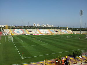
Haberfeld Stadium
Distance: Approx. 2543 meters
Latitude and longitude: 31.97499444,34.75283889
Haberfeld Stadium (Hebrew: אצטדיון הברפלד, Itztadion Haberfeld; also known as the Superland Stadium) is a multi-purpose stadium in Rishon LeZion, Israel. It is currently used mostly for football matches and is the home stadium of Hapoel Rishon LeZion. The stadium holds 6,000 and was built in 1993.

Bat Yam Municipal Stadium
Distance: Approx. 1922 meters
Latitude and longitude: 32.003045,34.758167
The Bat Yam Municipal Stadium (Hebrew: האצטדיון העירוני בת ים, HaEtztadion HaIroni Bat Yam) is a football stadium in the Tel Aviv District city of Bat Yam, Israel. It has a capacity of 3,100. Opened in 1991, the stadium is located in the south-east of Bat Yam, and replaced the former municipal stadium that was in the south-west.

College of Management Academic Studies
Institute of higher education in Israel
Distance: Approx. 2266 meters
Latitude and longitude: 31.97035,34.772104
The College of Management Academic Studies, a college located in the city of Rishon LeZion, Israel, is the largest college in Israel. The College has an additional campus in the city of Bnei Brak. Founded in 1978, COLMAN is the first non-subsidized, not-for-profit research academic institution in Israel to be recognized and certified by the Council for Higher Education in Israel.
Holon Children's Museum
Children's museum in Holon, Israel
Distance: Approx. 2763 meters
Latitude and longitude: 32.00305556,34.79777778
Holon Children's Museum (Hebrew: מוזיאון הילדים חולון) is a children's museum in Holon, Israel.
Talpiot College of Education
Distance: Approx. 2258 meters
Latitude and longitude: 32.00945278,34.76328889
The Talpiot College of Education (המכללה האקדמית תלפיות) is a religious teacher training college in Holon, Israel. It prepares teachers “in the spirit of the Mamlachti dati (state religious) education system”. It was founded in 1937 by Jacob Alishkovsky and was originally called the "Talpiot Beit Midrash for Kindergarten Teachers".

Design Museum Holon
Museum in Israel
Distance: Approx. 2308 meters
Latitude and longitude: 32.01096111,34.77760833
Design Museum Holon is the first museum in Israel dedicated to design.

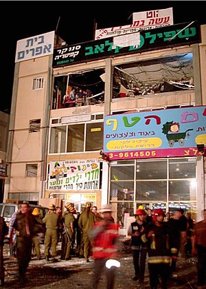
2002 Rishon LeZion bombing
Palestinian suicide attack in Israel
Distance: Approx. 291 meters
Latitude and longitude: 31.9918,34.7696
The 2002 Rishon LeZion bombing was a suicide bombing which occurred on 7 May 2002 at a crowded game club located in the new industrial area of Rishon Lezion, Israel. 16 people were killed in the attack and 55 were injured. The Islamic militant group Hamas claimed responsibility for the attack.

Rishon LeZion–Moshe Dayan railway station
Israel Railways station in Rishon LeZion
Distance: Approx. 1450 meters
Latitude and longitude: 31.9879,34.7574
The Rishon LeZion–Moshe Dayan railway station is an Israel Railways station in Rishon LeZion. The station is located adjacent to the Moshe Dayan Interchange on the Ayalon Highway. It serves as the terminus of a new suburban passenger line serving the cities of Holon, Bat Yam, and Rishon LeZion in southern Gush Dan.

Bat Yam–Yoseftal railway station
Railway station in Israel
Distance: Approx. 2880 meters
Latitude and longitude: 32.015,34.76194444
Bat Yam–Yoseftal railway station is a railway station on the Rosh HaAyin–Beersheba line. It is located at the Yoseftal interchange on the Ayalon Highway, on the border between Bat Yam and Holon, just south of Tel Aviv, Israel.

Bat Yam–Komemiyut railway station
Railway station in Israel
Distance: Approx. 1664 meters
Latitude and longitude: 32.00083333,34.75944444
Bat Yam–Komemiyut railway station is a railway station on the Rosh HaAyin–Beersheba line in Israel. It is located at the Komemiyut interchange of the Ayalon Highway, on the border between Bat Yam and Holon.

Holon Toto Hall
Indoor arena in Holon, Israel
Distance: Approx. 2695 meters
Latitude and longitude: 32.00222222,34.7975
Holon Toto Hall is an indoor arena that is located in the Tel Aviv District city of Holon, Israel. The arena is mainly used to host basketball games. It has a seating capacity of 5,500.
Weather in this IP's area
light rain
16 Celsius
15 Celsius
15 Celsius
17 Celsius
1014 hPa
75 %
1014 hPa
1008 hPa
10000 meters
3.09 m/s
160 degree
3 %
06:12:35
16:39:59
