Country:
 Hungary
Region:
City:
Latitude and Longitude:
Time Zone:
Postal Code:
IP information under different IP Channel
ip-api
Country
Region
City
ASN
Time Zone
ISP
Blacklist
Proxy
Latitude
Longitude
Postal
Route
IPinfo
Country
Region
City
ASN
Time Zone
ISP
Blacklist
Proxy
Latitude
Longitude
Postal
Route
MaxMind
Country
Region
City
ASN
Time Zone
ISP
Blacklist
Proxy
Latitude
Longitude
Postal
Route
Luminati
Country
HURegion
va
City
szombathely
ASN
Time Zone
Europe/Budapest
ISP
Invitech ICT Services Kft.
Latitude
Longitude
Postal
db-ip
Country
Region
City
ASN
Time Zone
ISP
Blacklist
Proxy
Latitude
Longitude
Postal
Route
ipdata
Country
Region
City
ASN
Time Zone
ISP
Blacklist
Proxy
Latitude
Longitude
Postal
Route
Popular places and events near this IP address

Szombathely
City with county rights in Western Transdanubia, Hungary
Distance: Approx. 867 meters
Latitude and longitude: 47.23512,16.62191
Szombathely (Hungarian pronunciation: [ˈsombɒthɛj]; German: Steinamanger, German pronunciation: [ʃtaɪ̯naˈmaŋɐ] ; also see names) is the 10th largest city in Hungary. It is the administrative centre of Vas County in the west of the country, located near the border with Austria. Szombathely lies by the streams Perint and Gyöngyös (literally "pearly"), where the Alpokalja (Lower Alps) mountains meet the Little Hungarian Plain.

Rohonci út
Former multi-purpose stadium in Hungary
Distance: Approx. 1130 meters
Latitude and longitude: 47.234762,16.607117
Stadion Rohonci Út (Hungarian: Rohonci úti stadion) was a multi-purpose stadium in Szombathely, Hungary. It was home to Szombathelyi Haladás. The stadium was able to hold 12,500 people and was built in 1923.
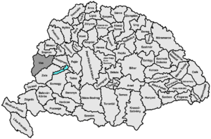
Vas County (former)
County of the Kingdom of Hungary
Distance: Approx. 624 meters
Latitude and longitude: 47.23333333,16.61666667
Vas (Latin: Comitatus Castrifèrreus, German: Eisenburg, Slovene: Železna županija or Železna) was an administrative county (comitatus) of the Kingdom of Hungary. Its territory is now divided between Hungary, Austria and Slovenia.

Torony
Place in Vas, Hungary
Distance: Approx. 6190 meters
Latitude and longitude: 47.23626,16.53706
Torony (lit. "tower") is a village in Vas county, Hungary.
Sé, Hungary
Place in Vas, Hungary
Distance: Approx. 4971 meters
Latitude and longitude: 47.2429,16.55611
Sé (German: Scheibing) is a village in Vas county, in the west of Hungary, located near the border with Austria.
Roman Catholic Diocese of Szombathely
Catholic diocese in Hungary
Distance: Approx. 326 meters
Latitude and longitude: 47.2307202,16.6183509
The Diocese of Szombathely (Latin: Dioecesis Sabariensis) is a Latin suffragan diocese in the ecclesiastical province of the Metropolitan Veszprém in Hungary. Its cathedral episcopal see is Szombathely Cathedral (Hungarian: Sarlósboldogasszony székesegyházi), dedicated to the Visitation of Our Lady, in the city of Szombathely.
Gencsapáti
Place in Western Transdanubia, Hungary
Distance: Approx. 6330 meters
Latitude and longitude: 47.28333333,16.6
Gencsapáti is a village in Vas county, Hungary.
Nárai
Place in Western Transdanubia, Hungary
Distance: Approx. 4964 meters
Latitude and longitude: 47.2,16.56666667
Nárai is a village in Vas county, Hungary.
Söpte
Place in Western Transdanubia, Hungary
Distance: Approx. 6638 meters
Latitude and longitude: 47.28333333,16.65
Söpte is a village in Vas county, Hungary.
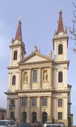
Szombathely Cathedral
Church in Szombathely, Hungary
Distance: Approx. 392 meters
Latitude and longitude: 47.2313,16.6174
The Our Lady of the Visitation Cathedral (Hungarian: Sarlósboldogasszony székesegyházi) also called Szombathely Cathedral or Cathedral of the Visitation of Our Lady is the name given to a religious building affiliated with the Catholic Church in the city of Szombathely in Hungary, it is the principal church of the Diocese of Szombathely. With the establishment of a diocese in 1777 the construction of a cathedral became necessary. A Baroque building in classical style began in 1791 and was completed in 1797.
Haladás Sportkomplexum
Distance: Approx. 1130 meters
Latitude and longitude: 47.234762,16.607117
Haladás Sportkomplexum (Hungarian: Haladás Sportkomplexum) is a multi-purpose stadium in Szombathely, Hungary. It replaced Szombathelyi Haladás's former stadium, Rohonci úti Stadion.
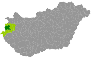
Szombathely District
Districts of Hungary in Vas
Distance: Approx. 288 meters
Latitude and longitude: 47.23,16.62
Szombathely (Hungarian: Szombathelyi járás) is a district in central-western part of Vas County. Szombathely is also the name of the town where the district seat is found. The district is located in the Western Transdanubia Statistical Region.
Weather in this IP's area
clear sky
26 Celsius
26 Celsius
26 Celsius
26 Celsius
1014 hPa
50 %
1014 hPa
989 hPa
10000 meters
3.44 m/s
5.01 m/s
191 degree
06:22:15
19:20:22