Country:
 Netherlands
Region:
City:
Latitude and Longitude:
Time Zone:
Postal Code:
IP information under different IP Channel
ip-api
Country
Region
City
ASN
Time Zone
ISP
Blacklist
Proxy
Latitude
Longitude
Postal
Route
IPinfo
Country
Region
City
ASN
Time Zone
ISP
Blacklist
Proxy
Latitude
Longitude
Postal
Route
MaxMind
Country
Region
City
ASN
Time Zone
ISP
Blacklist
Proxy
Latitude
Longitude
Postal
Route
Luminati
Country
NLASN
Time Zone
Europe/Amsterdam
ISP
ATGS-MMD-AS
Latitude
Longitude
Postal
db-ip
Country
Region
City
ASN
Time Zone
ISP
Blacklist
Proxy
Latitude
Longitude
Postal
Route
ipdata
Country
Region
City
ASN
Time Zone
ISP
Blacklist
Proxy
Latitude
Longitude
Postal
Route
Popular places and events near this IP address
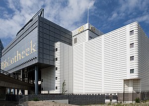
Royal Library of the Netherlands
National Library of the Netherlands
Distance: Approx. 1015 meters
Latitude and longitude: 52.08065833,4.32676389
The Royal Library of the Netherlands (Dutch: Koninklijke Bibliotheek or KB; Royal Library) is the national library of the Netherlands, based in The Hague, founded in 1798. The KB collects everything that is published in and concerning the Netherlands, from medieval literature to today's publications. About 7 million publications are stored in the stockrooms, including books, newspapers, magazines and maps.
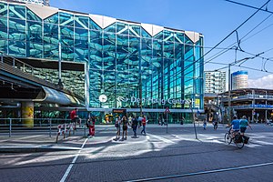
Den Haag Centraal railway station
Railway station in The Hague
Distance: Approx. 885 meters
Latitude and longitude: 52.08166667,4.32916667
Den Haag Centraal (Dutch pronunciation: [dɛn ˌɦaːx sɛnˈtraːl]; English: "The Hague Central") is the largest railway station in the city of The Hague in South Holland, Netherlands, and with twelve tracks, the largest terminal station in the Netherlands. The railway station opened in 1973, adjacent to its predecessor: Den Haag Staatsspoor, which was subsequently demolished. It is the western terminus of the Gouda–Den Haag railway.

Den Haag Laan van NOI railway station
Railway station in The Hague, Netherlands
Distance: Approx. 117 meters
Latitude and longitude: 52.07888889,4.34305556
Den Haag Laan van NOI railway station is a railway station in the Netherlands, on the border between The Hague and the town of Voorburg. It is served by the Nederlandse Spoorwegen (Dutch railway) and by the RandstadRail light-rail network. The station is named after the road on which it is located, Laan van Nieuw Oost-Indië, which literally translates as New East Indies Avenue, but probably refers to a former inn called Nieuw Oosteinde (New East End).

Beatrixkwartier
Neighbourhood of The Hague in South Holland, Netherlands
Distance: Approx. 255 meters
Latitude and longitude: 52.07833333,4.33777778
The Beatrixkwartier (literally Beatrix Quarter in Dutch) is a modern financial district in The Hague, near the Central Station, in the Bezuidenhout district. The name was chosen when the Beatrixlaan was renewed. Officially this area is the strip of buildings along the Utrechtsebaan from Nationale Nederlanden to the Palace of Justice.

Netherlands Institute for Art History
Dutch national library of art history and holder of Dutch art history thesaurus
Distance: Approx. 991 meters
Latitude and longitude: 52.0816,4.3275
The Netherlands Institute for Art History or RKD (Dutch: RKD-Nederlands Instituut voor Kunstgeschiedenis), previously Rijksbureau voor Kunsthistorische Documentatie (RKD), is located in The Hague and is home to the largest art history center in the world. The center specializes in documentation, archives, and books on Western art from the late Middle Ages until modern times. All of this is open to the public, and much of it has been digitized and is available on their website.

Beatrixkwartier RandstadRail station
RandstadRail station in The Hague
Distance: Approx. 467 meters
Latitude and longitude: 52.08,4.33472222
Beatrixkwartier is a RandstadRail station in the Beatrixkwartier district in The Hague, Netherlands.

Bombing of the Bezuidenhout
1945 British military error during WWII
Distance: Approx. 1034 meters
Latitude and longitude: 52.08805556,4.34472222
The bombing of the Bezuidenhout (Dutch: bombardement op het Bezuidenhout) took place on March 3, 1945, when the Royal Air Force mistakenly bombed the Bezuidenhout neighborhood in the Dutch city of The Hague, resulting in the death of 532 people.

Meadows near Rijswijk and the Schenkweg
Location painted by Vincent van Gogh
Distance: Approx. 804 meters
Latitude and longitude: 52.078441,4.329637
Meadows near Rijswijk and the Schenkweg is a watercolor by the Dutch painter Vincent van Gogh that he made in January 1882, shortly after taking up residence in The Hague. It shows the view from his studio window on the outer reaches of The Hague at the Schenkweg, then undergoing a period of urban development. The view is across the Schenkweg ditch towards the newly constructed Rijnspoor railway station, built for the Utrecht-Gouda-The Hague railway, and now the Den Haag Centraal railway station.

Haagse Poort
Office in The Hague, Netherlands
Distance: Approx. 409 meters
Latitude and longitude: 52.07694444,4.33638889
The Haagse Poort (English: Gate of The Hague) is an office building in The Hague, Netherlands. It is an unusual, asymmetrical structure of 275 metres (902 ft) long that spans the Utrechtsebaan with a large arch. The Haagse Poort consists of a high-rise part and a low-rise part that are connected by the arch from the eighth floor.

Haagsche Zwaan
Building in The Hague
Distance: Approx. 494 meters
Latitude and longitude: 52.0778,4.3344
Haagsche Zwaan is an office building on Schenkkade 50 in The Hague. The building is 73.5 meters high and was designed at Studio VollaersZwart by architects ZZDP developed by OVG. The design looks like a swan, that is where the name Haagsche Zwaan comes from. The building is cantilevered 12 meters over the Utrechtsebaan, the gateway to The Hague.

Kinderboekenmuseum
Distance: Approx. 1033 meters
Latitude and longitude: 52.0819,4.327
The Kinderboekenmuseum (Children's Book Museum) is a museum in The Hague, Netherlands, dedicated to Dutch language children's books. It is part of the Literatuurmuseum, and housed as part of the same building complex as the National Library of the Netherlands. It opened in 1994.

Netkous
Tram bridge in The Hague
Distance: Approx. 486 meters
Latitude and longitude: 52.08031667,4.33458333
The Netkous or Fishnets is the popular name for the tram bridge in The Hague district Bezuidenhout built between 2004 and 2006. The viaduct is along the Prinses Beatrixlaan. An important part of light rail is the coupling of the Hague tram to the Zoetermeer City Line (formerly part of the NS).
Weather in this IP's area
light rain
14 Celsius
14 Celsius
14 Celsius
16 Celsius
1014 hPa
95 %
1014 hPa
1014 hPa
10000 meters
2.24 m/s
4.47 m/s
228 degree
100 %
08:13:01
18:42:07