Country:
 Italy
ItalyRegion:
City:
Latitude and Longitude:
Time Zone:
Postal Code:
IP information under different IP Channel
ip-api
Country
Region
City
ASN
Time Zone
ISP
Blacklist
Proxy
Latitude
Longitude
Postal
Route
IPinfo
Country
Region
City
ASN
Time Zone
ISP
Blacklist
Proxy
Latitude
Longitude
Postal
Route
MaxMind
Country
Region
City
ASN
Time Zone
ISP
Blacklist
Proxy
Latitude
Longitude
Postal
Route
Luminati
Country
 NL
NLASN
Time Zone
Europe/Amsterdam
ISP
ATGS-MMD-AS
Latitude
Longitude
Postal
db-ip
Country
Region
City
ASN
Time Zone
ISP
Blacklist
Proxy
Latitude
Longitude
Postal
Route
ipdata
Country
Region
City
ASN
Time Zone
ISP
Blacklist
Proxy
Latitude
Longitude
Postal
Route
Popular places and events near this IP address

Porta Maggiore
Gate of the Aurelian walls, a landmark of Rome, Italy
Distance: Approx. 344 meters
Latitude and longitude: 41.8914573,12.5152419
The Porta Maggiore ("Larger Gate"), or Porta Prenestina, is one of the eastern gates in the ancient but well-preserved 3rd-century Aurelian Walls of Rome. Through the gate ran two ancient roads: the Via Praenestina and the Via Labicana. The Via Prenestina was the eastern road to the ancient town of Praeneste (modern Palestrina).

Santa Bibiana
Church in Rome, Italy
Distance: Approx. 468 meters
Latitude and longitude: 41.89555278,12.50918889
Santa Bibiana is a small Baroque style, Roman Catholic church in Rome devoted to Saint Bibiana. The church façade was designed and built by Gian Lorenzo Bernini, who also produced a sculpture of the saint holding the palm leaf of martyrs.
Aqua Appia
First Roman aqueduct
Distance: Approx. 240 meters
Latitude and longitude: 41.88944444,12.51111111
The Aqua Appia was the first Roman aqueduct, constructed in 312 BC by the co-censors Gaius Plautius Venox and Appius Claudius Caecus, the same Roman censor who also built the important Via Appia. Gaius Plautius Venox chose the source of the aqueduct thus giving him the nickname Venox (Hunter). However, Appius Claudius had the aqueduct named after him as at the time that the aqueduct was being built the 18 month terms of Plautius and Appius as censors was coming to an end and Plautius resigned in a timely manner.

Aqua Anio Novus
Ancient Roman aqueduct in Italy
Distance: Approx. 347 meters
Latitude and longitude: 41.89138889,12.51527778
Aqua Anio Novus (Latin for "New Anio aqueduct") was an ancient Roman aqueduct supplying the city of Rome. Like the Aqua Claudia, it was begun by emperor Caligula in 38 AD and completed in 52 AD by Claudius, who dedicated them both on August 1.

Temple of Minerva Medica (nymphaeum)
Ancient religious monument in Rome, Italy
Distance: Approx. 264 meters
Latitude and longitude: 41.89388889,12.51194444
The Temple of Minerva Medica is a ruined nymphaeum of Imperial Rome which dates to the 4th century CE. It is located between the Via Labicana and Aurelian Walls and just inside the line of the Anio Vetus. Once part of the Horti Liciniani on the Esquiline Hill, it now faces the modern Via Giolitti. It was once thought to be the temple to Minerva Medica ("Minerva the Doctor") mentioned by Cicero and other sources.

Tomb of Eurysaces the Baker
Ancient Roman tomb
Distance: Approx. 349 meters
Latitude and longitude: 41.89143333,12.5153
The tomb of Marcus Vergilius Eurysaces the baker is one of the largest and best-preserved freedman funerary monuments in Rome. Its sculpted frieze is a classic example of the "plebeian style" in Roman sculpture. Eurysaces built the tomb for himself and perhaps also his wife Atistia around the end of the Republic (ca.

Villa Wolkonsky
Building in Rome
Distance: Approx. 458 meters
Latitude and longitude: 41.887782,12.509029
Villa Wolkonsky (in Italian, the word villa usually includes not only a large building but also its grounds) is the official residence of the British ambassador to Italy in Rome. The entrance to the villa is located at 4, Via Ludovico di Savoia.
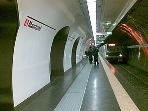
Manzoni – Museo della Liberazione (Rome Metro)
Rome metro station
Distance: Approx. 375 meters
Latitude and longitude: 41.89027778,12.50694444
Manzoni–Museo della Liberazione (formerly Manzoni) is an underground station on Line A of the Rome Metro, inaugurated in 1980. It is located under the junction of Viale Alessandro Manzoni, Via Emanuele Filiberto and Via San Quintino, in Esquilino rione.

Teatro Ambra Jovinelli
Theatre in Rome, Italy
Distance: Approx. 514 meters
Latitude and longitude: 41.8956,12.508
The Teatro Ambra Jovinelli (literally "Ambra Jovinelli Theater"), formerly known just as Teatro Jovinelli, is a theatre located in Rome, Italy. It was founded by the theater organizer Giuseppe Jovinelli, who intended to build a theater devoted to variety and comic representations which had a luxurious face and which appeared stylistically rich and noble. Built in the ancient Esquilino quarter, construction work began in 1906 and the inauguration took place in 1909.
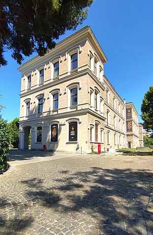
Museo nazionale degli strumenti musicali
Italian museum
Distance: Approx. 423 meters
Latitude and longitude: 41.8889,12.5147
The National Museum of Musical Instruments is situated in the Palazzina Samoggia in Rome. The museum, owned by the MIBACT since December 2014 is one of 43 museums pertaining to the Polo museale del Lazio. The museum had 9,164 visitors in 2015.

Porta Maggiore Basilica
Ancient religious monument in Rome, Italy
Distance: Approx. 335 meters
Latitude and longitude: 41.891512,12.515144
The Porta Maggiore Basilica is an underground basilica discovered in 1917 near Porta Maggiore in Rome. It is dated to the first century BC. It is believed to have been the meeting place of the neo-Pythagoreans, and is the only historical site that has been associated with the neo-Pythagorean movement. This school of mystical Hellenistic philosophy preached asceticism and was based on the works of Pythagoras and Plato.

Santa Maria Immacolata all'Esquilino
Church in Rome, Italy
Distance: Approx. 428 meters
Latitude and longitude: 41.891,12.506
Santa Maria Immacolata all'Esquilino is a 20th-century parochial church and titular church on the Esquiline Hill in Rome, dedicated to Mary Immaculate.
Weather in this IP's area
clear sky
24 Celsius
24 Celsius
22 Celsius
26 Celsius
1014 hPa
61 %
1014 hPa
1008 hPa
10000 meters
1.03 m/s
06:43:15
19:32:13