Country:
 Italy
ItalyRegion:
City:
Latitude and Longitude:
Time Zone:
Postal Code:
IP information under different IP Channel
ip-api
Country
Region
City
ASN
Time Zone
ISP
Blacklist
Proxy
Latitude
Longitude
Postal
Route
IPinfo
Country
Region
City
ASN
Time Zone
ISP
Blacklist
Proxy
Latitude
Longitude
Postal
Route
MaxMind
Country
Region
City
ASN
Time Zone
ISP
Blacklist
Proxy
Latitude
Longitude
Postal
Route
Luminati
Country
 NL
NLASN
Time Zone
Europe/Amsterdam
ISP
ATGS-MMD-AS
Latitude
Longitude
Postal
db-ip
Country
Region
City
ASN
Time Zone
ISP
Blacklist
Proxy
Latitude
Longitude
Postal
Route
ipdata
Country
Region
City
ASN
Time Zone
ISP
Blacklist
Proxy
Latitude
Longitude
Postal
Route
Popular places and events near this IP address

Cortenuova
Comune in Lombardy, Italy
Distance: Approx. 2654 meters
Latitude and longitude: 45.53333333,9.78333333
Cortenuova (also Cortenova; Bergamasque: Cor-nöa) is a town and comune in the province of Bergamo, Lombardy (northern Italy). The battle of Cortenuova was fought here in 1237.

Antegnate
Comune in Lombardy, Italy
Distance: Approx. 4730 meters
Latitude and longitude: 45.48333333,9.78333333
Antegnate (Bergamasque: Antegnàt) is a comune (municipality) in the Province of Bergamo in the Italian region of Lombardy, located about 50 kilometres (31 mi) east of Milan and about 25 kilometres (16 mi) southeast of Bergamo. Antegnate borders the following municipalities: Barbata, Calcio, Covo, Fontanella.

Bariano
Comune in Lombardy, Italy
Distance: Approx. 4272 meters
Latitude and longitude: 45.51666667,9.7
Bariano (Bergamasque: Barià) is a comune (municipality) in the Province of Bergamo in the Italian region of Lombardy, located about 40 kilometres (25 mi) east of Milan and about 20 kilometres (12 mi) south of Bergamo. Bariano borders the following municipalities: Caravaggio, Fara Olivana con Sola, Fornovo San Giovanni, Morengo, Pagazzano, Romano di Lombardia.

Covo
Comune in Lombardy, Italy
Distance: Approx. 2493 meters
Latitude and longitude: 45.5,9.76666667
Covo (Bergamasque: Cóf) is a comune (municipality) in the Province of Bergamo in the Italian region of Lombardy, located about 45 kilometres (28 mi) east of Milan and about 25 kilometres (16 mi) southeast of Bergamo. As of 31 December 2021, it had a population of 4,218 and an area of 12.7 square kilometres (4.9 sq mi). Covo borders the following municipalities : Antegnate, Barbata, Calcio, Cortenuova, Fara Olivana con Sola, Isso, Romano di Lombardia.

Fara Olivana con Sola
Comune in Lombardy, Italy
Distance: Approx. 2331 meters
Latitude and longitude: 45.5,9.75
Fara Olivana con Sola is a comune (municipality) in the Province of Bergamo in the Italian region of Lombardy, located about 45 kilometres (28 mi) east of Milan and about 25 kilometres (16 mi) southeast of Bergamo. Fara Olivana con Sola borders the following municipalities: Bariano, Castel Gabbiano, Covo, Fornovo San Giovanni, Isso, Mozzanica, Romano di Lombardia. It is formed by two main settlements: Fara Olivana on the north, set of the pieve of Santo Stefano, and the frazione Sola southwards.

Fornovo San Giovanni
Comune in Lombardy, Italy
Distance: Approx. 6009 meters
Latitude and longitude: 45.5,9.68333333
Fornovo San Giovanni (Bergamasque: Fùrnof) is a comune (municipality) in the Province of Bergamo in the Italian region of Lombardy, located in the Gera d'Adda, about 40 kilometres (25 mi) east of Milan and about 20 kilometres (12 mi) south of Bergamo. Fornovo San Giovanni borders the following municipalities: Bariano, Caravaggio, Fara Olivana con Sola, Mozzanica, Romano di Lombardia.

Isso, Lombardy
Comune in Lombardy, Italy
Distance: Approx. 4267 meters
Latitude and longitude: 45.48333333,9.76666667
Isso (Bergamasque: Iss) is a comune (municipality) in the Province of Bergamo in the Italian region of Lombardy, located about 45 kilometres (28 mi) east of Milan and about 25 kilometres (16 mi) southeast of Bergamo. Isso borders the following municipalities: Barbata, Camisano, Castel Gabbiano, Covo, Fara Olivana con Sola.

Martinengo (Italy)
Comune in Lombardy, Italy
Distance: Approx. 5205 meters
Latitude and longitude: 45.56666667,9.76666667
Martinengo (Bergamasque: Martinèngh) is a comune (municipality) in the Province of Bergamo in the Italian region of Lombardy, located about 50 kilometres (31 mi) east of Milan and about 15 kilometres (9 mi) southeast of Bergamo. As of 31 December 2004, it had a population of 9,138 and an area of 21.7 square kilometres (8.4 sq mi). The municipality of Martinengo contains the frazione (subdivision) Cortenuova di Sopra.

Morengo
Comune in Lombardy, Italy
Distance: Approx. 4475 meters
Latitude and longitude: 45.53333333,9.7
Morengo (Bergamasque: Morèngh) is a comune (municipality) in the Province of Bergamo in the Italian region of Lombardy, located about 40 kilometres (25 mi) east of Milan and about 20 kilometres (12 mi) south of Bergamo. Morengo borders the following municipalities: Bariano, Brignano Gera d'Adda, Caravaggio, Cologno al Serio, Martinengo, Pagazzano, Romano di Lombardia.
Romano railway station
Distance: Approx. 415 meters
Latitude and longitude: 45.52388889,9.75722222
Romano (Italian: Stazione di Romano) is a railway station serving the town of Romano di Lombardia, in the region of Lombardy, northern Italy. The station is located on the Milan–Venice railway. The train services are operated by Trenord.

Morengo-Bariano railway station
Distance: Approx. 4011 meters
Latitude and longitude: 45.52138889,9.70305556
Morengo-Bariano (Italian: Stazione di Morengo-Bariano) is a railway station serving the towns of Morengo and Bariano, in the region of Lombardy, northern Italy. The station is located on the Milan–Venice railway. The train services are operated by Trenord.
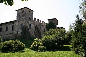
Visconti Rocca (Romano di Lombardia)
Castle in northern Italy
Distance: Approx. 100 meters
Latitude and longitude: 45.52111111,9.75333333
The Visconti Rocca of Romano is a rocca in Romano di Lombardia, Bergamo, Lombardy in Northern Italy. It was built in the 13th century and expanded in the 14th and 15th centuries by the Visconti and Colleoni families.
Weather in this IP's area
scattered clouds
21 Celsius
22 Celsius
21 Celsius
23 Celsius
1014 hPa
83 %
1014 hPa
1000 hPa
10000 meters
2.06 m/s
360 degree
40 %
06:51:17
19:46:13