Country:
 Italy
ItalyRegion:
City:
Latitude and Longitude:
Time Zone:
Postal Code:
IP information under different IP Channel
ip-api
Country
Region
City
ASN
Time Zone
ISP
Blacklist
Proxy
Latitude
Longitude
Postal
Route
IPinfo
Country
Region
City
ASN
Time Zone
ISP
Blacklist
Proxy
Latitude
Longitude
Postal
Route
MaxMind
Country
Region
City
ASN
Time Zone
ISP
Blacklist
Proxy
Latitude
Longitude
Postal
Route
Luminati
Country
 NL
NLASN
Time Zone
Europe/Amsterdam
ISP
ATGS-MMD-AS
Latitude
Longitude
Postal
db-ip
Country
Region
City
ASN
Time Zone
ISP
Blacklist
Proxy
Latitude
Longitude
Postal
Route
ipdata
Country
Region
City
ASN
Time Zone
ISP
Blacklist
Proxy
Latitude
Longitude
Postal
Route
Popular places and events near this IP address

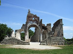
Second Battle of the Piave River
World War I battle won by Italy
Distance: Approx. 6168 meters
Latitude and longitude: 45.83055556,12.20944444
The Second Battle of the Piave River (or Battle of the Solstice), fought between 15 and 23 June 1918, was a decisive victory for the Italian Army against the Austro-Hungarian Empire during World War I, as Italy was part of the Allied Forces, while Austria-Hungary was part of the Central Powers. Though the battle proved to be a decisive blow to the Austro-Hungarian Empire and by extension the Central Powers, its full significance was not initially appreciated in Italy. Yet Erich Ludendorff, on hearing the news, is reported to have said he 'had the sensation of defeat for the first time'.

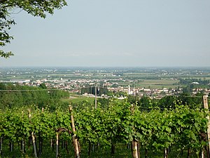
Conegliano
Comune in Veneto, Italy
Distance: Approx. 4864 meters
Latitude and longitude: 45.88675556,12.29738889
Conegliano (Italian: [koneʎˈʎaːno]; Venetian: Conejan) is a town and comune of the Veneto region, Italy, in the province of Treviso, about 30 kilometres (19 mi) north by rail from the town of Treviso. The population of the city is of 35,023 people. The remains of a 10th-century castle are situated on a hill that dominates the town.

Santa Lucia di Piave
Comune in Veneto, Italy
Distance: Approx. 748 meters
Latitude and longitude: 45.85,12.28333333
Santa Lucia di Piave is a comune in the province of Treviso, Veneto, north-eastern Italy.

Mareno di Piave
Comune in Veneto, Italy
Distance: Approx. 4958 meters
Latitude and longitude: 45.85,12.35
Mareno di Piave is a comune (municipality) in the Province of Treviso in the Italian region Veneto, located about 45 kilometres (28 mi) north of Venice and about 20 kilometres (12 mi) northeast of Treviso. Mareno di Piave borders the following municipalities: Cimadolmo, Codogné, Conegliano, San Vendemiano, Santa Lucia di Piave, Spresiano, Vazzola.
Nervesa della Battaglia
Comune in Veneto, Italy
Distance: Approx. 5553 meters
Latitude and longitude: 45.83333333,12.21666667
Nervesa della Battaglia is a comune (municipality) in the Province of Treviso in the Italian region Veneto, located about 45 kilometres (28 mi) north of Venice and about 20 kilometres (12 mi) north of Treviso. In February 1358 Nervesa was the scene of a battle in which the Republic of Venice was defeated by the forces of King Louis I of Hungary. That defeat forced the Venetians to sign the highly unfavorable Treaty of Zadar.
Spresiano
Comune in Veneto, Italy
Distance: Approx. 7298 meters
Latitude and longitude: 45.78333333,12.25
Spresiano is a comune (municipality) in the Province of Treviso in the Italian region Veneto, located about 40 kilometres (25 mi) north of Venice and about 13 kilometres (8 mi) north of Treviso. As of 31 December 2004, it had a population of 10,155 and an area of 25.6 square kilometres (9.9 sq mi). The municipality of Spresiano contains the frazioni (subdivisions, mainly villages and hamlets) Spresiano, Lovadina and Visnadello.
Susegana
Comune in Veneto, Italy
Distance: Approx. 2931 meters
Latitude and longitude: 45.85,12.25
Susegana is a comune (municipality) in the Province of Treviso in the Italian region Veneto, located about 45 km (28 mi) north of Venice and about 20 km (12 mi) north of Treviso.

Vazzola
Comune in Veneto, Italy
Distance: Approx. 7583 meters
Latitude and longitude: 45.83333333,12.38333333
Vazzola is a comune (municipality) in the Province of Treviso in the Italian region Veneto, located about 45 kilometres (28 mi) north of Venice and about 20 kilometres (12 mi) northeast of Treviso. Vazzola borders the following municipalities: Cimadolmo, Codogné, Fontanelle, Mareno di Piave, San Polo di Piave.
Bavaria, Nervesa della Battaglia
Distance: Approx. 8734 meters
Latitude and longitude: 45.80694444,12.18722222
Bavaria is a ward of the municipality of Nervesa della Battaglia in Treviso province. The village has 1280 residents, is located 78 m asl and its inhabitants are called Bavariani.

Conegliano railway station
Railway station in Veneto, Italy
Distance: Approx. 4659 meters
Latitude and longitude: 45.88472222,12.29861111
Conegliano (Italian: Stazione di Conegliano) is a railway station serving the town of Conegliano, in the region of Veneto, northern Italy. The station opened on 1 May 1855 and is located on the Venice–Udine railway and Ponte nelle Alpi-Conegliano railway. The train services are operated by Trenitalia.

Collalto, Susegana
Village in Treviso, Italy
Distance: Approx. 7536 meters
Latitude and longitude: 45.8717,12.1982
Collalto is a village in the province of Treviso in northern Italy, forming a 'frazione' or part of the municipality of Susegana.
Soligo (river)
River in Italy
Distance: Approx. 7891 meters
Latitude and longitude: 45.8529,12.1858
The Soligo is a river in the Province of Treviso in Italy. It is supplied by the artificial canal known as the Tajada, flowing out of the lakes of Revine Lago, known as Lago and Santa Maria - the stretch of the canal after the village of Soller is known as the Soligo. It flows west along the Valmareno, before turning south at Follina and finally flowing into the Piave to the south-east of Falzè di Piave.
Weather in this IP's area
light rain
16 Celsius
16 Celsius
15 Celsius
17 Celsius
1016 hPa
89 %
1016 hPa
1010 hPa
3484 meters
4.12 m/s
6.89 m/s
60 degree
100 %
07:31:41
18:19:53