195.183.141.119 - IP Lookup: Free IP Address Lookup, Postal Code Lookup, IP Location Lookup, IP ASN, Public IP
Country:
 Spain
SpainRegion:
City:
Location:
Time Zone:
Postal Code:
ISP:
ASN:
language:
User-Agent:
Proxy IP:
Blacklist:
IP information under different IP Channel
ip-api
Country
Region
City
ASN
Time Zone
ISP
Blacklist
Proxy
Latitude
Longitude
Postal
Route
db-ip
Country
Region
City
ASN
Time Zone
ISP
Blacklist
Proxy
Latitude
Longitude
Postal
Route
IPinfo
Country
Region
City
ASN
Time Zone
ISP
Blacklist
Proxy
Latitude
Longitude
Postal
Route
IP2Location
195.183.141.119Country
esRegion
madrid, comunidad de
City
tres cantos
Time Zone
Europe/Madrid
ISP
Language
User-Agent
Latitude
Longitude
Postal
ipdata
Country
Region
City
ASN
Time Zone
ISP
Blacklist
Proxy
Latitude
Longitude
Postal
Route
Popular places and events near this IP address
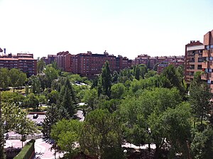
Tres Cantos
Municipality in Community of Madrid, Spain
Distance: Approx. 342 meters
Latitude and longitude: 40.59944444,-3.71166667
Tres Cantos (Spanish: [tɾes ˈkantos] ) is a municipality of Spain located in Community of Madrid. Originally belonging to Colmenar Viejo, it seceded from the latter municipality in 1991, becoming the youngest municipality in the region. The urbanised area was conceived as a "satellite city" of Madrid developed by urban planners in the 1970s.

Autonomous University of Madrid
Spanish public university in Madrid
Distance: Approx. 6272 meters
Latitude and longitude: 40.5453,-3.69611
The Autonomous University of Madrid (Spanish: Universidad Autónoma de Madrid; UAM), commonly known as la Autónoma, is a Spanish public university located in Madrid, Spain. The university was founded in 1968 by royal decree. UAM is widely respected as one of the most prestigious universities in Europe.

Padre Manyanet School, Alcobendas, Madrid
School in Alcobendas, Spain
Distance: Approx. 6023 meters
Latitude and longitude: 40.55248889,-3.67628889
Padre Manyanet School [2] in Alcobendas (Madrid, Spain) began life on 27 September 1980. In 1990 there was an enlargement, so that pupils could study in the school until the very last year before university. It is a religious school of the Congregation of Sons and Daughters of the Holy Family for pupils aged three to eighteen.

Soto de Viñuelas
Distance: Approx. 2004 meters
Latitude and longitude: 40.6102,-3.6878
Soto de Viñuelas is a meadow-oak forest north of the city of Madrid, south of Tres Cantos and San Agustín del Guadalix, east of the Monte de El Pardo and west of San Sebastián de los Reyes, all municipalities are parts of the Community of Madrid, Spain. Much of it is a fenced property of 3,000 hectares, which includes important ecological values, landscape and art. It belongs to the municipality of Madrid, although it contains small areas to the north, corresponding to Tres Cantos, including a development of the same name (i.e., Soto de Viñuelas).

Torre de la Parada
Distance: Approx. 7418 meters
Latitude and longitude: 40.54472222,-3.75527778
The Torre de la Parada is a former hunting lodge that was located in present-day Monte de El Pardo in Fuencarral-El Pardo, near the Royal Palace of El Pardo, some way outside Madrid in the Sierra de Guadarrama. It was mostly destroyed by fire when taken in 1714 by Austrian troops in the War of Spanish Succession, though the ruins remain.
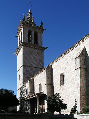
Basilica of la Asunción de Nuestra Señora (Colmenar Viejo)
Historic site in Colmenar Viejo, Spain
Distance: Approx. 8020 meters
Latitude and longitude: 40.657741,-3.766428
The Basilica of la Asunción de Nuestra Señora (Spanish: Basílica de la Asunción de Nuestra Señora) is a gothic basilica located in Colmenar Viejo, Spain. It was declared Bien de Interés Cultural in 1997.

Institute of Mathematical Sciences (Spain)
Research institute affiliated to the CSIC, Spain's Superior Council of Scientific Research
Distance: Approx. 6002 meters
Latitude and longitude: 40.5494,-3.6871
The Institute of Mathematical Sciences (Spanish: Instituto de Ciencias Matemáticas – ICMAT) is a mixed institute affiliated to the Spanish National Research Council (CSIC) in partnership with three public universities: the Autonomous University of Madrid (UAM), the Charles III University of Madrid (UC3M) and the Complutense University of Madrid (UCM). Founded in 2010, the ICMAT headquarters is located in the Cantoblanco Campus in Northern Madrid. The ICMAT is composed of the mathematicians belonging to the CSIC and researchers from the three Madrid universities.

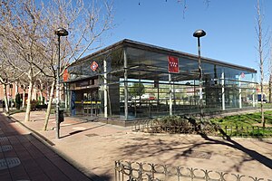
Marqués de la Valdavia (Madrid Metro)
Madrid Metro station
Distance: Approx. 8954 meters
Latitude and longitude: 40.5410236,-3.6373849
Marqués de la Valdavia [maɾˈkes ðe la βalˈdaβja] is a station on Line 10 of the Madrid Metro, near the Calle del Marqués de la Valdavia, which was named for the politician Mariano Ossorio Arévalo, 3rd Marquess of Valdivia (1889–1969). It is located in fare Zone B1.

Manuel de Falla (Madrid Metro)
Madrid Metro station
Distance: Approx. 7635 meters
Latitude and longitude: 40.5504843,-3.6468756
Manuel de Falla [maˈnwel de ˈfaʎa] is a station on Line 10 of the Madrid Metro, on the calle de Manuel de Falla, named for the composer and pianist Manuel de Falla (1876–1946). It is located in fare Zone B1.

Baunatal (Madrid Metro)
Madrid Metro station
Distance: Approx. 8059 meters
Latitude and longitude: 40.554395,-3.6350471
Baunatal [bawnaˈtal] is a station on Line 10 of the Madrid Metro. It is located in fare Zone B1. The station was named after the Avenida de Baunatal, which in turn got its name from the Hessian town of Baunatal, a sister city of San Sebastián de los Reyes since 1990.
Reyes Católicos (Madrid Metro)
Madrid Metro station
Distance: Approx. 9106 meters
Latitude and longitude: 40.5503789,-3.6233956
Reyes Católicos [ˈreʝes kaˈtolikos] is a station on Line 10 of the Madrid Metro, naemd for the nearby Avenida de los Reyes Católicos ("Avenue of the Catholic Monarchs"). It is located in fare Zone B1.

El Goloso
City neighborhood in Madrid, Community of Madrid, Spain
Distance: Approx. 5002 meters
Latitude and longitude: 40.55611111,-3.70333333
El Goloso is an administrative neighborhood (barrio) of Madrid belonging to the district of Fuencarral-El Pardo. On August 20, 1943, the Armoured Division No. 1 "Brunete" was established at the El Goloso Camp under the command of Major-General Ricardo Rada Peral.
Weather in this IP's area
clear sky
13 Celsius
11 Celsius
12 Celsius
14 Celsius
1031 hPa
38 %
1031 hPa
941 hPa
10000 meters
0.51 m/s
80 degree