Country:
Region:
City:
Latitude and Longitude:
Time Zone:
Postal Code:
IP information under different IP Channel
ip-api
Country
Region
City
ASN
Time Zone
ISP
Blacklist
Proxy
Latitude
Longitude
Postal
Route
Luminati
Country
ASN
Time Zone
Europe/Rome
ISP
Mynet S.r.l.
Latitude
Longitude
Postal
IPinfo
Country
Region
City
ASN
Time Zone
ISP
Blacklist
Proxy
Latitude
Longitude
Postal
Route
db-ip
Country
Region
City
ASN
Time Zone
ISP
Blacklist
Proxy
Latitude
Longitude
Postal
Route
ipdata
Country
Region
City
ASN
Time Zone
ISP
Blacklist
Proxy
Latitude
Longitude
Postal
Route
Popular places and events near this IP address

University of Trento
Public university in Trento, Italy
Distance: Approx. 2606 meters
Latitude and longitude: 46.0694,11.1211
The University of Trento (Italian: Università degli Studi di Trento) is an Italian university located in Trento and nearby Rovereto. It has been able to achieve considerable results in didactics, research, and international relations according to CENSIS (Centro Studi Investimenti Sociali) and the Italian Ministry of Education.

Prince-Bishopric of Trent
Imperial estate of the Holy Roman Empire in present-day northern Italy (1027-1803)
Distance: Approx. 2829 meters
Latitude and longitude: 46.0674,11.1214
The Prince-Bishopric of Trent (Latin: Episcopatus ac Principatus Tridentinus; German: Hochstift Trient, Fürstbistum Trient, Bistum Trient) was an ecclesiastical principality roughly corresponding to the present-day Northern Italian autonomous province of Trentino. It was created in 1027 and existed until 1803, when it was secularised and absorbed into the County of Tyrol held by the House of Habsburg. Trent was a Hochstift, an Imperial State under the authority of a prince-bishop at Trento.

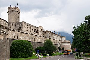
Buonconsiglio Castle
Distance: Approx. 2469 meters
Latitude and longitude: 46.0711,11.1269
Buonconsiglio Castle (Italian: Castello del Buonconsiglio) is a castle in Trento, northern Italy.

Trento Cathedral
Church in Trento, Italy
Distance: Approx. 2874 meters
Latitude and longitude: 46.067,11.1216
Trento Cathedral (Italian: Cattedrale di San Vigilio, Duomo di Trento; German: Kathedrale Trient) is a Roman Catholic cathedral in Trento, northern Italy. It is the mother church of the Roman Catholic Archdiocese of Trento, and until 1802, was the seat of the Prince-Bishopric of Trent. It was built over a pre-existing 4th-century church devoted to Saint Vigilius (Italian: San Vigilio), patron saint of the city.

Cognola
Distance: Approx. 2476 meters
Latitude and longitude: 46.07638889,11.14194444
Cognola is a town in the Trentino province, Italy. Administratively it counts as one of the frazioni of the comune (municipality) of Trento, the third town of the Alps when it comes to population. It has a population of about 5,000 inhabitants.

Roman Catholic Archdiocese of Trento
Roman Catholic archdiocese in Italy
Distance: Approx. 2919 meters
Latitude and longitude: 46.0667,11.1167
The Archdiocese of Trento (Latin: Archidioecesis Tridentina, German Trient) is a Latin Metropolitan archdiocese of the Catholic Church in the Triveneto, named after its see in Alpine Italy, Trento (Tr(i)ent), in Trentino-Alto Adige region. The seat (throne) of the archbishop is in the Minor basilica Cattedrale di S. Vigilio Vescovo in Trento. The diocese has two other minor basilicas: the Basilica S. Maria Maggiore (city of Trento), and the Basilica di Ss.

Etschtal
Alpine valley region in Italy
Distance: Approx. 2538 meters
Latitude and longitude: 46.07,11.12
The Etschtal, Italian: Val d'Adige or Valle dell'Adige, is the name given to a part of alpine valley of the Adige in Trentino-Alto Adige, Italy, which stretches from Merano to Bolzano and from Salorno to Rovereto. South of Rovereto, the valley's name changes to Vallagarina, but Val d'Adige is often used to define the whole river valley, up to its entrance into the Padan Plain. The valley separates: at the top, the Alps (to the West) from the Dolomites (to the East); at the bottom the Pre-Alps and Lake Garda (to the West) from the Venetian pre-Alps (to the East).

Giro al Sas
Distance: Approx. 2787 meters
Latitude and longitude: 46.06777778,11.12138889
The Giro al Sas, also known as the Giro Podistico di Trento and the Giro Internazionale Città di Trento, is an annual 10-kilometre road running competition for men which takes place in October in the city of Trento, Italy. First held as a part of celebrations for Saint Vigilius of Trent in 1907, the competition was interrupted by World Wars but has been held virtually every year since 1945. This makes it one of Europe's longest-running competitions of its type.

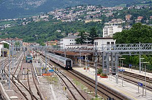
Trento railway station
Railway station in Italy
Distance: Approx. 2323 meters
Latitude and longitude: 46.07194444,11.11944444
Trento railway station (Italian: Stazione Ferroviaria di Trento, German: Bahnhof Trient) is the main station of Trento, capital of the autonomous province of Trentino, in northeastern Italy. The station was opened in 1859 by the Austrian Empire's Südbahn. It is located on the trans-Alpine Brenner Railway connecting Verona to Innsbruck.
Busa del Pomar
Distance: Approx. 2892 meters
Latitude and longitude: 46.1183985,11.1267016
'Busa del Pomar' is an ancient silver mine located in the north of Italy, just north east Trento. It is one of the major mines (locally called canope) that are part of the old Monte Calisio silver-mining complex.
Monte Calisio
Mountain in Italy
Distance: Approx. 1891 meters
Latitude and longitude: 46.097757,11.143727
Monte Calisio (also called Argentario from Argento, meaning silver in Italian), at 3,582 feet (1,092 m), is a mountain located in the North of Italy and surrounded by the suburbs of Trento and Civezzano: Martignano, Cognola, Villamontagna, Gardolo and Melta di Gardolo.

Santa Maria Maggiore, Trento
Church building in Italy
Distance: Approx. 2695 meters
Latitude and longitude: 46.0686,11.1194
The Church of Santa Maria Maggiore is an important place of worship in the city of Trento, and the site of the Third Session of the Council of Trent. It was built by Antonio Medaglia on the model of the basilica of Sant'Andrea in Mantua, at the wish of the Prince-Archbishop Bernardo Clesio. In November 1973 Pope Paul VI accorded it the status of minor cathedral.
Weather in this IP's area
clear sky
4 Celsius
4 Celsius
2 Celsius
4 Celsius
1025 hPa
34 %
1025 hPa
1000 hPa
10000 meters
1.19 m/s
1.36 m/s
11 degree
07:16:41
16:43:53