Country:
Region:
City:
Latitude and Longitude:
Time Zone:
Postal Code:
IP information under different IP Channel
ip-api
Country
Region
City
ASN
Time Zone
ISP
Blacklist
Proxy
Latitude
Longitude
Postal
Route
Luminati
Country
Region
03
City
oslo
ASN
Time Zone
Europe/Oslo
ISP
Globalconnect As
Latitude
Longitude
Postal
IPinfo
Country
Region
City
ASN
Time Zone
ISP
Blacklist
Proxy
Latitude
Longitude
Postal
Route
db-ip
Country
Region
City
ASN
Time Zone
ISP
Blacklist
Proxy
Latitude
Longitude
Postal
Route
ipdata
Country
Region
City
ASN
Time Zone
ISP
Blacklist
Proxy
Latitude
Longitude
Postal
Route
Popular places and events near this IP address
Røa
Neighbourhood in Oslo, Norway
Distance: Approx. 1683 meters
Latitude and longitude: 59.95,10.65
Røa (Norwegian pronunciation: [ˈrø̀ːɑ]) is a neighbourhood and a former administrative borough of the city of Oslo, Norway. In 2004 the borough of Røa was merged with neighbouring Vinderen to become Vestre Aker borough. Røa is a suburb of Oslo, located approximately 7 kilometers away from downtown Oslo.

Ekraveien (station)
Oslo metro station
Distance: Approx. 942 meters
Latitude and longitude: 59.95027778,10.63666667
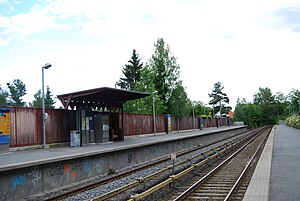
Ekraveien is the last Oslo Metro station on the Røa Line within Oslo's city limits. It is between the stations Røa and Eiksmarka. It was opened 22 December 1948 when the Røa Line was extended to Grini.

Østerås station
Oslo metro station
Distance: Approx. 1527 meters
Latitude and longitude: 59.93916667,10.60888889
Østerås is the terminal station on the Røa Line of the Oslo Metro. The station is located in Bærum municipality, 10.2 km from Stortinget and was opened on 16 November 1972, extending the line from Lijordet. Østerås is a largely residential area.
Røa (station)
Oslo metro station
Distance: Approx. 1445 meters
Latitude and longitude: 59.94666667,10.64388889
Røa is a station on Røa Line (Line 2) of the Oslo Metro, located in the Vestre Aker borough, 7.5 kilometers (4.7 mi) from Stortinget. The station is located between the stations of Hovseter and Ekraveien. The station is part of the old western suburban rail network and was opened on 24 January 1935, slightly to the west of the current location.

Eiksmarka (station)
Oslo metro station
Distance: Approx. 574 meters
Latitude and longitude: 59.94666667,10.62222222
Eiksmarka is a station on the Røa Line of the Oslo Metro. It is located between Ekraveien and Lijordet, 8.9 km from Stortinget. The station was opened in 1951 as part of the extension to Lijordet.
Lijordet (station)
Oslo metro station
Distance: Approx. 1226 meters
Latitude and longitude: 59.94083333,10.61638889
Lijordet is a station on the Røa Line of the Oslo Metro. It is located between Østerås and Eiksmarka, 9.6 km from Stortinget. It is the second of three stations on the Røa Line within Bærum municipality.

Eiksmarka
Village in Østlandet, Norway
Distance: Approx. 574 meters
Latitude and longitude: 59.94666667,10.62222222
Eiksmarka ("Oakfield") is an affluent suburb of the Norwegian municipality of Bærum in the Greater Oslo Region with around 4,000 inhabitants. It is located just west of the border of Oslo municipality, but within the contiguous urban area of Oslo as well as within the Diocese of Oslo. It is served by Eiksmarka station of the Oslo Metro as well as bus lines.
Grini (station)
Former Oslo metro station
Distance: Approx. 618 meters
Latitude and longitude: 59.9494,10.6301
Grini is a former metro station on the Røa Line of the Oslo Metro. The station was located between Ekraveien and Eiksmarka, and was opened when the Røa Line was extended into Bærum on 22 December 1948. It was the first station on the Røa Line located in Bærum; the line would later be extended to Lijordet (1951) and Østerås (1972).

Øvrevoll Galoppbane
Distance: Approx. 1366 meters
Latitude and longitude: 59.9395,10.6227
Øvrevoll Galoppbane is the only gallop racecourse in Norway It is located at Øvrevoll between Østerås (west), Jar (south) and Eiksmarka (north) in Bærum. It has both a turf track and an all-weather track. It was officially opened in 1932 by King Haakon VII and Queen Maud.

Grini
District in northeastern Bærum, Norway
Distance: Approx. 634 meters
Latitude and longitude: 59.9494,10.6304
Grini is a district in northeastern Bærum, Norway.

Østerås
Village in Østlandet, Norway
Distance: Approx. 1290 meters
Latitude and longitude: 59.94194444,10.6075
Østerås is a village in Akershus, Norway. Østerås (station) the west end station of the Oslo Metro line 2, which is also known as the Østerås metro line.

Røa Church
Church in Oslo, Norway
Distance: Approx. 1319 meters
Latitude and longitude: 59.94972222,10.64333333
Røa Church (Norwegian: Røa kirke) is a church center in Oslo, Norway. The church room has 300 seats, but this can be increased to 500 by opening the sliding doors to the parish hall. The church building also includes offices, a wing of verger housing and daycare.
Weather in this IP's area
overcast clouds
0 Celsius
0 Celsius
-2 Celsius
2 Celsius
1018 hPa
85 %
1018 hPa
999 hPa
10000 meters
1.05 m/s
1.02 m/s
261 degree
99 %
08:13:25
15:50:47


