Country:
 Austria
Region:
City:
Latitude and Longitude:
Time Zone:
Postal Code:
IP information under different IP Channel
ip-api
Country
Region
City
ASN
Time Zone
ISP
Blacklist
Proxy
Latitude
Longitude
Postal
Route
IPinfo
Country
Region
City
ASN
Time Zone
ISP
Blacklist
Proxy
Latitude
Longitude
Postal
Route
MaxMind
Country
Region
City
ASN
Time Zone
ISP
Blacklist
Proxy
Latitude
Longitude
Postal
Route
Luminati
Country
ATRegion
7
City
hallintirol
ASN
Time Zone
Europe/Vienna
ISP
HALLAG Kommunal GmbH
Latitude
Longitude
Postal
db-ip
Country
Region
City
ASN
Time Zone
ISP
Blacklist
Proxy
Latitude
Longitude
Postal
Route
ipdata
Country
Region
City
ASN
Time Zone
ISP
Blacklist
Proxy
Latitude
Longitude
Postal
Route
Popular places and events near this IP address

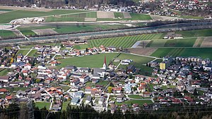
Hall in Tirol
Place in Tyrol, Austria
Distance: Approx. 1539 meters
Latitude and longitude: 47.28333333,11.5
Hall in Tirol is a town in the Innsbruck-Land district of Tyrol, Austria. Located at an altitude of 574 m, about 5 km (3 mi) east of the state's capital Innsbruck in the Inn valley, it has a population of 14,771 (Dec 2023).

Judenstein
District
Distance: Approx. 2035 meters
Latitude and longitude: 47.2603,11.5056
Judenstein ("Jew stone") is a district of the village of Rinn, Austria, in the state of Tyrol. In 1671, the blood libel cult of Anderl von Rinn emerged, and a church was built around a rock where a child (Anderl, "Little Andrew") had allegedly been killed by Jews in a ritual murder, hence the place name. There is a large stone within the nave of the church which was probably brought in from elsewhere, since there are no other large freestanding stones in the immediate neighbourhood, although there were at the time when the church was built.

Absam
Place in Tyrol, Austria
Distance: Approx. 1539 meters
Latitude and longitude: 47.28333333,11.5
Absam is a municipality in the Innsbruck-Land District, Tyrol (Austria) situated at an altitude of 632 m, which had an area of 51.92 km2 and 6,776 inhabitants as January 2015.

Weißenbach (Inn)
River in Tyrol, Austria
Distance: Approx. 824 meters
Latitude and longitude: 47.2786,11.5283
The Weißenbach is a river of Tyrol, Austria, a tributary of the Inn. The Weißenbach rises in the valley Halltal and flows near Absam from Gnadenwald to the south to the village of Mils, which is located 12 km (7.5 mi) east of Innsbruck. In Mils just after the Lower Inn Valley Railway bridge it discharges into the Inn.

Baumkirchen
Place in Tyrol, Austria
Distance: Approx. 3541 meters
Latitude and longitude: 47.29972222,11.55
Baumkirchen is a community in the district of Innsbruck Land. It lies in the Inn Valley north of the Inn River on a batter of the Gnadenwald terrace. The village can be reached via the Inn Valley Motorway.
Volders
Place in Tyrol, Austria
Distance: Approx. 3785 meters
Latitude and longitude: 47.2875,11.56527778
Volders is a municipality in the district of Innsbruck-Land in the Austrian state of Tyrol located 12 km east of Innsbruck on the southern side of the Inn River.

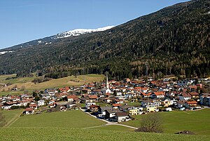
Tulfes
Place in Tyrol, Austria
Distance: Approx. 2382 meters
Latitude and longitude: 47.25694444,11.53027778
Tulfes is a municipality in the district of Innsbruck-Land in the Austrian state of Tyrol, located 12 km east of Innsbruck and 6 km above Hall in Tirol. The village was mentioned as “Tellevo” for the first time in 1240. Main source of income is tourism.

Thaur
Place in Tyrol, Austria
Distance: Approx. 4023 meters
Latitude and longitude: 47.295,11.47194444
Thaur is a municipality in the district of Innsbruck-Land in the Austrian state of Tyrol located 5 km east of Innsbruck between Rum, Austria and Hall in Tirol. Settlement of the area probably began around 1000 BC but the location was mentioned as “Taurane” for the first time in 827 when the Innichen Abbey acquired land. Thaur is very religious even nowadays.
Rinn
Place in Tyrol, Austria
Distance: Approx. 3207 meters
Latitude and longitude: 47.24944444,11.50361111
Rinn is a municipality in the district of Innsbruck-Land in the Austrian state of Tyrol located 6 km southeast of Innsbruck. The village was mentioned in documents as “Runne” in 1250 for the first time.

Mils, Tyrol
Place in Tyrol, Austria
Distance: Approx. 1279 meters
Latitude and longitude: 47.28638889,11.52666667
Mils is a municipality in the district Innsbruck-Land of Tyrol, Austria. It is located 12 km east of Innsbruck. The area is restricted by the Weißenbach in the west and the Inn in the south.

Innsbruck bypass
Key rail transport link in western Austria
Distance: Approx. 1878 meters
Latitude and longitude: 47.28194444,11.54138889
The Innsbruck bypass (German: Umfahrung Innsbruck or sometimes Güterzugumfahrung Innsbruck, that is the Innsbruck freight railway bypass) is a 14.853-kilometre (9.229 mi)-long double-track electrified main line of the Austrian railways. It connects the Lower Inn Valley railway with the Brenner railway, bypassing Innsbruck. It was opened on 29 May 1994.

UMIT Tirol - Private University for Health Sciences and Health Technology
Private Austrian university
Distance: Approx. 779 meters
Latitude and longitude: 47.2836,11.5176
UMIT Tirol - Private University for Health Sciences and Health Technology sees itself as a health university and is located in Hall in Tirol. It was founded in 2001 in Innsbruck under the name Private University of Medical Computer Science and Technology Tirol. In connection with the expansion of the health sciences in 2004, the university was re-named UMIT – Private University for Health Sciences, Medical Informatics and Technology.
Weather in this IP's area
mist
10 Celsius
10 Celsius
9 Celsius
13 Celsius
1022 hPa
94 %
1022 hPa
952 hPa
1400 meters
0.51 m/s
75 %
07:32:26
18:26:30