195.146.0.9 - IP Lookup: Free IP Address Lookup, Postal Code Lookup, IP Location Lookup, IP ASN, Public IP
Country:
Region:
City:
Location:
Time Zone:
Postal Code:
ISP:
ASN:
language:
User-Agent:
Proxy IP:
Blacklist:
IP information under different IP Channel
ip-api
Country
Region
City
ASN
Time Zone
ISP
Blacklist
Proxy
Latitude
Longitude
Postal
Route
db-ip
Country
Region
City
ASN
Time Zone
ISP
Blacklist
Proxy
Latitude
Longitude
Postal
Route
IPinfo
Country
Region
City
ASN
Time Zone
ISP
Blacklist
Proxy
Latitude
Longitude
Postal
Route
IP2Location
195.146.0.9Country
Region
bratislavsky kraj
City
bratislava
Time Zone
Europe/Bratislava
ISP
Language
User-Agent
Latitude
Longitude
Postal
ipdata
Country
Region
City
ASN
Time Zone
ISP
Blacklist
Proxy
Latitude
Longitude
Postal
Route
Popular places and events near this IP address
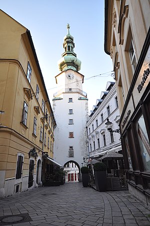
Michael's Gate
City gate from medieval fortifications in Bratislava, Slovakia
Distance: Approx. 341 meters
Latitude and longitude: 48.14514722,17.10666667
In Bratislava, Slovakia, Michael's Gate (Slovak: Michalská brána, German: Michaelertor, Hungarian: Mihály kapu) is the only city gate that has been preserved of the medieval fortifications and ranks among the oldest town buildings. Built about the year 1300, its present shape is the result of baroque reconstructions in 1758, when the statue of St. Michael and the Dragon was placed on its top.

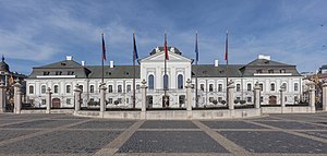
Grassalkovich Palace
Residence of the president of Slovakia in Bratislava
Distance: Approx. 128 meters
Latitude and longitude: 48.14924,17.10775
The Grassalkovich Palace (Slovak: Grasalkovičov palác, Hungarian: Grassalkovich-kastély) is a palace in Bratislava, Slovakia, and the residence of the President of Slovakia. It is situated on Hodžovo Square, near the Episcopal Summer Palace. The building is a Rococo (Late Baroque) summer palace with a French garden.

Bratislava 1
District in Bratislava Region, Slovakia
Distance: Approx. 381 meters
Latitude and longitude: 48.1486,17.1019
Bratislava I (Slovak: okres Bratislava I; Hungarian: Pozsonyi I. járás) is a district in the city of Bratislava. It is identical with its sole borough, Bratislava's Old Town (Slovak: Staré mesto; German: Altstadt; Hungarian: Óváros). With an area of 10 square kilometers, it is the smallest district of Slovakia.

Franciscan Church, Bratislava
Distance: Approx. 370 meters
Latitude and longitude: 48.145,17.10833333
The Franciscan Church (Slovak: Františkánsky kostol or Kostol Zvestovania Pána) is the oldest existing religious (sacral) building in the Old Town of Bratislava, the capital of Slovakia. The church was consecrated in the year 1297 in the presence of King Andrew III of Hungary. In the past, the church building served for larger gatherings of townspeople or Hungarian nobles.

Bratislava City Gallery
Distance: Approx. 386 meters
Latitude and longitude: 48.14478,17.10785
The Bratislava City Gallery (Slovak: Galéria mesta Bratislava, abbr. GMB) is a gallery located in Bratislava, Slovakia, in the Old Town. It is the second largest Slovak gallery of its kind.

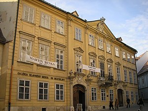
Mirbach Palace
Palace in Bratislava, Slovakia
Distance: Approx. 383 meters
Latitude and longitude: 48.1448,17.1078
Mirbach Palace is a Baroque-Rococo building in the historical zone of Bratislava, Slovakia. The four-wing, two-story building, which ranks among the most beautiful and best-preserved architectural monuments of the mentioned style period in Slovakia, was named after the last owner, Baron Dr. Emil Mirbach.

Old Cathedral of Saint John of Matha and Saint Felix of Valois
Church in Bratislava, Slovakia
Distance: Approx. 234 meters
Latitude and longitude: 48.14611111,17.10666667
The Trinitarian Church or Trinity Church, full name Church of Saint John of Matha and Saint Felix of Valois (Slovak: Kostol trinitárov, Trinitársky kostol or Trojičný kostol or Kostol svätého Jána z Mathy a svätého Felixa z Valois; incorrectly Holy Trinity Church (Kostol Najsvätejšej Trojice)), is a Baroque-style church in Bratislava's Old Town borough, on the Župné námestie square. The church was built on the site of the older Church of St. Michael, which was demolished in 1529, along with the settlement of St.
Hodžovo námestie
Square in Bratislava, Slovakia
Distance: Approx. 59 meters
Latitude and longitude: 48.14861111,17.1075
Hodžovo námestie (English: Hodžovo Square, locally referred to as Hodžko or Mierko) is a major square in Bratislava, the capital of Slovakia. The square is located at the edge of Old Town, in front of the Slovak Presidential Palace, some 5 minutes walking distance from the historical city center. It is considered to be the center of Bratislava (although Main Square is also considered to be the center) and it is the place of almost all of the foreign states visits.

New Scene
Theatre in Bratislava, Slovakia
Distance: Approx. 367 meters
Latitude and longitude: 48.14972222,17.11138889
New Scene (Slovak: Nová scéna, abr. ND) is a theatre located in Bratislava, the capital of Slovakia. It specializes in mainstream and Musical theatre such as musicals, comedies and fairy tales.
Red Crayfish Pharmacy
Defensive barbican in Old Town of Bratislava, Slovakia
Distance: Approx. 326 meters
Latitude and longitude: 48.14527778,17.10666667
Red Crayfish Pharmacy (Slovak: Lekáreň U červeného raka) is a baroque building and former pharmacy from the 16th century in the Old Town of Bratislava, Slovakia. Since 1953 it houses the Museum of Pharmacy of the Bratislava City Museum. Today, the exhibition features three of the original five rooms of the former pharmacy complete with historical furniture, pharmacy equipment and Baroque – Classicist paintings and wall decorations.

SNP Square (Bratislava)
Square in central Bratislava, Slovakia
Distance: Approx. 415 meters
Latitude and longitude: 48.145466,17.110795
Slovak National Uprising Square (SNP square; Slovak: Námestie Slovenského národného povstania, shortcut: Námestie SNP or Nám. SNP) is a square in central Bratislava, Slovakia. In the 20th century, it served as the focal point for national demonstrations for independence and sovereignty.

List of ambassadors of Italy to Slovakia
Distance: Approx. 304 meters
Latitude and longitude: 48.149068,17.103122
The Italian ambassador in Bratislava is the official representative of the Government in Rome to the Government of Slovakia.
Weather in this IP's area
mist
-1 Celsius
-6 Celsius
-2 Celsius
-0 Celsius
1016 hPa
91 %
1016 hPa
993 hPa
5000 meters
4.63 m/s
110 degree
100 %

