Country:
Region:
City:
Latitude and Longitude:
Time Zone:
Postal Code:
IP information under different IP Channel
ip-api
Country
Region
City
ASN
Time Zone
ISP
Blacklist
Proxy
Latitude
Longitude
Postal
Route
Luminati
Country
ASN
Time Zone
Europe/Istanbul
ISP
SAGLAYICI Teknoloji Bilisim Yayincilik Hiz. Ticaret Ltd. Sti.
Latitude
Longitude
Postal
IPinfo
Country
Region
City
ASN
Time Zone
ISP
Blacklist
Proxy
Latitude
Longitude
Postal
Route
db-ip
Country
Region
City
ASN
Time Zone
ISP
Blacklist
Proxy
Latitude
Longitude
Postal
Route
ipdata
Country
Region
City
ASN
Time Zone
ISP
Blacklist
Proxy
Latitude
Longitude
Postal
Route
Popular places and events near this IP address
MetroCity AVM
Distance: Approx. 57 meters
Latitude and longitude: 41.0762,29.01305
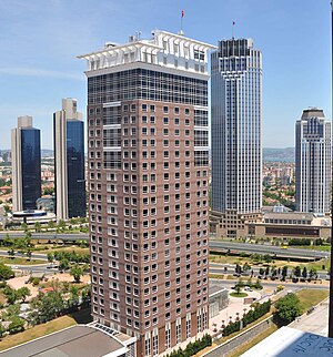
MetroCity AVM, opened on April 30, 2003, is a modern shopping mall on the Büyükdere Avenue in the finance and business quarter of 1. Levent in Istanbul, Turkey, with a direct connection to the Levent subway station. The complex comprises a shopping mall and three towers which rise above it: a 27-floor office tower on Büyükdere Avenue (31 floors when counted from the Zincirlikuyu level at the opposite side), and two residential towers, each having 31 floors (35 floors from Zincirlikuyu level).

Levent
Neighbourhood in Beşiktaş, Istanbul, Turkey
Distance: Approx. 715 meters
Latitude and longitude: 41.08181,29.01584
Levent is a neighbourhood in the municipality and district of Beşiktaş, Istanbul Province, Turkey. Its population is 2,911 (2022). It is one of the main business districts of Istanbul located on the European side of the city.

Kanyon Shopping Mall
Shopping mall in Istanbul, Turkey
Distance: Approx. 295 meters
Latitude and longitude: 41.07833333,29.01111111
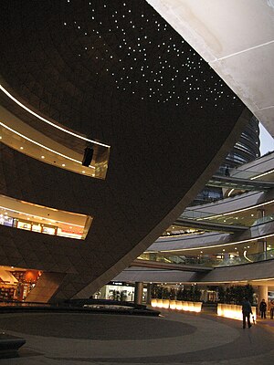
Kanyon (meaning Canyon in Turkish) is a multi-purpose complex located on the Büyükdere Avenue in the Levent business district of Istanbul, Turkey. Opened on 6 June 2006, it unites a 160-store shopping mall (covering an area of 37,500 m2), a 30-floor office tower (26 floors of which rise above street level) and a 22-floor residential block with 179 residential apartments into a complex undulating around a dramatic architectural “canyon”. The total construction area of the project is 250,000 m2, with 30,000 m2 of rentable office area, 37,500 m2 of rentable retail area, 180 residential flats, 160 stores, 9 theater halls with a capacity of 1,600 spectators, and a parking facility for 2,300 vehicles.

Isbank Tower 1
Mixed-Use in Istanbul, Turkey
Distance: Approx. 774 meters
Latitude and longitude: 41.0828,29.0114
The 52-floor Isbank (İş Bankası) Tower 1 is the tallest of the three skyscrapers of the Türkiye İş Bankası headquarters in Levent, Istanbul. It was formerly the tallest skyscraper in Turkey and the Balkans (southeastern Europe). It entered service with the ceremonies between August 23 and 26, 2000.
Zincirlikuyu Cemetery
Burial ground in Istanbul, Turkey
Distance: Approx. 364 meters
Latitude and longitude: 41.075,29.00833333
The Zincirlikuyu Cemetery (Turkish: Zincirlikuyu Mezarlığı) is a modern burial ground in the European part of Istanbul, Turkey. It is administered by the Metropolitan Municipality. Many prominent figures from the world of politics, business, sports and arts rest here.
Turkish Foundation for Combating Soil Erosion
Turkish non-governmental organization
Distance: Approx. 388 meters
Latitude and longitude: 41.07931,29.01345
The Turkish Foundation for Combating Soil Erosion (Turkish: Türkiye Erozyonla Mücadele, Ağaçlandırma ve Doğal Varlıkları Koruma Vakfı), better known in abbreviated form as TEMA, is a non-governmental organization (NGO) for reforestation and the protection of natural habitats in Turkey.
Demiroğlu Bilim University
Private university in İstanbul, Turkey
Distance: Approx. 750 meters
Latitude and longitude: 41.06916667,29.01222222
Demiroğlu Bilim University is a private university located in Istanbul, Turkey. It was established in 2006 by the Turkish Cardiology Foundation.

Zincirlikuyu
Quarter in Istanbul, Turkey
Distance: Approx. 560 meters
Latitude and longitude: 41.071,29.014
Zincirlikuyu is a quarter of the Şişli district on the European side of Istanbul, Turkey. Part of Esentepe neighborhood, it is situated on a hilltop on the district border to Beşiktaş in the east. Having undergone redevelopment in recent years, the area is also a busy bus hub.
Global Relations Forum
Distance: Approx. 625 meters
Latitude and longitude: 41.08136111,29.01422222
Global Relations Forum (GRF) is an independent, non-profit membership association founded on May 11, 2009, in Turkey with the committed support of 40 Turkish men and women who have assumed prominent roles in international fora and have received international recognition for their efforts throughout their careers. The founding members include former secretaries of state, university presidents, central bank governors, ECHR justice and retired ambassadors as well as leading business leaders, scholars, artists, and journalists. GRF is supposed to be a platform for engaging, informing and stimulating its members and all interested individuals in all matters related to international affairs and global issues.

Tekfen Tower
Mixed–Use in Istanbul, Turkey
Distance: Approx. 738 meters
Latitude and longitude: 41.08194444,29.00888889
Tekfen Tower is a skyscraper located in Levent, Istanbul, Turkey.
Levent (Istanbul Metro)
Station of the Istanbul Metro
Distance: Approx. 203 meters
Latitude and longitude: 41.077663,29.013128
Levent is an underground station on the M2 line of the Istanbul Metro. It is located under Büyükdere Avenue in Levent, the main financial district of Istanbul. Opened on 16 September 2000, Levent is one of the M2 line's six original stations.

Gayrettepe (Istanbul Metro)
Station of the Istanbul Metro
Distance: Approx. 761 meters
Latitude and longitude: 41.069165,29.010928
Gayrettepe is an underground rapid transit station on the M2 and M11 lines of the Istanbul Metro. It is located in east-central Şişli under Büyükdere Avenue just south of Levent. The M2 portion of the station opened on 16 September 2000 and is one of the original six stations of the M2 line.
Weather in this IP's area
broken clouds
12 Celsius
12 Celsius
12 Celsius
12 Celsius
1017 hPa
94 %
1017 hPa
1000 hPa
6000 meters
2.06 m/s
30 degree
75 %
07:51:58
17:45:26


