195.137.184.73 - IP Lookup: Free IP Address Lookup, Postal Code Lookup, IP Location Lookup, IP ASN, Public IP
Country:
Region:
City:
Location:
Time Zone:
Postal Code:
ISP:
ASN:
language:
User-Agent:
Proxy IP:
Blacklist:
IP information under different IP Channel
ip-api
Country
Region
City
ASN
Time Zone
ISP
Blacklist
Proxy
Latitude
Longitude
Postal
Route
db-ip
Country
Region
City
ASN
Time Zone
ISP
Blacklist
Proxy
Latitude
Longitude
Postal
Route
IPinfo
Country
Region
City
ASN
Time Zone
ISP
Blacklist
Proxy
Latitude
Longitude
Postal
Route
IP2Location
195.137.184.73Country
Region
occitanie
City
pujaudran
Time Zone
Europe/Paris
ISP
Language
User-Agent
Latitude
Longitude
Postal
ipdata
Country
Region
City
ASN
Time Zone
ISP
Blacklist
Proxy
Latitude
Longitude
Postal
Route
Popular places and events near this IP address

Bonrepos-sur-Aussonnelle
Commune in Occitania, France
Distance: Approx. 4764 meters
Latitude and longitude: 43.5467,1.1497
Bonrepos-sur-Aussonnelle is a commune of the Haute-Garonne department in southwestern France.
Mérenvielle
Commune in Occitania, France
Distance: Approx. 4393 meters
Latitude and longitude: 43.6286,1.1572
Mérenvielle is a commune in the Haute-Garonne department in southwestern France.
Pradère-les-Bourguets
Part of Lasserre-Pradère in Occitania, France
Distance: Approx. 5972 meters
Latitude and longitude: 43.6417,1.1669
Pradère-les-Bourguets (French pronunciation: [pʁadɛʁ le buʁɡɛ]; Occitan: Pradèra e les Borguets) is a former commune in the Haute-Garonne department in southwestern France. On 1 January 2018, it was merged into the new commune of Lasserre-Pradère.

Lias, Gers
Commune in Occitania, France
Distance: Approx. 3127 meters
Latitude and longitude: 43.5633,1.1358
Lias (French pronunciation: [ljas]; Occitan: Liars) is a commune in the Gers department in southwestern France.

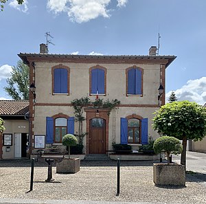
Pujaudran
Commune in Occitania, France
Distance: Approx. 245 meters
Latitude and longitude: 43.5917,1.15
Pujaudran (French pronunciation: [pyʒodʁɑ̃]) is a commune in the Gers department in southwestern France.
Ségoufielle
Commune in Occitania, France
Distance: Approx. 4979 meters
Latitude and longitude: 43.6322,1.1314
Ségoufielle (French pronunciation: [seɡufjɛl]; Segofièla in the Gascon dialect of the Occitan language) is a commune in the Gers department in the Occitanie region of southwestern France.

L'Isle-Jourdain, Gers
Commune in Occitania, France
Distance: Approx. 6150 meters
Latitude and longitude: 43.6144,1.0817
L'Isle-Jourdain (French pronunciation: [lil ʒuʁdɛ̃]; Occitan: L'Isla de Baish, [ˈlizlɔ ðe ˈβaʃ]; Catalan: Illa Jordà or L'Illa de Baix) is a commune in the Gers department, Occitania, Southwestern France. The lexicographers Claude (1854–1924) and Paul Augé (1881–1951) were born in L'isle-Jourdain as was the writer Armand Praviel (1875–1944).

Fontenilles
Commune in Occitania, France
Distance: Approx. 5208 meters
Latitude and longitude: 43.5539,1.1917
Fontenilles (French pronunciation: [fɔ̃tnij]; Occitan: Fontanilhas) is a commune in the Haute-Garonne department in southwestern France.
Lasserre, Haute-Garonne
Part of Lasserre-Pradère in Occitania, France
Distance: Approx. 5807 meters
Latitude and longitude: 43.6397,1.1694
Lasserre (French pronunciation: [lasɛʁ]; Occitan: La Sèrra) is a former commune in the Haute-Garonne department in southwestern France. On 1 January 2018, it was merged into the new commune of Lasserre-Pradère.
Canton of Léguevin
Distance: Approx. 6571 meters
Latitude and longitude: 43.6,1.23
The canton of Léguevin is an administrative division of the Haute-Garonne department, southern France. Its borders were modified at the French canton reorganisation which came into effect in March 2015. Its seat is in Léguevin.
Canton of L'Isle-Jourdain
Distance: Approx. 6072 meters
Latitude and longitude: 43.61,1.08
The canton of L'Isle-Jourdain is an administrative division of the Gers department, southwestern France. Its borders were modified at the French canton reorganisation which came into effect in March 2015. Its seat is in L'Isle-Jourdain.

Lasserre-Pradère
Commune in Occitania, France
Distance: Approx. 5807 meters
Latitude and longitude: 43.6397,1.1694
Lasserre-Pradère (French pronunciation: [lasɛʁ pʁadɛʁ]; Occitan: La Sèrra e Pradèra) is a commune in the department of Haute-Garonne, southern France. The municipality was established on 1 January 2018 by merger of the former communes of Lasserre (the seat) and Pradère-les-Bourguets.
Weather in this IP's area
light rain
11 Celsius
10 Celsius
11 Celsius
11 Celsius
1002 hPa
82 %
1002 hPa
978 hPa
10000 meters
2.06 m/s
60 degree
75 %
