195.136.32.54 - IP Lookup: Free IP Address Lookup, Postal Code Lookup, IP Location Lookup, IP ASN, Public IP
Country:
Region:
City:
Location:
Time Zone:
Postal Code:
ISP:
ASN:
language:
User-Agent:
Proxy IP:
Blacklist:
IP information under different IP Channel
ip-api
Country
Region
City
ASN
Time Zone
ISP
Blacklist
Proxy
Latitude
Longitude
Postal
Route
db-ip
Country
Region
City
ASN
Time Zone
ISP
Blacklist
Proxy
Latitude
Longitude
Postal
Route
IPinfo
Country
Region
City
ASN
Time Zone
ISP
Blacklist
Proxy
Latitude
Longitude
Postal
Route
IP2Location
195.136.32.54Country
Region
lubuskie
City
zagan
Time Zone
Europe/Warsaw
ISP
Language
User-Agent
Latitude
Longitude
Postal
ipdata
Country
Region
City
ASN
Time Zone
ISP
Blacklist
Proxy
Latitude
Longitude
Postal
Route
Popular places and events near this IP address

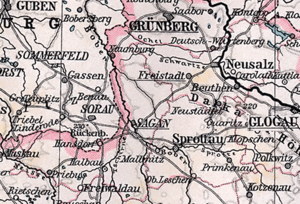
Żagań
Place in Lubusz Voivodeship, Poland
Distance: Approx. 160 meters
Latitude and longitude: 51.61666667,15.31666667
Żagań [ˈʐaɡaɲ] (French and German: Sagan, Latin: Saganum) is a town in western Poland, on the Bóbr river, with 25,731 inhabitants (2019). The town is the capital of Żagań County in the historic region of Silesia. Previously in the Zielona Góra Voivodeship (1975–1998), Żagań has been in the Lubusz Voivodeship since 1999.

Żagań County
County in Lubusz Voivodeship, Poland
Distance: Approx. 160 meters
Latitude and longitude: 51.61666667,15.31666667
Żagań County (Polish: powiat żagański) is a unit of territorial administration and local government (powiat) in Lubusz Voivodeship, western Poland. It came into being on January 1, 1999, as a result of the Polish local government reforms passed in 1998. Its administrative seat and largest town is Żagań, which lies 39 km (24 mi) south of Zielona Góra and 124 km (77 mi) south of Gorzów Wielkopolski.

Stalag Luft III
World War II Luftwaffe-run prisoner of war camp
Distance: Approx. 2176 meters
Latitude and longitude: 51.5986,15.3075
Stalag Luft III (German: Stammlager Luft III; literally "Main Camp, Air, III"; SL III) was a Luftwaffe-run prisoner-of-war (POW) camp during the Second World War, which held captured Western Allied air force personnel. The camp was established in March 1942 near the town of Sagan, Lower Silesia, in what was then Nazi Germany (now Żagań, Poland), 160 km (100 mi) south-east of Berlin. The site was selected because its sandy soil made it difficult for POWs to escape by tunnelling.
Gmina Żagań
Gmina in Lubusz Voivodeship, Poland
Distance: Approx. 160 meters
Latitude and longitude: 51.61666667,15.31666667
Gmina Żagań is a rural gmina (administrative district) in Żagań County, Lubusz Voivodeship, in western Poland. Its seat is the town of Żagań, although the town is not part of the territory of the gmina. The gmina covers an area of 281.11 square kilometres (108.5 sq mi), and as of 2019 its total population is 7,324.

Kreis Sagan
Distance: Approx. 160 meters
Latitude and longitude: 51.6167,15.3167
Kreis Sagan was a Prussian district in Silesia, with its capital at Sagan. It existed until 1932, when it was dissolved and most of its territory was merged into the Sprottau district, with some smaller areas being assigned to other adjacent districts.
Bożnów
Village in Lubusz Voivodeship, Poland
Distance: Approx. 3580 meters
Latitude and longitude: 51.61666667,15.36666667
Bożnów [ˈbɔʐnuf] is a village in the administrative district of Gmina Żagań, within Żagań County, Lubusz Voivodeship, in western Poland.
Chrobrów
Village in Lubusz Voivodeship, Poland
Distance: Approx. 4521 meters
Latitude and longitude: 51.58333333,15.35
Chrobrów [ˈxrɔbruf] is a village in the administrative district of Gmina Żagań, within Żagań County, Lubusz Voivodeship, in western Poland. It lies approximately 5 kilometres (3 mi) south-east of Żagań and 41 km (25 mi) south of Zielona Góra.
Marysin, Lubusz Voivodeship
Village in Lubusz Voivodeship, Poland
Distance: Approx. 3056 meters
Latitude and longitude: 51.63722222,15.34583333
Marysin [maˈrɨɕin] is a village in the administrative district of Gmina Żagań, within Żagań County, Lubusz Voivodeship, in western Poland.
Pożarów, Lubusz Voivodeship
Village in Lubusz Voivodeship, Poland
Distance: Approx. 3609 meters
Latitude and longitude: 51.65,15.31666667
Pożarów [pɔˈʐaruf] is a village in the administrative district of Gmina Żagań, within Żagań County, Lubusz Voivodeship, in western Poland. Pożarów is approximately 4 kilometres (2 mi) north of Żagań and 35 km (22 mi) south of Zielona Góra.
Puszczyków
Settlement in Lubusz Voivodeship, Poland
Distance: Approx. 2519 meters
Latitude and longitude: 51.64,15.30972222
Puszczyków [puʂˈt͡ʂɨkuf] is a settlement in the administrative district of Gmina Żagań, within Żagań County, Lubusz Voivodeship, in western Poland. It lies approximately 3 kilometres (2 mi) north of Żagań and 36 km (22 mi) south of Zielona Góra.

Stary Żagań
Village in Lubusz Voivodeship, Poland
Distance: Approx. 3609 meters
Latitude and longitude: 51.65,15.31666667
Stary Żagań [ˈstarɨ ˈʐaɡaɲ] is a village in the administrative district of Gmina Żagań, within Żagań County, Lubusz Voivodeship, in western Poland. It lies approximately 4 kilometres (2 mi) north of Żagań and 35 km (22 mi) south of Zielona Góra.

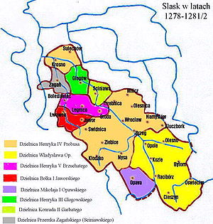
Duchy of Żagań
Silesian duchy (1274–1549)
Distance: Approx. 160 meters
Latitude and longitude: 51.616667,15.316667
The Duchy of Żagań (Polish: Księstwo Żagańskie, Czech: Zaháňské knížectví) or Duchy of Sagan (German: Herzogtum Sagan) was one of the duchies of Silesia ruled by the Silesian Piasts. Its capital was Żagań in Lower Silesia, the territory stretched to the town of Nowogród Bobrzański in the north and reached the Lusatian Neisse at Przewóz in the west, including two villages beyond the river (Pechern and Neudorf). It was formed in 1274 from the western part of the Duchy of Głogów and existed under Piast rule until 1304, then again from 1322 to 1394 and from 1413 to 1472.
Weather in this IP's area
overcast clouds
-1 Celsius
-4 Celsius
-1 Celsius
-1 Celsius
1009 hPa
84 %
1009 hPa
993 hPa
10000 meters
2.31 m/s
6.52 m/s
209 degree
91 %